Rural Municipality of Eldon No. 471

Last updated

Eldon No. 471
Rural Municipality of Eldon No. 471
SK RM 471 Eldon.svg
Location of the RM of Eldon No. 471 in Saskatchewan
Coordinates: 53°19′05″N109°23′46″W / 53.318°N 109.396°W / 53.318; -109.396 [1]
Country Canada
Province Saskatchewan
Census division 17
SARM division 6
Formed [2] December 13, 1909
Government
[3]
   Reeve Larry Lundquist
  Governing bodyRM of Eldon No. 471 Council
  AdministratorLee Torrance
  Office location Maidstone
Area
 (2016) [4]
  Land1,007.59 km2 (389.03 sq mi)
Population
 (2016) [4]
  Total750
  Density0.7/km2 (2/sq mi)
Time zone CST
  Summer (DST) CST
Area code(s) 306 and 639

The Rural Municipality of Eldon No. 471 (2016 population: 750) is a rural municipality (RM) in the Canadian province of Saskatchewan within Census Division No. 17 and SARM Division No. 6.

Contents

History

The RM of Eldon No. 471 incorporated as a rural municipality on December 13, 1909. [2] It was originally formed as Local Improvement District 24-5-3 on April 26, 1907.[ citation needed ]

Geography

Communities and localities

The following urban municipalities are surrounded by the RM.

Towns
Villages

Silver Lake Regional Park

Silver Lake Regional Park ( 53°13′42″N109°16′04″W / 53.2284°N 109.2679°W / 53.2284; -109.2679 ) [5] is in the RM of Eldon on the eastern part of Silver Lake. At over 105 ha (260 acres), the park has a campground with 128 campsites, a 9-hole golf course, beach, ball diamonds, mini golf, laundry facilities, hiking trails, and a picnic area. Access is from Highway 21, about 12 kilometres (7.5 mi)} north of Maidstone. [6]

In 1961, a swimming area was established on Silver Lake. By 1963, there had a picnic area, playground, sports ground, and a concession. One year later, in 1964, it was established as a regional park. Since then, the park has expanded and added more amenities. At about 85 ha (210 acres), [7] Silver Lake is a small lake that has its outflow into the neighbouring Big Gully Creek. In 1971, a dyke was built at the lake's outflow to stabilise water levels and improve the beach. [8]

Silver Lake Golf Club is a 9-hole, par 36 course totalling 3,160 yards with grass greens. The clubhouse is licensed and serves food. There are also a pro shop and club and cart rentals. [9]

Demographics

Population history
(1981–2016)
YearPop.±%
1981964    
19861,010+4.8%
1991882−12.7%
1996 838−5.0%
2001 766−8.6%
2006 750−2.1%
2011 751+0.1%
2016 750−0.1%
Source: Statistics Canada via Saskatchewan Bureau of Statistics [10] [11]

In the 2021 Census of Population conducted by Statistics Canada, the RM of Eldon No. 471 had a population of 700 living in 277 of its 303 total private dwellings, a change of

In the 2016 Census of Population, the RM of Eldon No. 471 recorded a population of 750 living in 275 of its 314 total private dwellings, a

Government

The RM of Eldon No. 471 is governed by an elected municipal council and an appointed administrator that meets on the second Wednesday of every month. [3] The reeve of the RM is Larry Lundquist while its administrator is Lee Torrance. [3] The RM's office is located in Maidstone. [3]

Related Research Articles

<span class="mw-page-title-main">Rural Municipality of Maple Bush No. 224</span> Rural municipality in Saskatchewan, Canada

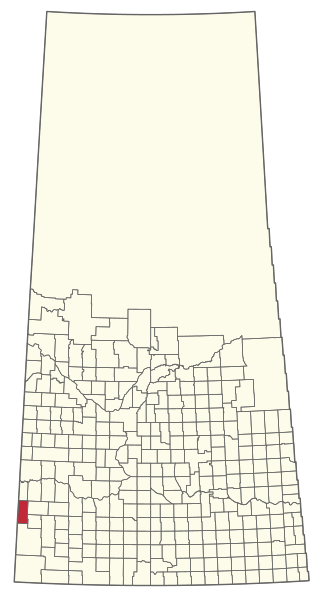
The Rural Municipality of Maple Bush No. 224 is a rural municipality (RM) in the Canadian province of Saskatchewan within Census Division No. 7 and SARM Division No. 2. It is located in the southwest portion of the province.

<span class="mw-page-title-main">Rural Municipality of Leask No. 464</span> Rural municipality in Saskatchewan, Canada

The Rural Municipality of Leask No. 464 is a rural municipality (RM) in the Canadian province of Saskatchewan within Census Division No. 16 and SARM Division No. 5. It is located west of the city of Prince Albert.

<span class="mw-page-title-main">Rural Municipality of Senlac No. 411</span> Rural municipality in Saskatchewan, Canada

The Rural Municipality of Senlac No. 411 is a rural municipality (RM) in the Canadian province of Saskatchewan within Census Division No. 13 and SARM Division No. 6. Located in the west-central portion of the province, it is adjacent to the Alberta boundary.

<span class="mw-page-title-main">Rural Municipality of Canwood No. 494</span> Rural municipality in Saskatchewan, Canada

The Rural Municipality of Canwood No. 494 is a rural municipality (RM) in the Canadian province of Saskatchewan within Census Division No. 16 and SARM Division No. 5. The RM is located in the north-central portion of the province, west of the city of Prince Albert.

<span class="mw-page-title-main">Rural Municipality of Meadow Lake No. 588</span> Rural municipality in Saskatchewan, Canada

The Rural Municipality of Meadow Lake No. 588 is a rural municipality (RM) in the Canadian province of Saskatchewan within Census Division No. 17 and SARM Division No. 6.

<span class="mw-page-title-main">Rural Municipality of Enterprise No. 142</span> Rural municipality in Saskatchewan, Canada

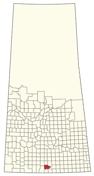
The Rural Municipality of Enterprise No. 142 is a rural municipality (RM) in the Canadian province of Saskatchewan within Census Division No. 8 and SARM Division No. 3. It is located in the southwest portion of the province.

<span class="mw-page-title-main">Maidstone, Saskatchewan</span> Town in Saskatchewan, Canada

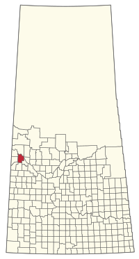
Maidstone is a town in west central Saskatchewan, Canada located 57 km east of Lloydminster and 84 km west of North Battleford at the junction of Highway 16 and Highway 21. The community was named after Maidstone, Kent, England.

<span class="mw-page-title-main">Rural Municipality of Gravelbourg No. 104</span> Rural municipality in Saskatchewan, Canada

The Rural Municipality of Gravelbourg No. 104 is a rural municipality (RM) in the Canadian province of Saskatchewan within Census Division No. 3 and SARM Division No. 2. It is located in the southwest portion of the province.

<span class="mw-page-title-main">Rural Municipality of Pense No. 160</span> Rural municipality in Saskatchewan, Canada

The Rural Municipality of Pense No. 160 is a rural municipality (RM) in the Canadian province of Saskatchewan within Census Division No. 6 and SARM Division No. 2. It is located in the southeast portion of the province.

<span class="mw-page-title-main">Rural Municipality of Moosomin No. 121</span> Rural municipality in Saskatchewan, Canada

The Rural Municipality of Moosomin No. 121 is a rural municipality (RM) in the Canadian province of Saskatchewan within Census Division No. 5 and SARM Division No. 1. It is located in the southeast portion of the province.

<span class="mw-page-title-main">Rural Municipality of Britannia No. 502</span> Rural municipality in Saskatchewan, Canada

The Rural Municipality of Britannia No. 502 is a rural municipality (RM) in the Canadian province of Saskatchewan within Census Division No. 17 and SARM Division No. 6. It is located in the west-central portion of the province.

<span class="mw-page-title-main">Rural Municipality of Mayfield No. 406</span> Rural municipality in Saskatchewan, Canada

The Rural Municipality of Mayfield No. 406 is a rural municipality (RM) in the Canadian province of Saskatchewan within Census Division No. 16 and SARM Division No. 6.

<span class="mw-page-title-main">Rural Municipality of Souris Valley No. 7</span> Rural municipality in Saskatchewan, Canada

The Rural Municipality of Souris Valley No. 7 is a rural municipality (RM) in the Canadian province of Saskatchewan within Census Division No. 2 and SARM Division No. 1. Located in the southeast portion of the province, it is adjacent to the United States border, neighbouring Divide County in North Dakota.

<span class="mw-page-title-main">Rural Municipality of Spy Hill No. 152</span> Rural municipality in Saskatchewan, Canada

The Rural Municipality of Spy Hill No. 152 is a rural municipality (RM) in the Canadian province of Saskatchewan within Census Division No. 5 and SARM Division No. 1. It is located in the east-central portion of the province.

<span class="mw-page-title-main">Rural Municipality of Willow Bunch No. 42</span> Rural municipality in Saskatchewan, Canada

The Rural Municipality of Willow Bunch No. 42 is a rural municipality (RM) in the Canadian province of Saskatchewan within Census Division No. 3 and SARM Division No. 2. It is located in the south central portion of the province.

<span class="mw-page-title-main">Rural Municipality of Snipe Lake No. 259</span> Rural municipality in Saskatchewan, Canada

The Rural Municipality of Snipe Lake No. 259 is a rural municipality (RM) in the Canadian province of Saskatchewan within Census Division No. 8 and SARM Division No. 3.

<span class="mw-page-title-main">Rural Municipality of Riverside No. 168</span> Rural municipality in Saskatchewan, Canada

The Rural Municipality of Riverside No. 168 is a rural municipality (RM) in the Canadian province of Saskatchewan within Census Division No. 8 and SARM Division No. 3.

<span class="mw-page-title-main">Rural Municipality of Ituna Bon Accord No. 246</span> Rural municipality in Saskatchewan, Canada

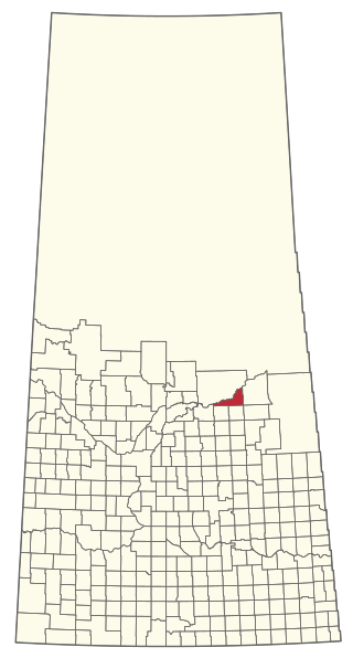
The Rural Municipality of Ituna Bon Accord No. 246 is a rural municipality (RM) in the Canadian province of Saskatchewan within Census Division No. 10 and SARM Division No. 4.

<span class="mw-page-title-main">Rural Municipality of Nipawin No. 487</span> Rural municipality in Saskatchewan, Canada

The Rural Municipality of Nipawin No. 487 is a rural municipality (RM) in the Canadian province of Saskatchewan within Census Division No. 14 and SARM Division No. 4.

<span class="mw-page-title-main">Rural Municipality of Pleasantdale No. 398</span> Rural municipality in Saskatchewan, Canada

The Rural Municipality of Pleasantdale No. 398 is a rural municipality (RM) in the Canadian province of Saskatchewan within Census Division No. 14 and SARM Division No. 4.

References

  1. "Pre-packaged CSV files - CGN, Canada/Province/Territory (cgn_sk_csv_eng.zip)". Government of Canada. July 24, 2019. Retrieved May 23, 2020.
  2. 1 2 "Rural Municipality Incorporations (Alphabetical)". Saskatchewan Ministry of Municipal Affairs. Archived from the original on April 21, 2011. Retrieved May 9, 2020.
  3. 1 2 3 4 "Municipality Details: RM of Eldon No. 471". Government of Saskatchewan. Retrieved May 21, 2020.
  4. 1 2 3 "Population and dwelling counts, for Canada, provinces and territories, and census subdivisions (municipalities), 2016 and 2011 censuses – 100% data (Saskatchewan)". Statistics Canada. February 8, 2017. Retrieved May 1, 2020.
  5. "Silver Lake Regional Park". Canadian Geographical Names Database. Government of Canada. Retrieved September 7, 2023.
  6. "Silver Lake Regional Park and Golf Course". Tourism Saskatchewan. Government of Saskatchewan. Retrieved September 9, 2023.
  7. "Silver Lake". Sask Lakes. SaskLakes. Retrieved September 9, 2023.
  8. "Silver Lake". Regional Parks of Saskatchewan. Saskatchewan Regional Parks. Retrieved September 9, 2023.
  9. "Silver Lake Golf Club". GolfPass. Retrieved September 9, 2023.
  10. "Saskatchewan Census Population" (PDF). Saskatchewan Bureau of Statistics. Archived from the original (PDF) on September 24, 2015. Retrieved May 9, 2020.
  11. "Saskatchewan Census Population". Saskatchewan Bureau of Statistics. Retrieved May 9, 2020.
  12. "Population and dwelling counts: Canada, provinces and territories, census divisions and census subdivisions (municipalities), Saskatchewan". Statistics Canada. February 9, 2022. Retrieved April 13, 2022.