Rural Municipality of Manitou Lake No. 442

Last updated

Manitou Lake No. 442
Rural Municipality of Manitou Lake No. 442
Manitou Lake RM office.JPG
RM's office in Marsden
SK RM 442 Manitou Lake.svg
Location of the RM of Manitou Lake No. 442 in Saskatchewan
Coordinates: 52°53′06″N109°46′05″W / 52.885°N 109.768°W / 52.885; -109.768 [1]
Country Canada
Province Saskatchewan
Census division 13
SARM division 6
Federal riding Battlefords—Lloydminster
Provincial riding Cut Knife-Turtleford
Formed [2] December 12, 1910
Government
[3]
   Reeve Brian Graham
  Governing bodyRM of Manitou Lake No. 442 Council
  AdministratorJoanne Loy
  Office location Marsden
Area
 (2016) [4]
  Land850.95 km2 (328.55 sq mi)
Population
 (2016) [4]
  Total573
  Density0.7/km2 (2/sq mi)
Time zone CST
  Summer (DST) CST
Postal code
S0M 1P0
Area code(s) 306 and 639
Website Official website

The Rural Municipality of Manitou Lake No. 442 (2016 population: 573) is a rural municipality (RM) in the Canadian province of Saskatchewan within Census Division No. 13 and SARM Division No. 6.

Contents

History

The RM of Manitou Lake No. 442 incorporated as a rural municipality on December 12, 1910. [2] It takes its name from Manitou Lake, which is Algonquian for "mysterious being".

In 1905, the first settlers came from Canadian regions, the British Isles, and the United States. The area was known as the Manitou Lake District. In 1907-1908 a post office was established in the home of Mr. Alex Wright, approximately one mile north-east of the present Marsden town site. The post office served the surrounding rural area. The Wrights named the post office 'Marsden'. One story recounts the name as originating from the birthplace of Mrs. Wright in Yorkshire, England; another reports it was named after the famous Marsden Rock near Newcastle, England. The adjacent area became known as the Marsden Rural Post Office District. Between 1919 and 1922, the post office was relocated one mile south to the RM office of Manitou Lake No. 442.

In 1905, the vast prairie land was covered with long grass referred to as 'prairie wool'. There were few trees or bluffs. The fertile black soil attracted many first settlers to the area and soon farms developed with sod and log homes. Farmers turned sod with horse and ox teams, sometimes using a walking plough (sulky) to prepare the ground for grain sowing. Grain was cut with binders, stooked, and threshed. Farmers hauled grain by wagon or horse-drawn sleigh to Zumbro and Artland. In the winter months, grain was hauled across the ice of Manitou Lake. Early settlers purchased groceries and supplies at Lashburn, Artland, or Chauvin, Alberta. A popular shopping method of the time was the Eaton's catalogue.

The settler's children first attended school in Learig, and in 1925 a four-room schoolhouse was built in the hamlet of Marsden.

Geography

Communities and localities

The following urban municipalities are surrounded by the RM.

Villages

The following unincorporated communities are within the RM.

Localities

Lakes and rivers

The following is a list of notable lakes and rivers in the RM:

Demographics

Population history
(1981–2016)
YearPop.±%
1981687    
1986727+5.8%
1991631−13.2%
1996 618−2.1%
2001 604−2.3%
2006 590−2.3%
2011 547−7.3%
2016 573+4.8%
Source: Statistics Canada via Saskatchewan Bureau of Statistics [5] [6]

In the 2021 Census of Population conducted by Statistics Canada, the RM of Manitou Lake No. 442 had a population of 505 living in 199 of its 250 total private dwellings, a change of

In the 2016 Census of Population, the RM of Manitou Lake No. 442 recorded a population of 573 living in 209 of its 236 total private dwellings, a

Economy

Agriculture, cattle, and oil are primary industries for the population of 590 residents of the RM of Manitou Lake. Wheat, canola, barley, oats, peas, and flax are typical crops in the area. The region is famous for its prize-winning purebred cattle that include Hereford, Charolais, Simmental, and Angus. Agriculture diversification is noticeable with specialty livestock production such as elk and bison.

The oil industry plays a significant role in the local economy. Oil wells and batteries in the countryside evidence heavy crude oil extraction in the region.

Transportation

The following is a list of Saskatchewan highways in the RM:

Big Manitou Regional Park

Big Manitou Regional Park ( 52°47′48″N109°47′19″W / 52.7967°N 109.7886°W / 52.7967; -109.7886 ) is a regional park located on the north-west corner of Manitou Lake, near where the creek that drains Wells Lake flows into Manitou Lake. This park was originally established in 1975 as a part of Suffern Lake Regional Park. [8] In 2019, it was granted full park status and officially named Big Manitou Regional Park [9] It is located about 6.4 kilometres (4.0 mi) south and east of Marsden. The park facilities include a campground with 32 campsites, showers, cookhouse, playgrounds, horseshoe pits, ball diamonds, and a soccer field. Manitou Lake Golf Club [10] is also located in the park. It is a 9-hole, sand greens course.

Manitou Sand Hills

Manitou Sand Hills are 105,000 acres of Crown grazing land set aside by the Saskatchewan government that surround much of the southern half of Manitou Lake in the southern portion of the RM. There is camping and guided trail rides through the Manitou Sand Hills, which are one of Western Canada's most distinctive landscapes. [11]

Government

The RM of Manitou Lake No. 442 is governed by an elected municipal council and an appointed administrator that meets on the first Thursday after the first Tuesday of every month. [3] The reeve of the RM is Brian Graham while its administrator is Joanne Loy. [3] The RM's office is located in Marsden. [3]

See also

Related Research Articles

<span class="mw-page-title-main">Rural Municipality of Morris No. 312</span> Rural Municipality in Saskatchewan, Canada

The Rural Municipality of Morris No. 312 is a rural municipality (RM) in the Canadian province of Saskatchewan within Census Division No. 11 and SARM Division No. 5.

<span class="mw-page-title-main">Rural Municipality of Senlac No. 411</span> Rural municipality in Saskatchewan, Canada

The Rural Municipality of Senlac No. 411 is a rural municipality (RM) in the Canadian province of Saskatchewan within Census Division No. 13 and SARM Division No. 6. Located in the west-central portion of the province, it is adjacent to the Alberta boundary.

<span class="mw-page-title-main">Rural Municipality of Stonehenge No. 73</span> Rural Municipality in Saskatchewan, Canada

The Rural Municipality of Stonehenge No. 73 is a rural municipality (RM) in the Canadian province of Saskatchewan within Census Division No. 3 and SARM Division No. 2. It is located in the south-central portion of the province.

<span class="mw-page-title-main">Manitou Lake (Saskatchewan)</span> Salt lake in Saskatchewan, Canada

Manitou Lake is a salt lake located mostly in the RM of Manitou Lake No. 422 in the Canadian province of Saskatchewan, about 10 kilometres (6.2 mi) east of the provincial border with Alberta. The eastern shore of the lake is in the RM of Hillsdale No. 440. Manitou Lake is located in a region called the Prairie Pothole Region of North America, which extends throughout three Canadian provinces and five U.S. states. It is also within Palliser's Triangle and the Great Plains ecoregion. Manitou Lake is part of an Important Bird Area (IBA) of Canada that covers 699.66 km2 (270.14 sq mi) of land and serval neighbouring lakes.

<span class="mw-page-title-main">Rural Municipality of Enterprise No. 142</span> Rural municipality in Saskatchewan, Canada

The Rural Municipality of Enterprise No. 142 is a rural municipality (RM) in the Canadian province of Saskatchewan within Census Division No. 8 and SARM Division No. 3. It is located in the southwest portion of the province.

<span class="mw-page-title-main">Rural Municipality of Edenwold No. 158</span> Rural municipality in Saskatchewan, Canada

The Rural Municipality of Edenwold No. 158 is a rural municipality (RM) in the Canadian province of Saskatchewan within Census Division No. 6 and SARM Division No. 2. It is located in the southeast portion of the portion of the province, east of the City of Regina.

<span class="mw-page-title-main">Marsden, Saskatchewan</span> Village in Saskatchewan, Canada

Marsden is a village in the Canadian province of Saskatchewan within the Rural Municipality of Manitou Lake No. 442 and Census Division No. 13. It gained notoriety shortly after the impact of the Buzzard Coulee meteorite near the village on 20 November 2008.

<span class="mw-page-title-main">Neilburg</span> Village in Saskatchewan, Canada

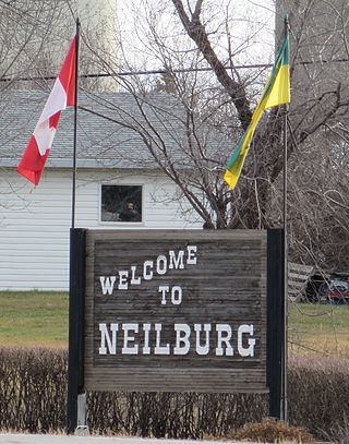
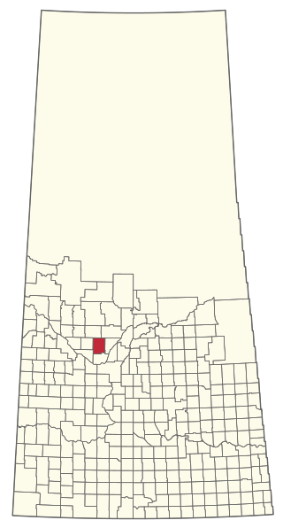
Neilburg is a village in the Canadian province of Saskatchewan within the Rural Municipality of Hillsdale No. 440 and Census Division No. 13. A grade K–12 school is located in the village that services the Neilburg area as well as grade 7–12 students from Marsden.

<span class="mw-page-title-main">Rural Municipality of Elfros No. 307</span> Rural municipality in Saskatchewan, Canada

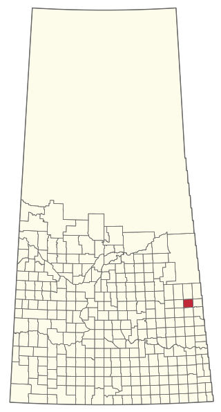
The Rural Municipality of Elfros No. 307 is a rural municipality (RM) in the Canadian province of Saskatchewan within Census Division No. 10 and SARM Division No. 4. It is located in the east-central portion of the province.

<span class="mw-page-title-main">Rural Municipality of Victory No. 226</span> Rural municipality in Saskatchewan, Canada

The Rural Municipality of Victory No. 226 is a rural municipality (RM) in the Canadian province of Saskatchewan within Census Division No. 7 and SARM Division No. 3.

<span class="mw-page-title-main">Rural Municipality of Willow Bunch No. 42</span> Rural Municipality in Saskatchewan, Canada

The Rural Municipality of Willow Bunch No. 42 is a rural municipality (RM) in the Canadian province of Saskatchewan within Census Division No. 3 and SARM Division No. 2. It is located in the south central portion of the province.

<span class="mw-page-title-main">Rural Municipality of Big River No. 555</span> Rural municipality in Saskatchewan, Canada

The Rural Municipality of Big River No. 555 is a rural municipality (RM) in the Canadian province of Saskatchewan within Census Division No. 16 and SARM Division No. 5.

<span class="mw-page-title-main">Rural Municipality of Good Lake No. 274</span> Rural municipality in Saskatchewan, Canada

The Rural Municipality of Good Lake No. 274 is a rural municipality (RM) in the Canadian province of Saskatchewan within Census Division No. 9 and SARM Division No. 4.

<span class="mw-page-title-main">Rural Municipality of Hillsdale No. 440</span> Rural municipality in Saskatchewan, Canada

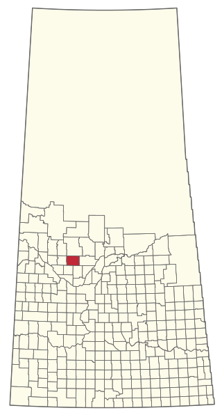
The Rural Municipality of Hillsdale No. 440 is a rural municipality (RM) in the Canadian province of Saskatchewan within Census Division No. 13 and SARM Division No. 6.

<span class="mw-page-title-main">Rural Municipality of Keys No. 303</span> Rural municipality in Saskatchewan, Canada

The Rural Municipality of Keys No. 303 is a rural municipality (RM) in the Canadian province of Saskatchewan within Census Division No. 9 and SARM Division No. 4.

<span class="mw-page-title-main">Rural Municipality of Last Mountain Valley No. 250</span> Rural municipality in Saskatchewan, Canada

The Rural Municipality of Last Mountain Valley No. 250 is a rural municipality (RM) in the Canadian province of Saskatchewan within Census Division No. 11 and SARM Division No. 5.

<span class="mw-page-title-main">Rural Municipality of Rudy No. 284</span> Rural Municipality in Saskatchewan, Canada

The Rural Municipality of Rudy No. 284 is a rural municipality (RM) in the Canadian province of Saskatchewan within Census Division No. 11 and SARM Division No. 5.

<span class="mw-page-title-main">Rural Municipality of Meeting Lake No. 466</span> Rural municipality in Saskatchewan, Canada

The Rural Municipality of Meeting Lake No. 466 is a rural municipality (RM) in the Canadian province of Saskatchewan within Census Division No. 16 and SARM Division No. 6.

<span class="mw-page-title-main">Rural Municipality of Parkdale No. 498</span> Rural Municipality in Saskatchewan, Canada

The Rural Municipality of Parkdale No. 498 is a rural municipality (RM) in the Canadian province of Saskatchewan within Census Division No. 17 and SARM Division No. 6.

<span class="mw-page-title-main">Rural Municipality of Redberry No. 435</span> Rural Municipality in Saskatchewan, Canada

The Rural Municipality of Redberry No. 435 is a rural municipality (RM) in the Canadian province of Saskatchewan within Census Division No. 16 and SARM Division No. 5.

References

  1. "Pre-packaged CSV files - CGN, Canada/Province/Territory (cgn_sk_csv_eng.zip)". Government of Canada. July 24, 2019. Retrieved May 23, 2020.
  2. 1 2 "Rural Municipality Incorporations (Alphabetical)". Saskatchewan Ministry of Municipal Affairs. Archived from the original on April 21, 2011. Retrieved May 9, 2020.
  3. 1 2 3 4 "Municipality Details: RM of Manitou Lake No. 442". Government of Saskatchewan. Retrieved May 21, 2020.
  4. 1 2 3 "Population and dwelling counts, for Canada, provinces and territories, and census subdivisions (municipalities), 2016 and 2011 censuses – 100% data (Saskatchewan)". Statistics Canada. February 8, 2017. Retrieved May 1, 2020.
  5. "Saskatchewan Census Population" (PDF). Saskatchewan Bureau of Statistics. Archived from the original (PDF) on September 24, 2015. Retrieved May 9, 2020.
  6. "Saskatchewan Census Population". Saskatchewan Bureau of Statistics. Retrieved May 9, 2020.
  7. "Population and dwelling counts: Canada, provinces and territories, census divisions and census subdivisions (municipalities), Saskatchewan". Statistics Canada. February 9, 2022. Retrieved April 13, 2022.
  8. Government of Canada, Natural Resources Canada. "Place names - Suffern Lake Regional Park (Manitou Section)". www4.rncan.gc.ca.
  9. "Big Manitou". Regional Parks of Saskatchewan. Saskatchewan Regional Parks. Retrieved March 28, 2023.
  10. "Manitou Lake Golf Club". Golf Link. LoveToKnow Corp. Retrieved March 28, 2023.
  11. "Ministers Release Manitou Sand Hills Integrated Land Use Plan". Saskatchewan. Government of Saskatchewan. October 3, 1996. Retrieved March 28, 2023.