Rural Municipality of Britannia No. 502

Last updated

Britannia No. 502
Rural Municipality of Britannia No. 502
SK RM 502 Britannia.svg
Location of the RM of Britannia No. 502 in Saskatchewan
Coordinates: 53°30′18″N109°41′53″W / 53.505°N 109.698°W / 53.505; -109.698 [1]
Country Canada
Province Saskatchewan
Census division 17
SARM division 6
Formed [2] December 13, 1909
Government
[3]
   Reeve John Light
  Governing bodyRM of Britannia No. 502 Council
  AdministratorDale Crush
  Office location Lloydminster
Area
 (2016) [4]
  Land950.39 km2 (366.95 sq mi)
Population
 (2016) [4]
  Total2,153
  Density2.3/km2 (6/sq mi)
Time zone MST
  Summer (DST) MST
Area code(s) 306 and 639
Website Official website

The Rural Municipality of Britannia No. 502 (2016 population: 2,153) is a rural municipality (RM) in the Canadian province of Saskatchewan within Census Division No. 17 and SARM Division No. 6. It is located in the west-central portion of the province.

Contents

History

The RM of Britannia No. 502 incorporated as a rural municipality on December 13, 1909. [2]

Geography

The RM of Britannia No. 502 is bounded by the Saskatchewan-Alberta border/Highway 17 to the west and the North Saskatchewan River to the north. [5] Adjacent municipalities include the City of Lloydminster to the southwest, the County of Vermilion River in Alberta to the west, the RM of Frenchman Butte No. 501 to the north, the RM of Eldon No. 471 to the east and the RM of Wilton No. 472 to the south. [5] [6]

Communities and localities

The following unincorporated communities are within the RM.

Localities [7]

Demographics

Population history
(1981–2016)
YearPop.±%
19811,375    
19861,453+5.7%
19911,332−8.3%
1996 1,358+2.0%
2001 1,382+1.8%
2006 1,501+8.6%
2011 1,734+15.5%
2016 2,153+24.2%
Source: Statistics Canada via Saskatchewan Bureau of Statistics [8] [9]

In the 2021 Census of Population conducted by Statistics Canada, the RM of Britannia No. 502 had a population of 2,061 living in 744 of its 848 total private dwellings, a change of

In the 2016 Census of Population, the RM of Britannia No. 502 recorded a population of 2,153 living in 744 of its 836 total private dwellings, a

Sandy Beach Regional Park

Sandy Beach Regional Park ( 53°27′00″N109°59′33″W / 53.4501°N 109.9925°W / 53.4501; -109.9925 ) [11] is a regional park in the RM on the southern and eastern shores of Sandybeach Lake. [12] The park, which was founded in 1966, is about 19 kilometres (12 mi) north of Lloydminster near the border with Alberta. Access is from Highway 17. [13]

Amenities at Sandy Beach Regional Park include a campground, golf course, boat launch, beach area, ball diamond, concession, and a washrooms / shower facility. [14]

The golf course is a 9-hole course with grass greens. It is a par 35 with 3,099 total yards. There is also a 3-hole practice facility and a clubhouse with rentals. [15]

Government

The RM of Britannia No. 502 is governed by an elected municipal council and an appointed administrator that meets on the second and fourth Wednesday of every month. [3] The reeve of the RM is John Light while its administrator is Dale Crush. [3] The RM's office is located in Lloydminster. [3]

Related Research Articles

<span class="mw-page-title-main">Rural Municipality of Sarnia No. 221</span> Rural municipality in Saskatchewan, Canada

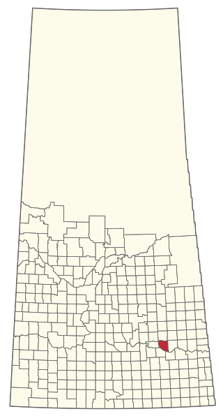
The Rural Municipality of Sarnia No. 221 is a rural municipality (RM) in the Canadian province of Saskatchewan within Census Division No. 6 and SARM Division No. 2. It is located in the south-central portion of the province.

<span class="mw-page-title-main">Rural Municipality of Maple Bush No. 224</span> Rural municipality in Saskatchewan, Canada

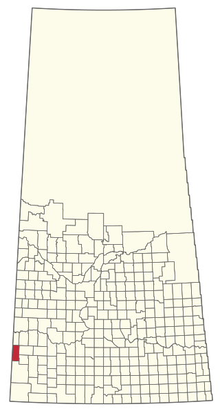
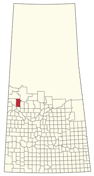
The Rural Municipality of Maple Bush No. 224 is a rural municipality (RM) in the Canadian province of Saskatchewan within Census Division No. 7 and SARM Division No. 2. It is located in the southwest portion of the province.

<span class="mw-page-title-main">Rural Municipality of Abernethy No. 186</span> Rural municipality in Saskatchewan, Canada

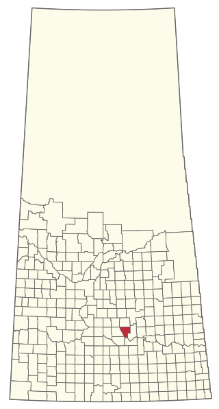
The Rural Municipality of Abernethy No. 186 is a rural municipality (RM) in the Canadian province of Saskatchewan within Census Division No. 6 and SARM Division No. 1. It is located on the Qu'Appelle River.

<span class="mw-page-title-main">Rural Municipality of Leask No. 464</span> Rural municipality in Saskatchewan, Canada

The Rural Municipality of Leask No. 464 is a rural municipality (RM) in the Canadian province of Saskatchewan within Census Division No. 16 and SARM Division No. 5. It is located west of the city of Prince Albert.

<span class="mw-page-title-main">Rural Municipality of McKillop No. 220</span> Rural municipality in Saskatchewan, Canada

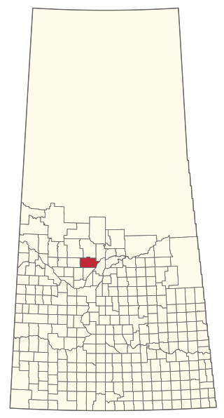
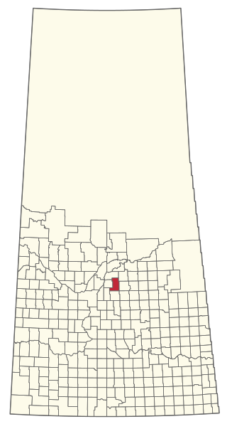
The Rural Municipality of McKillop No. 220 is a rural municipality (RM) in the Canadian province of Saskatchewan within Census Division No. 6 and SARM Division No. 2.

<span class="mw-page-title-main">Rural Municipality of Enterprise No. 142</span> Rural municipality in Saskatchewan, Canada

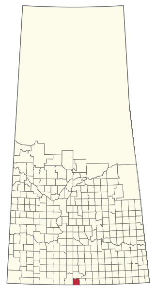
The Rural Municipality of Enterprise No. 142 is a rural municipality (RM) in the Canadian province of Saskatchewan within Census Division No. 8 and SARM Division No. 3. It is located in the southwest portion of the province.

<span class="mw-page-title-main">Rural Municipality of Wilton No. 472</span> Rural municipality in Saskatchewan, Canada

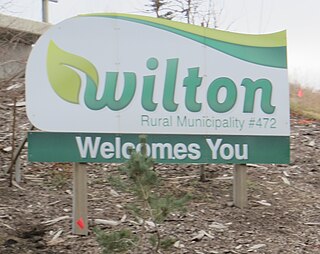
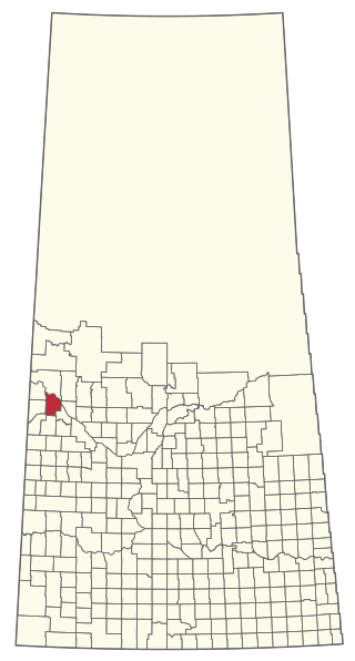
The Rural Municipality of Wilton No. 472 is a rural municipality (RM) in the Canadian province of Saskatchewan within Census Division No. 17 and SARM Division No. 6. It is located in the west-central portion of the province.

<span class="mw-page-title-main">Rural Municipality of Eldon No. 471</span> Rural municipality in Saskatchewan, Canada

The Rural Municipality of Eldon No. 471 is a rural municipality (RM) in the Canadian province of Saskatchewan within Census Division No. 17 and SARM Division No. 6.

<span class="mw-page-title-main">Rural Municipality of Lac Pelletier No. 107</span> Rural municipality in Saskatchewan, Canada

The Rural Municipality of Lac Pelletier No. 107 is a rural municipality (RM) in the Canadian province of Saskatchewan within Census Division No. 4 and SARM Division No. 3. It is located in the southwest portion of the province.

<span class="mw-page-title-main">Rural Municipality of Spy Hill No. 152</span> Rural municipality in Saskatchewan, Canada

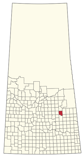
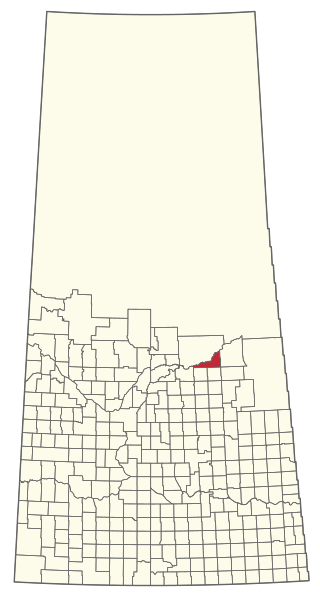
The Rural Municipality of Spy Hill No. 152 is a rural municipality (RM) in the Canadian province of Saskatchewan within Census Division No. 5 and SARM Division No. 1. It is located in the east-central portion of the province.

<span class="mw-page-title-main">Rural Municipality of Poplar Valley No. 12</span> Rural municipality in Saskatchewan, Canada

The Rural Municipality of Poplar Valley No. 12 is a rural municipality (RM) in the Canadian province of Saskatchewan within Census Division No. 3 and SARM Division No. 2. It is located in the southern portion of the province. It is adjacent to the United States border, neighbouring Daniels County in Montana.

<span class="mw-page-title-main">Rural Municipality of Good Lake No. 274</span> Rural municipality in Saskatchewan, Canada

The Rural Municipality of Good Lake No. 274 is a rural municipality (RM) in the Canadian province of Saskatchewan within Census Division No. 9 and SARM Division No. 4.

<span class="mw-page-title-main">Rural Municipality of Harris No. 316</span> Rural municipality in Saskatchewan, Canada

The Rural Municipality of Harris No. 316 is a rural municipality (RM) in the Canadian province of Saskatchewan within Census Division No. 12 and SARM Division No. 5.

<span class="mw-page-title-main">Rural Municipality of Hoodoo No. 401</span> Rural municipality in Saskatchewan, Canada

The Rural Municipality of Hoodoo No. 401 is a rural municipality (RM) in the Canadian province of Saskatchewan within Census Division No. 15 and SARM Division No. 5.

<span class="mw-page-title-main">Rural Municipality of Ituna Bon Accord No. 246</span> Rural municipality in Saskatchewan, Canada

The Rural Municipality of Ituna Bon Accord No. 246 is a rural municipality (RM) in the Canadian province of Saskatchewan within Census Division No. 10 and SARM Division No. 4.

<span class="mw-page-title-main">Rural Municipality of Sasman No. 336</span> Rural municipality in Saskatchewan, Canada

The Rural Municipality of Sasman No. 336 is a rural municipality (RM) in the Canadian province of Saskatchewan within Census Division No. 10 and SARM Division No. 4.

<span class="mw-page-title-main">Rural Municipality of Meota No. 468</span> Rural municipality in Saskatchewan, Canada

The Rural Municipality of Meota No. 468 is a rural municipality (RM) in the Canadian province of Saskatchewan within Census Division No. 17 and SARM Division No. 6.

<span class="mw-page-title-main">Rural Municipality of Mervin No. 499</span> Rural municipality in Saskatchewan, Canada

The Rural Municipality of Mervin No. 499 is a rural municipality (RM) in the Canadian province of Saskatchewan within Census Division No. 17 and SARM Division No. 6.

<span class="mw-page-title-main">Rural Municipality of Nipawin No. 487</span> Rural municipality in Saskatchewan, Canada

The Rural Municipality of Nipawin No. 487 is a rural municipality (RM) in the Canadian province of Saskatchewan within Census Division No. 14 and SARM Division No. 4.

<span class="mw-page-title-main">Rural Municipality of Pleasantdale No. 398</span> Rural municipality in Saskatchewan, Canada

The Rural Municipality of Pleasantdale No. 398 is a rural municipality (RM) in the Canadian province of Saskatchewan within Census Division No. 14 and SARM Division No. 4.

References

  1. "Pre-packaged CSV files - CGN, Canada/Province/Territory (cgn_sk_csv_eng.zip)". Government of Canada. July 24, 2019. Retrieved May 23, 2020.
  2. 1 2 "Rural Municipality Incorporations (Alphabetical)". Saskatchewan Ministry of Municipal Affairs. Archived from the original on April 21, 2011. Retrieved May 9, 2020.
  3. 1 2 3 4 "Municipality Details: RM of Britannia No. 502". Government of Saskatchewan. Retrieved May 21, 2020.
  4. 1 2 3 "Population and dwelling counts, for Canada, provinces and territories, and census subdivisions (municipalities), 2016 and 2011 censuses – 100% data (Saskatchewan)". Statistics Canada. February 8, 2017. Retrieved May 1, 2020.
  5. 1 2 "Saskatchewan Rural Municipalities". Saskatchewan Government Relations and Aboriginal Affairs. Retrieved September 7, 2013.
  6. "Census Profile - Map : Britannia No. 502, Rural municipality (Census Subdivision), Saskatchewan". Statistics Canada. March 22, 2013. Retrieved September 7, 2013.
  7. "Standard Geographical Classification (SGC) 2006 – Economic Regions: 4717028 - Britannia No. 502, geographical codes and localities, 2006". Statistics Canada. March 5, 2010. Retrieved September 7, 2013.
  8. "Saskatchewan Census Population" (PDF). Saskatchewan Bureau of Statistics. Archived from the original (PDF) on September 24, 2015. Retrieved May 9, 2020.
  9. "Saskatchewan Census Population". Saskatchewan Bureau of Statistics. Retrieved May 9, 2020.
  10. "Population and dwelling counts: Canada, provinces and territories, census divisions and census subdivisions (municipalities), Saskatchewan". Statistics Canada. February 9, 2022. Retrieved April 13, 2022.
  11. "Sandy Beach Regional Park". Canadian Geographical Names Database. Government of Canada. Retrieved August 30, 2023.
  12. "Sandybeach Lake". Canadian Geographical Names Database. Government of Canada. Retrieved August 30, 2023.
  13. "Sandy Beach Regional Park". Tourism Saskatchewan. Government of Saskatchewan. Retrieved August 31, 2023.
  14. "Sandy Beach". Regional Parks of Saskatchewan. Saskatchewan Regional Parks. Retrieved August 31, 2023.
  15. "Sandy Beach Regional Park". GolfPass. Retrieved August 31, 2023.