Rural Municipality of Frenchman Butte No. 501

Last updated

Frenchman Butte No. 501
Rural Municipality of Frenchman Butte No. 501
SK RM 501 Frenchman Butte.svg
Location of the RM of Frenchman Butte No. 501 in Saskatchewan
Coordinates: 53°37′41″N109°26′46″W / 53.628°N 109.446°W / 53.628; -109.446
Country Canada
Province Saskatchewan
Census division 17
SARM division 6
Formed [1] January 1, 1954
Government
[2]
   Reeve Barbara Bonnie Mills-Midgley
  Governing bodyRM of Frenchman Butte No. 501 Council
  AdministratorMae Rotsey
  Office location Paradise Hill
Area
 (2016) [3]
  Land1,927.39 km2 (744.17 sq mi)
Population
 (2016) [3]
  Total1,494
  Density0.8/km2 (2/sq mi)
Time zone CST
  Summer (DST) CST
Area code(s) 306 and 639

The Rural Municipality of Frenchman Butte No. 501 (2016 population: 1,494) is a rural municipality (RM) in the Canadian province of Saskatchewan within Census Division No. 17 and SARM Division No. 6.

Contents

History

The RM of Frenchman Butte No. 501 incorporated as a rural municipality on January 1, 1954. [1] It was formed through the amalgamation of the RMs of Paradise Hill No. 501 and North Star No. 531 on December 31, 1953.[ citation needed ]

Geography

Communities and localities

The following urban municipalities are surrounded by the RM.

Towns
Villages

The following unincorporated communities are within the RM.

Organized hamlets [4]
Localities

The RM also surrounds Seekaskootch First Nation Indian Reserve No. 119 and borders Makaoo 120. [5]

Deer Creek Recreation Site

Deer Creek Recreation Site ( 53°31′16″N109°37′11″W / 53.5212°N 109.6197°W / 53.5212; -109.6197 ) [6] is a provincial recreation park along the banks of the North Saskatchewan River. It is adjacent to Deer Creek Bridge, which carries Highway 3 across the river. The park is on both sides of the river with the north side being in the RM of Frenchman Butte and the southern side in the RM of Britannia. Deer Creek Recreation Site is 14 hectares (35 acres) in size, has access to the river for fishing and boating, and has a rustic campground. [7] [8]

Demographics

Population history
(1981–2016)
YearPop.±%
19811,504    
19861,537+2.2%
19911,397−9.1%
1996 1,331−4.7%
2001 1,322−0.7%
2006 1,223−7.5%
2011 1,438+17.6%
2016 1,494+3.9%
Source: Statistics Canada via Saskatchewan Bureau of Statistics [9] [10]

In the 2021 Census of Population conducted by Statistics Canada, the RM of Frenchman Butte No. 501 had a population of 1,250 living in 406 of its 503 total private dwellings, a change of

In the 2016 Census of Population, the RM of Frenchman Butte No. 501 recorded a population of 1,494 living in 455 of its 544 total private dwellings, a

Government

The RM of Frenchman Butte No. 501 is governed by an elected municipal council and an appointed administrator that meets on the second Thursday of every month. [2] The reeve of the RM is Barbara Bonnie Mills-Midgley while its administrator is Mae Rotsey. [2] The RM's office is located in Paradise Hill. [2]

Transportation

Rail [12]
Roads [13]

See also

Related Research Articles

<span class="mw-page-title-main">Division No. 17, Saskatchewan</span> Census division in Saskatchewan in Canada

Division No. 17 is one of eighteen census divisions in the province of Saskatchewan, Canada, as defined by Statistics Canada. It is located in the west-northwest part of the province, bordering Alberta. The most populous community in this division is the interprovincial city of Lloydminster. Another important population centre is the town of Meadow Lake.

<span class="mw-page-title-main">St. Walburg, Saskatchewan</span> Town in Saskatchewan, Canada

St. Walburg is a town in west-central Saskatchewan's prairie region on Highway 26. St. Walburg is surrounded by the Rural Municipality of Frenchman Butte No. 501. The Bronson Provincial Forest is about 10 kilometres (6.2 mi) to the north.

Highway 3 is a major provincial paved undivided highway in the Canadian province of Saskatchewan. It runs from the Alberta border, where it continues west as Alberta Highway 45, to the Manitoba border, and then continues east as Highway 77. Highway 3 is about 615 km (382 mi.) long. The CanAm Highway comprises Saskatchewan Highways 35, 39, 6, 3, as well as 2. 59.7 miles (96.1 km) of Saskatchewan Highway 3 contribute to the CanAm Highway between Melfort and Prince Albert.

<span class="mw-page-title-main">Rural Municipality of Canwood No. 494</span> Rural municipality in Saskatchewan, Canada

The Rural Municipality of Canwood No. 494 is a rural municipality (RM) in the Canadian province of Saskatchewan within Census Division No. 16 and SARM Division No. 5. The RM is located in the north-central portion of the province, west of the city of Prince Albert.

<span class="mw-page-title-main">Rural Municipality of Hudson Bay No. 394</span> Rural municipality in Saskatchewan, Canada

The Rural Municipality of Hudson Bay No. 394 is a rural municipality (RM) in the Canadian province of Saskatchewan within Census Division No. 14 and SARM Division No. 4. At 12,462 km2 (4,812 sq mi) in area, it is the largest rural municipality in Saskatchewan. It is in the northeast-central portion of the province.

<span class="mw-page-title-main">Turtleford</span> Town in Saskatchewan, Canada

Turtleford is a town in the rural municipality of Mervin No. 499, in the Canadian province of Saskatchewan. Turtleford is located on Highway 26 near the intersection / concurrency with Highway 3 and Highway 303. The nearest large communities are North Battleford and Lloydminster. The Turtle River runs through Turtleford, and nearby are Bright Sand Lake and Turtle Lake.

<span class="mw-page-title-main">Rural Municipality of Reno No. 51</span> Rural Municipality in Saskatchewan, Canada

The Rural Municipality of Reno No. 51 is a rural municipality (RM) in the Canadian province of Saskatchewan within Census Division No. 4 and SARM Division No. 3. Located in the southwest corner of the province, it is adjacent to the United States border to the south and the Alberta boundary to the west.

<span class="mw-page-title-main">Rural Municipality of Val Marie No. 17</span> Rural Municipality in Saskatchewan, Canada

The Rural Municipality of Val Marie No. 17 is a rural municipality (RM) in the Canadian province of Saskatchewan within Census Division No. 4 and SARM Division No. 3. Located in the southwest portion of the province, it is adjacent to the United States border, neighbouring Phillips County in Montana.

<span class="mw-page-title-main">Rural Municipality of Wise Creek No. 77</span> Rural Municipality in Saskatchewan, Canada

The Rural Municipality of Wise Creek No. 77 is a rural municipality (RM) in the Canadian province of Saskatchewan within Census Division No. 4 and SARM Division No. 3. It is located in the southwest portion of the province near Admiral.

<span class="mw-page-title-main">Rural Municipality of Barrier Valley No. 397</span> Rural Municipality in Saskatchewan, Canada

The Rural Municipality of Barrier Valley No. 397 is a rural municipality (RM) in the Canadian province of Saskatchewan within Census Division No. 14 and SARM Division No. 4. It is located in the east-central portion of the province.

Paradise Hill is a village in the Canadian province of Saskatchewan within the Rural Municipality of Frenchman Butte No. 501 and Census Division No. 17.

<span class="mw-page-title-main">Rural Municipality of Britannia No. 502</span> Rural municipality in Saskatchewan, Canada

The Rural Municipality of Britannia No. 502 is a rural municipality (RM) in the Canadian province of Saskatchewan within Census Division No. 17 and SARM Division No. 6. It is located in the west-central portion of the province.

<span class="mw-page-title-main">Rural Municipality of North Battleford No. 437</span> Rural Municipality in Saskatchewan, Canada

The Rural Municipality of North Battleford No. 437 is a rural municipality (RM) in the Canadian province of Saskatchewan within Census Division No. 16 and SARM Division No. 6. Located in the west-central portion of the province, it comprises the rural area generally to the north and east of the City of North Battleford.

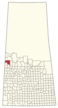
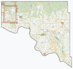
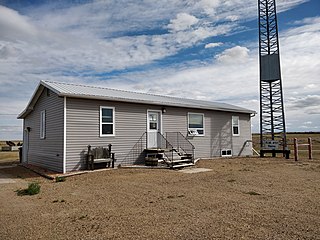
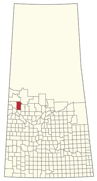
Frenchman Butte is an organized hamlet within the Rural Municipality of Frenchman Butte No. 501 in the Canadian province of Saskatchewan. It is also recognized as a designated place by Statistics Canada. Frenchman Butte is along Highway 797 on the north shore of the North Saskatchewan River approximately 43 km (27 mi) northeast of the City of Lloydminster.

<span class="mw-page-title-main">Rural Municipality of Hart Butte No. 11</span> Rural Municipality in Saskatchewan, Canada

The Rural Municipality of Hart Butte No. 11 is a rural municipality (RM) in the Canadian province of Saskatchewan within Census Division No. 3 and SARM Division No. 2. Located in the south-central portion of the province, it is adjacent to the United States boundary, neighbouring Daniels County in Montana.

<span class="mw-page-title-main">Rural Municipality of Willow Creek No. 458</span> Rural Municipality in Saskatchewan, Canada

The Rural Municipality of Willow Creek No. 458 is a rural municipality (RM) in the Canadian province of Saskatchewan within Census Division No. 14 and SARM Division No. 4.

<span class="mw-page-title-main">Rural Municipality of Fish Creek No. 402</span> Rural Municipality in Saskatchewan, Canada

The Rural Municipality of Fish Creek No. 402 is a rural municipality (RM) in the Canadian province of Saskatchewan within Census Division No. 15 and SARM Division No. 5.

<span class="mw-page-title-main">Rural Municipality of Loon Lake No. 561</span> Rural Municipality in Saskatchewan, Canada

The Rural Municipality of Loon Lake No. 561 is a rural municipality (RM) in the Canadian province of Saskatchewan within Census Division No. 17 and SARM Division No. 6.

<span class="mw-page-title-main">Rural Municipality of Meota No. 468</span> Rural municipality in Saskatchewan, Canada

The Rural Municipality of Meota No. 468 is a rural municipality (RM) in the Canadian province of Saskatchewan within Census Division No. 17 and SARM Division No. 6.

<span class="mw-page-title-main">Rural Municipality of Mervin No. 499</span> Rural Municipality in Saskatchewan, Canada

The Rural Municipality of Mervin No. 499 is a rural municipality (RM) in the Canadian province of Saskatchewan within Census Division No. 17 and SARM Division No. 6.

References

  1. 1 2 "Rural Municipality Incorporations (Alphabetical)". Saskatchewan Ministry of Municipal Affairs. Archived from the original on April 21, 2011. Retrieved May 9, 2020.
  2. 1 2 3 4 "Municipality Details: RM of Frenchman Butte No. 501". Government of Saskatchewan. Retrieved May 21, 2020.
  3. 1 2 3 "Population and dwelling counts, for Canada, provinces and territories, and census subdivisions (municipalities), 2016 and 2011 censuses – 100% data (Saskatchewan)". Statistics Canada. February 8, 2017. Retrieved May 1, 2020.
  4. "2019-2020 Rural Revenue Sharing Organized Hamlet Grant". Government of Saskatchewan. Retrieved May 4, 2020.
  5. Municipal Relations Division - RM Boundary Changes Archived 2008-01-25 at the Wayback Machine
  6. "Deer Creek Recreation Site". Canadian Geographical Names Database. Government of Canada. Retrieved August 6, 2023.
  7. https://www.brmbmaps.com/explore/canada/saskatchewan/frenchman-butte-no-501/deer-creek-recreation-site/82312
  8. https://www.mindat.org/feature-5937154.html
  9. "Saskatchewan Census Population" (PDF). Saskatchewan Bureau of Statistics. Archived from the original (PDF) on September 24, 2015. Retrieved May 9, 2020.
  10. "Saskatchewan Census Population". Saskatchewan Bureau of Statistics. Retrieved May 9, 2020.
  11. "Population and dwelling counts: Canada, provinces and territories, census divisions and census subdivisions (municipalities), Saskatchewan". Statistics Canada. February 9, 2022. Retrieved April 13, 2022.
  12. Canadian Maps: January 1925 Waghorn's Guide. Post Offices in Man. Sask. Alta. and West Ontario.
  13. Eversoft Streets and Trips