Reno No. 51 RM of Reno | |
---|---|
Rural Municipality of Reno No. 51 | |
Coordinates: 49°20′31″N109°33′04″W / 49.342°N 109.551°W [1] | |
Country | Canada |
Province | Saskatchewan |
Census division | 4 |
SARM division | 3 |
Federal riding | Cypress Hills—Grasslands |
Provincial riding | Cypress Hills |
Formed [2] | December 11, 1911 |
Government | |
• Reeve | Brian McMillan |
• Governing body | RM of Reno No. 51 Council |
• Administrator | Tanya Howell |
• Office location | Consul |
Area (2016) [4] | |
• Land | 3,461.61 km2 (1,336.54 sq mi) |
Population (2021) [4] | |
• Total | 343 |
• Density | 0.1/km2 (0.3/sq mi) |
Time zone | CST |
• Summer (DST) | CST |
Postal code | S0N 0P0 |
Area code(s) | 306 and 639 |
Highway(s) | Highway 13 Highway 18 Highway 21 Highway 615 |
Waterway(s) | Cypress Lake Battle Creek |
The Rural Municipality of Reno No. 51 (2021 population: 343) is a rural municipality (RM) in the Canadian province of Saskatchewan within Census Division No. 4 and SARM Division No. 3. Located in the southwest corner of the province, it is adjacent to the United States border to the south and the Alberta boundary to the west.
The RM of Reno No. 51 incorporated as a rural municipality on December 11, 1911. [2] Reno, Nevada and Reno County, Kansas are both named for Jesse Lee Reno, a Union general in the American Civil War. However, no record exists of why the Saskatchewan RM's name might derive from this source. An alternative explanation is that RENO is an acronym of four rural post offices in the vicinity - Russthorn (near Robsart), Eden Valley (southwest of Cypress Lake), Nashlyn (south of Consul), and Oxarat (west of Cypress Lake). Although Nashlyn then lay outside the boundary of the RM, similar acronymic names are not unknown on the Canadian prairies; see also Sangudo, Alberta. [5]
The RM of Reno No. 51 is in the southwest corner of the province. It neighbours Hill County and Blaine County in Montana to the south and Cypress County in Alberta to the west. Within Saskatchewan, it is adjacent to the RMs of Maple Creek No. 111, White Valley No. 49, and Frontier No. 19.
The following urban municipalities are surrounded by the RM.
The following unincorporated communities are located in the RM.
Climate data for WILLOW CREEK, SK (~Southwestern Reno No. 51, 1971-2000 Normals) | |||||||||||||
---|---|---|---|---|---|---|---|---|---|---|---|---|---|
Month | Jan | Feb | Mar | Apr | May | Jun | Jul | Aug | Sep | Oct | Nov | Dec | Year |
Average high °C (°F) | −5.4 (22.3) | −1.6 (29.1) | 4.8 (40.6) | 13.5 (56.3) | 19.3 (66.7) | 24.1 (75.4) | 27.8 (82.0) | 27.7 (81.9) | 20.9 (69.6) | 13.3 (55.9) | 2.3 (36.1) | −3.3 (26.1) | 12 (54) |
Average low °C (°F) | −17.8 (0.0) | −14.4 (6.1) | −7.8 (18.0) | −1.8 (28.8) | 3.9 (39.0) | 8.3 (46.9) | 10.6 (51.1) | 9.8 (49.6) | 3.8 (38.8) | −2.2 (28.0) | −10 (14) | −16.1 (3.0) | −2.8 (27.0) |
Average precipitation mm (inches) | 12.4 (0.49) | 7.8 (0.31) | 16 (0.6) | 15.6 (0.61) | 47.1 (1.85) | 60.6 (2.39) | 41.3 (1.63) | 30.9 (1.22) | 32.3 (1.27) | 16.3 (0.64) | 17 (0.7) | 16.6 (0.65) | 313.8 (12.35) |
Source: Environment Canada [8] |
In the 2021 Census of Population conducted by Statistics Canada, the RM of Reno No. 51 had a population of 343 living in 144 of its 175 total private dwellings, a change of -9.5% from its 2016 population of 379. With a land area of 3,424.73 km2 (1,322.30 sq mi), it had a population density of 0.1/km2 (0.3/sq mi) in 2021. [11]
In the 2016 Census of Population, the RM of Reno No. 51 recorded a population of 379 living in 156 of its 179 total private dwellings, a -5% change from its 2011 population of 399. With a land area of 3,461.61 km2 (1,336.54 sq mi), it had a population density of 0.1/km2 (0.3/sq mi) in 2016. [12]
Govenlock-Nashlyn-Battle Creek Grasslands (SK 039) is an Important Bird Area (IBA) of Canada [13] located at the south-western corner of the RM of Reno. It is a rectangular-shaped IBA site with the southern boundary running along the border with Montana. The western boundary runs up for 35 kilometres (22 mi) along the border with Alberta and the northern boundary extends towards the communities of Govenlock and Nashlyn and Battle Creek. From Nashlyn, it heads straight south back to the U.S. border. The site totals 840.03 km2 (324.34 sq mi) and has an elevation range of 903 to 1,001 metres. Access is from Highway 21.
The landscape of Govenlock-Nashlyn-Battle Creek Grasslands consists of large expanses of native grassland and rugged valleys with steep cliffs and cut banks. Originating from the Cypress Hills to the north, several of the streams that run through the site have been dammed to provide water for cattle. McRae, Lodge, and Middle Creeks are the primary waterways through the site while Battle Creek skirts the north-eastern edge. A variety of birds are found in the IBA, including the sage grouse, prairie falcon, golden eagle, ferruginous hawk, violet-green swallow, burrowing owl, rock wren, short-eared owl, sage thrasher, rough-legged hawk, long-billed curlew, Sprague's pipit, Baird's sparrow, Brewer's sparrow, chestnut-collared longspur, McCown's longspur, and the Bullock's oriole. The creeks and dams also provide important habit for fawning and wintering pronghorn. [14]
The RM of Reno No. 51 is governed by an elected municipal council and an appointed administrator that meets on the second Wednesday of every month. [3] The reeve of the RM is Brian McMillan while its administrator is Tanya Howell. [3] The RM's office is located in Consul. [3]
The following is a list of Saskatchewan highways, railways, and other forms of transportation that service the area.
Battle Creek is a river that begins in the south-eastern region of the Canadian province of Alberta, near the border with Saskatchewan, in the Cypress Hills Interprovincial Park. From Alberta, Battle Creek flows east and across the border into Saskatchewan. It flows south out of Saskatchewan across the Canada–United States border into Montana, where it joins the Milk River in Blaine County, Montana.
The Rural Municipality of Abernethy No. 186 is a rural municipality (RM) in the Canadian province of Saskatchewan within Census Division No. 6 and SARM Division No. 1. It is located on the Qu'Appelle River.
Maple Creek is a town in the Cypress Hills of southwest Saskatchewan, Canada. It is surrounded by the Rural Municipality of Maple Creek No. 111. The population was 2,176 at the 2021 Census.
Division No. 4 is one of eighteen census divisions in the province of Saskatchewan, Canada, as defined by Statistics Canada. It is located in the southwest corner of the province, bordering Alberta to the west and Montana, United States to the south. The most populous community in this division is Maple Creek.
The Rural Municipality of Antelope Park No. 322 is a rural municipality (RM) in the Canadian province of Saskatchewan within Census Division No. 13 and SARM Division No. 6. It is located along the border with Alberta.
The Rural Municipality of Heart's Hill No. 352 is a rural municipality (RM) in the Canadian province of Saskatchewan within Census Division No. 13 and SARM Division No. 6. Located in the west-central portion of the province, it is adjacent to the Alberta boundary.
The Rural Municipality of Eye Hill No. 382 is a rural municipality (RM) in the Canadian province of Saskatchewan within Census Division No. 13 and SARM Division No. 6. It is located in the west-central portion of the province adjacent to the Alberta boundary.
The Rural Municipality of Senlac No. 411 is a rural municipality (RM) in the Canadian province of Saskatchewan within Census Division No. 13 and SARM Division No. 6. Located in the west-central portion of the province, it is adjacent to the Alberta boundary.
The Rural Municipality of Milton No. 292 is a rural municipality (RM) in the Canadian province of Saskatchewan within Census Division No. 13 and SARM Division No. 6. Located in the west-central portion of the province, it is adjacent to the Alberta boundary.
The Rural Municipality of Frenchman Butte No. 501 is a rural municipality (RM) in the Canadian province of Saskatchewan within Census Division No. 17 and SARM Division No. 6.
The Rural Municipality of Happyland No. 231 is a rural municipality (RM) in the Canadian province of Saskatchewan within Census Division No. 8 and SARM Division No. 3. Located in the southwest portion of the province, it is adjacent to the Alberta boundary and south of the South Saskatchewan River.
The Rural Municipality of Blaine Lake No. 434 is a rural municipality (RM) in the Canadian province of Saskatchewan within Census Division No. 16 and SARM Division No. 5. The RM extends east to the North Saskatchewan River and north to the village of Marcelin.
Robsart is an unincorporated hamlet within the rural municipality of Reno No. 51, in the province of Saskatchewan, Canada. Robsart had a population of 20 at the 2016 Canada Census. Robsart previously incorporated an independent village since 1912 until it was dissolved into an unincorporated community on January 1, 2002 under the jurisdiction of the rural municipality of Reno No. 51. Robsart is located 48 km southwest of the town of Eastend at the junction of Highway 18 and Highway 13 approximately 170 km south-east of Medicine Hat, Alberta, 68 km south of the Town of Maple Creek.
The Rural Municipality of Deer Forks No. 232 is a rural municipality (RM) in the Canadian province of Saskatchewan within Census Division No. 8 and SARM Division No. 3. Located in the southwest portion of the province, it is adjacent to the Alberta boundary, neighbouring Cypress County to the west.
The Rural Municipality of Wise Creek No. 77 is a rural municipality (RM) in the Canadian province of Saskatchewan within Census Division No. 4 and SARM Division No. 3. It is located in the southwest portion of the province near Admiral.
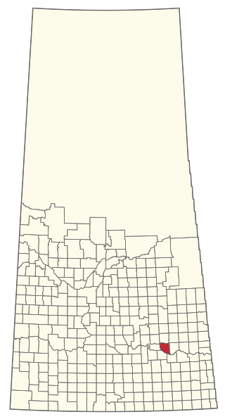
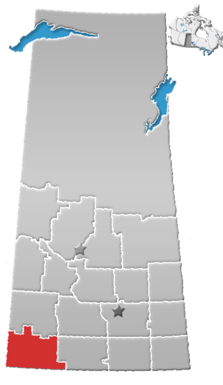
The Rural Municipality of Excel No. 71 is a rural municipality (RM) in the Canadian province of Saskatchewan within Census Division No. 3 and SARM Division No. 2. It is located in the south-central portion of the province.
The Rural Municipality of Chesterfield No. 261 is a rural municipality (RM) in the Canadian province of Saskatchewan within Census Division No. 8 and SARM Division No. 3.
The Rural Municipality of Fish Creek No. 402 is a rural municipality (RM) in the Canadian province of Saskatchewan within Census Division No. 15 and SARM Division No. 5.
The Rural Municipality of Mount Hope No. 279 is a rural municipality (RM) in the Canadian province of Saskatchewan within Census Division No. 10 and SARM Division No. 5.
The Rural Municipality of Milden No. 286 is a rural municipality (RM) in the Canadian province of Saskatchewan within Census Division No. 12 and SARM Division No. 5.