Rural Municipality of Pittville No. 169

Last updated

Pittville No. 169
Rural Municipality of Pittville No. 169
SK RM 169 Pittville.svg
Location of the RM of Pittville No. 169 in Saskatchewan
Coordinates: 50°26′53″N108°44′28″W / 50.448°N 108.741°W / 50.448; -108.741 [1]
Country Canada
Province Saskatchewan
Census division 8
SARM division 3
Formed [2] January 1, 1913
Government
[3]
   Reeve Larry Sletten
  Governing bodyRM of Pittville No. 169 Council
  AdministratorTerry Erdelyan
  Office location Hazlet
Area
 (2016) [4]
  Land1,258.06 km2 (485.74 sq mi)
Population
 (2016) [4]
  Total208
  Density0.2/km2 (0.5/sq mi)
Time zone CST
  Summer (DST) CST
Postal code
S0N 1E0
Area code(s) 306 and 639
Highway(s) Highway 332

The Rural Municipality of Pittville No. 169 (2016 population: 208) is a rural municipality (RM) in the Canadian province of Saskatchewan within Census Division No. 8 and SARM Division No. 3. Located in the southwest portion of the province, it is northwest of the town of Gull Lake.

Contents

History

The RM of Pittville No. 169 incorporated as a rural municipality on January 1, 1913. [2]

Geography

Communities and localities

The following urban municipalities are surrounded by the RM.

Villages

The following unincorporated communities are located in the RM.

Localities

Parks and recreation

Demographics

Population history
(1981–2016)
YearPop.±%
1981406    
1986356−12.3%
1991309−13.2%
1996 291−5.8%
2001 272−6.5%
2006 216−20.6%
2011 204−5.6%
2016 208+2.0%
Source: Statistics Canada via Saskatchewan Bureau of Statistics [5] [6]

In the 2021 Census of Population conducted by Statistics Canada, the RM of Pittville No. 169 had a population of 201 living in 81 of its 93 total private dwellings, a change of

In the 2016 Census of Population, the RM of Pittville No. 169 recorded a population of 208 living in 82 of its 107 total private dwellings, a

Government

The RM of Pittville No. 169 is governed by an elected municipal council and an appointed administrator that meets on the second Tuesday of every month. [3] The reeve of the RM is Larry Sletten while its administrator is Terry Erdelyan. [3] The RM's office is located in Hazlet. [3]

Standing Rock

Standing Rock ( 50°23′40″N108°41′09″W / 50.3944°N 108.6857°W / 50.3944; -108.6857 ) is a large glacial erratic left from the last ice age around 14,000 years ago. It is composed of granite from the Hudson Bay area and is 3.35 m (11.0 ft) high and 9.14 m (30.0 ft) long. It is about 6 kilometres (3.7 mi) west of Hazlet along Highway 332. It was used as a scratching post for bison for centuries, and as a landmark by First Nations and later on by early settlers. It is a recorded petrograph site and is now a historical site. [8] [9]

Transportation

Highways within the RM include:

See also

Related Research Articles

<span class="mw-page-title-main">Rural Municipality of Eyebrow No. 193</span> Rural municipality in Saskatchewan, Canada

The Rural Municipality of Eyebrow No. 193 is a rural municipality (RM) in the Canadian province of Saskatchewan within Census Division No. 7 and SARM Division No. 2. It is located in the south-central portion of the province.

<span class="mw-page-title-main">Rural Municipality of Hudson Bay No. 394</span> Rural municipality in Saskatchewan, Canada

The Rural Municipality of Hudson Bay No. 394 is a rural municipality (RM) in the Canadian province of Saskatchewan within Census Division No. 14 and SARM Division No. 4. At 12,462 km2 (4,812 sq mi) in area, it is the largest rural municipality in Saskatchewan. It is in the northeast-central portion of the province.

<span class="mw-page-title-main">Rural Municipality of Arlington No. 79</span> Rural municipality in Saskatchewan, Canada

The Rural Municipality of Arlington No. 79 is a rural municipality (RM) in the Canadian province of Saskatchewan within Census Division No. 4 and SARM Division No. 3. It is located in the southwestern region of the province east of Shaunavon.

<span class="mw-page-title-main">Rural Municipality of Bone Creek No. 108</span> Rural municipality in Saskatchewan, Canada

The Rural Municipality of Bone Creek No. 108 is a rural municipality (RM) in the Canadian province of Saskatchewan within Census Division No. 4 and SARM Division No. 3. It is located in the southwest portion of the province.

<span class="mw-page-title-main">Rural Municipality of Deer Forks No. 232</span> Rural municipality in Saskatchewan, Canada

The Rural Municipality of Deer Forks No. 232 is a rural municipality (RM) in the Canadian province of Saskatchewan within Census Division No. 8 and SARM Division No. 3. Located in the southwest portion of the province, it is adjacent to the Alberta boundary, neighbouring Cypress County to the west.

<span class="mw-page-title-main">Rural Municipality of Barrier Valley No. 397</span> Rural municipality in Saskatchewan, Canada

The Rural Municipality of Barrier Valley No. 397 is a rural municipality (RM) in the Canadian province of Saskatchewan within Census Division No. 14 and SARM Division No. 4. It is located in the east-central portion of the province.

<span class="mw-page-title-main">Rural Municipality of Lawtonia No. 135</span> Rural municipality in Saskatchewan, Canada

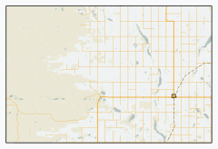
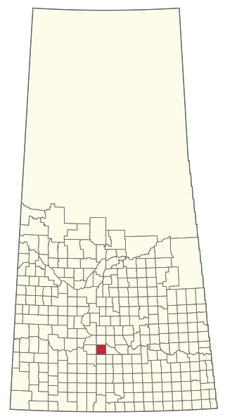
The Rural Municipality of Lawtonia No. 135 is a rural municipality (RM) in the Canadian province of Saskatchewan within Census Division No. 7 and SARM Division No. 3.

<span class="mw-page-title-main">Rural Municipality of Mankota No. 45</span> Rural municipality in Saskatchewan, Canada

The Rural Municipality of Mankota No. 45 is a rural municipality (RM) in the Canadian province of Saskatchewan within SARM Division No. 3. Located in the southwest portion of the province, it is adjacent to the United States border, neighbouring Valley County and Phillips County in Montana.

<span class="mw-page-title-main">Rural Municipality of Riverside No. 168</span> Rural municipality in Saskatchewan, Canada

The Rural Municipality of Riverside No. 168 is a rural municipality (RM) in the Canadian province of Saskatchewan within Census Division No. 8 and SARM Division No. 3.

<span class="mw-page-title-main">Rural Municipality of Cote No. 271</span> Rural municipality in Saskatchewan, Canada

The Rural Municipality of Cote No. 271 is a rural municipality (RM) in the Canadian province of Saskatchewan within Census Division No. 9 and SARM Division No. 4.

<span class="mw-page-title-main">Rural Municipality of Grass Lake No. 381</span> Rural municipality in Saskatchewan, Canada

The Rural Municipality of Grass Lake No. 381 is a rural municipality (RM) in the Canadian province of Saskatchewan within Census Division No. 13 and SARM Division No. 6.

<span class="mw-page-title-main">Rural Municipality of Kellross No. 247</span> Rural municipality in Saskatchewan, Canada

The Rural Municipality of Kellross No. 247 is a rural municipality (RM) in the Canadian province of Saskatchewan within Census Division No. 10 and SARM Division No. 4.

<span class="mw-page-title-main">Rural Municipality of King George No. 256</span> Rural municipality in Saskatchewan, Canada

The Rural Municipality of King George No. 256 is a rural municipality (RM) in the Canadian province of Saskatchewan within Census Division No. 7 and SARM Division No. 3.

<span class="mw-page-title-main">Rural Municipality of Tramping Lake No. 380</span> Rural municipality in Saskatchewan, Canada

The Rural Municipality of Tramping Lake No. 380 is a rural municipality (RM) in the Canadian province of Saskatchewan within Census Division No. 13 and SARM Division No. 6.

<span class="mw-page-title-main">Rural Municipality of Touchwood No. 248</span> Rural municipality in Saskatchewan, Canada

The Rural Municipality of Touchwood No. 248 is a rural municipality (RM) in the Canadian province of Saskatchewan within Census Division No. 10 and SARM Division No. 4.

<span class="mw-page-title-main">Rural Municipality of Rudy No. 284</span> Rural municipality in Saskatchewan, Canada

The Rural Municipality of Rudy No. 284 is a rural municipality (RM) in the Canadian province of Saskatchewan within Census Division No. 11 and SARM Division No. 5.

<span class="mw-page-title-main">Rural Municipality of Livingston No. 331</span> Rural municipality in Saskatchewan, Canada

The Rural Municipality of Livingston No. 331 is a rural municipality (RM) in the Canadian province of Saskatchewan within Census Division No. 9 and SARM Division No. 4.

<span class="mw-page-title-main">Rural Municipality of Loon Lake No. 561</span> Rural municipality in Saskatchewan, Canada

The Rural Municipality of Loon Lake No. 561 is a rural municipality (RM) in the Canadian province of Saskatchewan within Census Division No. 17 and SARM Division No. 6.

<span class="mw-page-title-main">Rural Municipality of Medstead No. 497</span> Rural municipality in Saskatchewan, Canada

The Rural Municipality of Medstead No. 497 is a rural municipality (RM) in the Canadian province of Saskatchewan within Census Division No. 16 and SARM Division No. 6.

<span class="mw-page-title-main">Rural Municipality of Pleasant Valley No. 288</span> Rural municipality in Saskatchewan, Canada

The Rural Municipality of Pleasant Valley No. 288 is a rural municipality (RM) in the Canadian province of Saskatchewan within Census Division No. 12 and SARM Division No. 6.

References

  1. "Pre-packaged CSV files - CGN, Canada/Province/Territory (cgn_sk_csv_eng.zip)". Government of Canada. July 24, 2019. Retrieved May 23, 2020.
  2. 1 2 "Rural Municipality Incorporations (Alphabetical)". Saskatchewan Ministry of Municipal Affairs. Archived from the original on April 21, 2011. Retrieved May 9, 2020.
  3. 1 2 3 4 "Municipality Details: RM of Pittville No. 169". Government of Saskatchewan. Retrieved May 21, 2020.
  4. 1 2 3 "Population and dwelling counts, for Canada, provinces and territories, and census subdivisions (municipalities), 2016 and 2011 censuses – 100% data (Saskatchewan)". Statistics Canada. February 8, 2017. Retrieved May 1, 2020.
  5. "Saskatchewan Census Population" (PDF). Saskatchewan Bureau of Statistics. Archived from the original (PDF) on September 24, 2015. Retrieved May 9, 2020.
  6. "Saskatchewan Census Population". Saskatchewan Bureau of Statistics. Retrieved May 9, 2020.
  7. "Population and dwelling counts: Canada, provinces and territories, census divisions and census subdivisions (municipalities), Saskatchewan". Statistics Canada. February 9, 2022. Retrieved April 13, 2022.
  8. Baird, Craig (May 18, 2022). "The History of Hazlet". Canadian History Ehx. Meks. Retrieved January 26, 2023.
  9. "Standing Rock Natural Phenomenon". Tourism Saskatchewan. Government of Saskatchewan. Retrieved January 26, 2023.