Eatonia

Last updated

Eatonia
Town of Eatonia
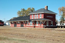
Eatonia train station 2007.jpg
Former Canadian National Railway station in Eatonia
Chesterfield No. 261 Coloured Map.svg
Red pog.svg
Eatonia
Canada Saskatchewan location map.svg
Red pog.svg
Eatonia
Coordinates: 51°13′16″N109°23′26″W / 51.22111°N 109.39056°W / 51.22111; -109.39056
CountryCanada
Province Saskatchewan
Census division 8
Rural Municipality Chesterfield
Founded1919
Incorporated1954
Government
   Mayor (?) [1]
  AdministratorCheryl Bailey
  Governing bodyEatonia Town Council
Area
  Total1.68 km2 (0.65 sq mi)
Elevation
719.6 m (2,360.9 ft)
Population
 (2006)
  Total449
  Density266.6/km2 (690/sq mi)
Time zone CST
Postal code
S0L 0Y0
Area code 306
Highways 21 and 44
Airport Eatonia (Elvie Smith) Municipal
Website eatonia.ca
[2] [3]

Eatonia is a town in the Canadian province of Saskatchewan with a population of 449 people (according to the Canada 2006 Census). [4] The town's economy is based almost exclusively on agriculture. Eatonia is in southwest Saskatchewan at the crossroads of Highways 21 and 44, approximately 44 kilometres southwest of Kindersley and 72 kilometres from the provincial boundary with Alberta. The town is served by Eatonia (Elvie Smith) Municipal Airport.

Contents

History

The town of Eaton, later Eatonia, in 1920 Eatonia postcard 1920.jpg
The town of Eaton, later Eatonia, in 1920
Eatonia in 1935 Eatonia 1935.JPG
Eatonia in 1935

Eatonia was founded in 1919 as a station on the Canadian National Railway and was named after Timothy Eaton, founder of the Eaton's department store chain and catalogue, and to honour his son and heir, John Craig Eaton. The station was originally simply called "Eaton", but there was confusion with nearby Eston, so the name was changed to Eatonia in 1921 ("Eatonia" was the name of an Eaton's brand for clothing and other goods, and "Eatonian" was the name given to long-serving Eaton's employees).

Eatonia was incorporated as a town in 1954. In 1955, the year of Saskatchewan's Golden Jubilee, Eatonia's train station was featured on the cover of the Eaton's catalogue, thus resulting in a classic local image finding its way into homes across the country. The former CN train station is now home to the Wheatland Regional Library (Eatonia Branch). The former station, along with a train caboose and a wood-frame house ordered from the Eaton's catalogue in 1917, comprise the Eatonia Heritage Park, a 0.6-hectare (1.5-acre) Municipal Heritage Property located at the south end of Main Street. [5]

Demographics

In the 2021 Census of Population conducted by Statistics Canada, Eatonia had a population of 498 living in 205 of its 253 total private dwellings, a change of -5% from its 2016 population of 524. With a land area of 1.6 km2 (0.62 sq mi), it had a population density of 311.3/km2 (806.1/sq mi) in 2021. [6]

Canada census – Eatonia community profile
2021 2011
Population498 (-5.0% from 2016)508 (13.1% from 2006)
Land area1.60 km2 (0.62 sq mi)1.68 km2 (0.65 sq mi)
Population density311.6/km2 (807/sq mi)301.6/km2 (781/sq mi)
Median age39.2 (M: 37.6, F: 42.8)44.5 (M: 41.8, F: 45.3)
Private dwellings253 (total)  205 (occupied)239 (total) 
Median household income$83,000
References: 2021 [7] 2011 [8] earlier [9] [10]

Education

Eatonia is home to a kindergarten to Grade 12 public school, Eaton School, which has been home to many successful volleyball, basketball, and football teams throughout its history. It is located within the Sun West School Division.

See also

Related Research Articles

<span class="mw-page-title-main">Rouleau, Saskatchewan</span> Town in Saskatchewan, Canada

Rouleau is a town in southern Saskatchewan, Canada, on the Canadian Prairies. It lies within census Division No. 6 and Rural Municipality of Redburn No. 130.

<span class="mw-page-title-main">Alsask</span> Special service area in Saskatchewan, Canada

Alsask is a special service area in the Rural Municipality of Milton No. 292, in the province of Saskatchewan, Canada. Alsask is located 60 km (37 mi) west of the town of Kindersley. Highway 44 runs to the east of Alsask, and Highway 7 lies a few kilometres to the north. The community had a population of 113 in the 2021 Canadian census.

<span class="mw-page-title-main">Balgonie</span> Town in Saskatchewan, Canada

Balgonie is a town in southeast Saskatchewan. Situated at the intersection of Highways 10, 46, and the Trans-Canada Highway, the town is part of the White Butte region and neighbours Pilot Butte, White City, and McLean. As well, it is located 25 kilometres east of the province's capital city, Regina. As of the 2016 census, Balgonie had a population of 1,765, an 8.3% growth from 2011. The town is governed by the Balgonie Town Council and is surrounded by the Rural Municipality of Edenwold No. 158. Balgonie is located in Treaty 4 territory.

<span class="mw-page-title-main">Davidson, Saskatchewan</span> Town in Saskatchewan, Canada

Davidson is a town in south central Saskatchewan, Canada. It is 104 kilometres (65 mi) south-east of Saskatoon beside provincial highway 11 as well as Highway 44, in the Rural Municipality of Arm River No. 252. Approximately halfway between Saskatoon and Regina, it is a popular stopping point with many restaurants and gas stations located adjacent to the highway.

<span class="mw-page-title-main">Wakaw</span> Town in Saskatchewan, Canada

Wakaw, Saskatchewan, is a town 90 kilometres (56 mi) northeast of Saskatoon and 66 kilometres (41 mi) south of Prince Albert. It is about halfway between the two cities and is served by Highway 2, Highway 41, and Highway 312. Wakaw is in hilly partially forested country east of the South Saskatchewan River. The area is part of the aspen parkland biome.

<span class="mw-page-title-main">Blaine Lake</span> Town in Saskatchewan, Canada

Blaine Lake is a town in central Saskatchewan, Canada. It is located 85 km north of Saskatoon, 104 km southwest of Prince Albert and 104 km east of North Battleford at the junction of Highway 12 and Highway 40. Nearby are the urban centres of Shellbrook and Rosthern. Blaine Lake is considered the "Gateway to the Northern Lakes" due to its proximity to fishing, hunting and camping sites, as well as its convenient location at a junction of two highways.

Strasbourg is a small town in the Canadian province of Saskatchewan. It is located about 75 kilometres (47 mi) northwest of the provincial capital, Regina.

<span class="mw-page-title-main">Alameda, Saskatchewan</span> Town in Saskatchewan

Alameda is a town in south-eastern Saskatchewan, Canada, approximately 50 kilometres (31 mi) east of Estevan. A translation of Alameda from Spanish is "Poplar Grove" or "Tree Lined Avenue". One popular story is that the town was named for Alameda, California although there is no written documentation to support this. Alameda had a population of 369 in the Canada Census of 2016.

<span class="mw-page-title-main">Avonlea, Saskatchewan</span> Village in Saskatchewan, Canada

Avonlea is a village in the Canadian province of Saskatchewan within the RM of Elmsthorpe No. 100 and Census Division No. 2. The village is approximately 82 kilometres (51 mi) south-west of the city of Regina. The Southern Rails Cooperative maintains its head office in the village.

<span class="mw-page-title-main">St. Walburg, Saskatchewan</span> Town in Saskatchewan, Canada

St. Walburg is a town in west-central Saskatchewan's prairie region on Highway 26. St. Walburg is surrounded by the Rural Municipality of Frenchman Butte No. 501. The Bronson Provincial Forest is about 10 kilometres (6.2 mi) to the north.

<span class="mw-page-title-main">Cudworth, Saskatchewan</span> Town in Saskatchewan, Canada

Cudworth is a town in Saskatchewan, Canada. Cudworth is located approximately 85 km north-east of Saskatoon, Saskatchewan in the Minnichinas Hills. Cudworth is in hilly partially forested country east of the South Saskatchewan River. The area is part of the aspen parkland biome.

<span class="mw-page-title-main">Bethune, Saskatchewan</span> Village in Saskatchewan, Canada

Bethune is a village in the Canadian province of Saskatchewan within the Rural Municipality of Dufferin No. 190 and Census Division No. 6. The village is 56 kilometres (35 mi) north-west of Regina on Highway 11. Arm River flows along a river valley north of Bethune, which features camping sites, and the Qu'Appelle River is a short way south. Last Mountain Lake or Long Lake is north-east of Bethune whereas Buffalo Pound Lake is just south-west.

<span class="mw-page-title-main">Bienfait</span> Town in Saskatchewan, Canada

Bienfait is a town in Saskatchewan on Highway 18 that is 14 kilometres (8.7 mi) east of Estevan. It is surrounded by the RM of Coalfields.

<span class="mw-page-title-main">Herbert, Saskatchewan</span> Town in Saskatchewan, Canada

Herbert is a town located in the Rural Municipality of Morse No. 165, in southwest Saskatchewan, Canada. The community is 48 km east of the city of Swift Current, and 197 km west of Regina, the provincial capital, on the Trans-Canada Highway. Its population as of 2016 was 856.

Kinistino is a town in the Canadian province of Saskatchewan. Kinistino is situated in north-central Saskatchewan. It lies on rich agricultural soil in the valley of the Carrot River, which flows a mile east of the town. Kinistino is located 30 kilometres (19 mi) northwest of Melfort on Highway 3 and 65 kilometres (40 mi) southeast of Prince Albert.

Porcupine Plain is a town in Saskatchewan, Canada. It is accessed by Highway 23. Greenwater Lake Provincial Park is 5 kilometres (3.1 mi) southwest on Highway 38. The town is located within the Porcupine Provincial Forest. The town was originally settled by returning World War I veterans who settled in the area during the early 1920s. Quilly Willy is the town mascot used on promotional material. Porcupine Plain is the hometown of Calgary Hitmen play-by-play man Brad Curle, St. Louis Blues alumnus Kelly Chase, Paralympic athlete Colette Bourgonje, TSN SportsCentre sportscaster Darren Dutchyshen, as well as the company Sweet Pure Honey.

<span class="mw-page-title-main">Preeceville</span> Town in Saskatchewan, Canada

Preeceville is a town in Saskatchewan, Canada. The town is 10 kilometres (6.2 mi) west of Sturgis and 99 kilometres (62 mi) north of Yorkton at the junction of Highway 49, Highway 47, Highway 9 and near Highway 755.

Lake Lenore is a village in the Canadian province of Saskatchewan within the Rural Municipality of St. Peter No. 369 and Census Division No. 15. The village is located 144 kilometres (89 mi) northeast of the city of Saskatoon. To the north of the village is Lenore Lake, which is designated as a migratory bird sanctuary, an Important Bird Area (IBA) of Canada, and has a National Wildlife Area on Raven Island. Services in Lake Lenore include a school, Co-op Grocery and Agro Service Station, a Credit Union, and Public Library.

Mantario is a special service area in the Rural Municipality of Chesterfield No. 261 in the Canadian province of Saskatchewan.It held village status prior to June 30, 2007. The population was five people in 2011. The community is located 70 kilometres (43 mi) southwest of the town of Kindersley on Highway 44.

<span class="mw-page-title-main">Rural Municipality of Chesterfield No. 261</span> Rural municipality in Saskatchewan, Canada

The Rural Municipality of Chesterfield No. 261 is a rural municipality (RM) in the Canadian province of Saskatchewan within Census Division No. 8 and SARM Division No. 3.

References

  1. "Town of Eatonia – Our progressive town is about its people". eatonia.ca. Retrieved 25 February 2024.
  2. National Archives, Archivia Net. "Post Offices and Postmasters". Archived from the original on 6 October 2006. Retrieved 6 September 2013.
  3. Government of Saskatchewan, MRD Home. "Municipal Directory System". Archived from the original on 15 January 2016. Retrieved 6 September 2013.
  4. Statistics Canada, 2006 Census [ permanent dead link ]
  5. Eatonia Heritage Park . Canadian Register of Historic Places .
  6. "Population and dwelling counts: Canada, provinces and territories, census divisions and census subdivisions (municipalities), Saskatchewan". Statistics Canada. 9 February 2022. Retrieved 1 April 2022.
  7. "2021 Community Profiles". 2021 Canadian Census . Statistics Canada. 4 February 2022. Retrieved 19 October 2023.
  8. "2011 Community Profiles". 2011 Canadian Census . Statistics Canada. 21 March 2019. Retrieved 4 August 2012.
  9. "2006 Community Profiles". 2006 Canadian Census . Statistics Canada. 20 August 2019.
  10. "2001 Community Profiles". 2001 Canadian Census . Statistics Canada. 18 July 2021.