Carnduff

Last updated

Carnduff
Town
Carnduff Saskatchewan Broadway Winter.jpg
Downtown Carnduff
Motto: 
"A community on the move"
Canada Saskatchewan location map.svg
Red pog.svg
Carnduff
Location of Carnduff
Canada location map 2.svg
Red pog.svg
Carnduff
Carnduff (Canada)
Coordinates: 49°10′01″N101°46′59″W / 49.167°N 101.783°W / 49.167; -101.783
CountryCanada
Province Saskatchewan
Rural Municipality Mount Pleasant No. 2
Post Office Established1884-09-01
Government
   Mayor Ross Apperley
  AdministratorAnnette Brown
  Governing bodyCarnduff Town Council
Area
  Total
2.26 km2 (0.87 sq mi)
Elevation
515 m (1,690 ft)
Population
 (2011)
  Total
1,126
  Density192.0/km2 (497.3/sq mi)
Time zone CST (winter) / MST (summer)
Postal code
S0C 0S0
Area code 306
Highways Saskatchewan Highway 18 (jct).svg Highway 18
[1] [2] [3]

Carnduff is a small agricultural town in southeast Saskatchewan, Canada.

Contents

History

Carnduff is named after its first postmaster, John Carnduff. It was marked on early CPR maps, though that location did not exactly correspond to the present town site later surveyed in 1891.

In 2001, the town was noted as having trees affected by Dutch Elm Disease. [4]

Geography

The town lies at the intersection of Highway 318 and Highway 18. The Canadian Pacific Railway runs parallel to Highway 18 and their combined thoroughfare splits the town into a north half and a south half. The majority of housing and businesses are in the southern half of the town, while the northern half has a majority of the recreation facilities and larger industrial buildings. The Antler River flows around the north side and east of the town, adding a small valley to the otherwise flat local flat prairie.

Traffic diversion to allow flood damage repairs to bridge Bridge flood damage repair 2011.jpg
Traffic diversion to allow flood damage repairs to bridge

Severe flooding in the Souris River basin region during the spring and summer of 2011 caused damage to bridges over the Antler River north and east of the town. Significant repair work was required on the Highway 18 bridge near the Viterra terminal.

The nearest locations with a population larger than 10,000 are Estevan 90 kilometres to the west, and Minot, North Dakota 140 Kilometres to the south-east. The provincial capital, Regina, is approximately three hours north-west by highway.

Demographics

In the 2021 Census of Population conducted by Statistics Canada, Carnduff had a population of 1,150 living in 430 of its 527 total private dwellings, a change of 4.6% from its 2016 population of 1,099. With a land area of 2.61 km2 (1.01 sq mi), it had a population density of 440.6/km2 (1,141.2/sq mi) in 2021. [5]

Canada census – Carnduff community profile
2021 2011
Population1,150 (+4.6% from 2016)1,126 (+11.3% from 2006)
Land area2.61 km2 (1.01 sq mi)2.26 km2 (0.87 sq mi)
Population density441/km2 (1,140/sq mi)497.3/km2 (1,288/sq mi)
Median age40.8 (M: 38.4, F: 42.4)37.0 (M: 35.5, F: 39.3)
Private dwellings527 (total)  430 (occupied)488 (total) 
Median household income$89,000
References: 2021 [6] 2011 [7]

Economy

Inland grain terminal located east of town Carnduff Grain Terminal Viterra 2011.jpg
Inland grain terminal located east of town

As a larger town than those adjacent to it, Carnduff is a centre of schooling and business activity in the extreme south-eastern corner of Saskatchewan. The Gazette Post News, a weekly newspaper, is based in Carnduff and reports on items from the neighbouring communities. [8]

The Saskatchewan Wheat Pool (SWP) built a concrete inland terminal on the rail line a few kilometres east of the town during the late 1990s. In 2010, SWP's successor corporation Viterra started an upgrade project that included an expansion of the rail-yard from 56 to 112 cars and a 7,000 metric ton increase in storage capacity that would result in 33,000 metric tons of capacity. [9]

Because Carnduff is located within the Bakken Formation geological zone, it is surrounded by active oil and gas drilling sites. A large number of businesses in the town are involved in the petroleum industry by providing transportation, construction, or specialized oilfield services.

Sport and recreation

Sporting sites available in Carnduff include tennis courts, an artificial-ice skating rink, a curling rink, a swimming pool, a five-pin bowling alley, and a rodeo ring. A nine-hole golf course, situated north of the town, opened its grass greens in 1982. [10] The baseball facilities were moved to the west side of town and significantly upgraded in the mid-1990s to a level where the town has hosted provincial and national level tournaments in fastpitch softball.

The Carnduff Red Devils of the senior men's Big 6 Hockey League play at the local rink. The Red Devils have won the Lincoln Trophy 10 times, second only to the Bienfait Coalers' 15. [11]

The Carnduff Astros of the Saskota Baseball League [12] and the South East Steelers softball team play at the Carnduff Ball Diamonds. [13]

Education

The Carnduff Education Complex is part of School Division SD 209 "South East Cornerstone". It opened in 2004 and consolidated two facilities in Carnduff as well as services from other surrounding towns. Students attend classes from kindergarten to Grade 12. The former Carnduff Elementary School and Carnduff High School were re-purposed, with the latter being renamed the Dean Fraser Community Centre. [14] Some schools in the area, specifically in Gainsborough and Storthoaks were closed, while the Carievale Elementary School [15] was expanded to accommodate more younger students.

Water tower at Carnduff, Saskatchewan Water tower at Carnduff Saskatchewan.jpg
Water tower at Carnduff, Saskatchewan

Notable people

See also

Related Research Articles

<span class="mw-page-title-main">Estevan</span> City in Saskatchewan, Canada

Estevan is the eleventh-largest city in Saskatchewan, Canada. It is approximately 16 kilometres (9.9 mi) north of the Canada–United States border. The Souris River runs by the city. This city is surrounded by the Rural Municipality of Estevan No. 5.

<span class="mw-page-title-main">Redvers, Saskatchewan</span> Town in Saskatchewan, Canada

Redvers is a town in southeast Saskatchewan, Canada. It is the first town when travelling west from Manitoba on the Red Coat Trail, the path taken by the North-West Mounted Police on their March West in 1874, and now modern Highway 13. A statue of a Mountie on a horse can be seen just west of the intersection of Highway 13 and Highway 8.

<span class="mw-page-title-main">Oxbow, Saskatchewan</span> Town in Saskatchewan, Canada

Oxbow is a town in the southeast of the province of Saskatchewan, Canada. It is located on the Canadian Pacific Railway and on Highway 18. It is approximately 58 kilometres (36 mi) west of Saskatchewan's border with Manitoba and approximately 26 kilometres (16 mi) north of the Canada–US border with North Dakota.

<span class="mw-page-title-main">Glen Ewen</span> Village in Saskatchewan, Canada

Glen Ewen is a village in the Canadian province of Saskatchewan within the Rural Municipality of Enniskillen No. 3 and Census Division No. 1. The village is located on the Canadian Pacific Railway just south of Highway 18. The towns of Carnduff and Oxbow are nearby.

<span class="mw-page-title-main">Wawota</span> Town in Saskatchewan, Canada

Wawota is a town of 543 people along Highway 48 in the southeast part of the Canadian province of Saskatchewan. Established in 1905, its name is from Dakota "wa ota", which means "much snow". Wa means 'snow', oda or ota means 'much'. It is sometimes mistakenly said to mean 'deep snow'.

Strasbourg is a town in the Canadian province of Saskatchewan. It is about 75 kilometres (47 mi) northwest of the provincial capital, Regina.

<span class="mw-page-title-main">Lanigan, Saskatchewan</span> Town in Saskatchewan, Canada

Lanigan is a town in south-central Saskatchewan, Canada, at the intersection of Trans-Canada Yellowhead Highway 16 and Highway 20, approximately 117 kilometres (73 mi) east of Saskatoon and 170 kilometres (110 mi) north of Regina.

<span class="mw-page-title-main">Gibbons, Alberta</span> Settlement in Canada, incorporated 1959

Gibbons is a town in central Alberta, Canada. It is located on Highway 28A, 37 km (23 mi) northeast of Edmonton.

<span class="mw-page-title-main">Alameda, Saskatchewan</span> Town in Saskatchewan

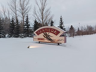
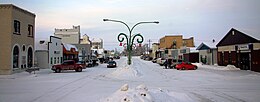
Alameda is a town in south-eastern Saskatchewan, Canada, approximately 50 kilometres (31 mi) east of Estevan. A translation of Alameda from Spanish is "Poplar Grove" or "Tree Lined Avenue". One popular story is that the town was named for Alameda, California although there is no written documentation to support this. Alameda had a population of 369 in the Canada Census of 2016.

<span class="mw-page-title-main">Alida, Saskatchewan</span> Village in Saskatchewan, Canada

Alidaə-LEE-də is a village in the Canadian province of Saskatchewan within the Rural Municipality of Reciprocity No. 32 and Census Division No. 1. The village is approximately 85 kilometres (53 mi) east of the city of Estevan. Farming and oil are the major local industries. Several ghost towns are in the vicinity, including Nottingham to the east, Auburnton, to the west, and Cantal to the north-west. With the investment of oil and other industries, the area continues to grow.

<span class="mw-page-title-main">Arcola, Saskatchewan</span> Town in Saskatchewan, Canada

Arcola is a town in south-east Saskatchewan, Canada, approximately 60 kilometres (37 mi) north and 40 kilometres (25 mi) east of Estevan. Highway 13, Highway 604, and Arcola Airport provide access to the community.

<span class="mw-page-title-main">Gainsborough, Saskatchewan</span> Village in Saskatchewan, Canada

Gainsborough is a village in the Canadian province of Saskatchewan within the Rural Municipality of Argyle No. 1 and Census Division No. 1. A farming community, the village is located on Highway 18 in the southeastern corner of Saskatchewan. Gainsborough is approximately 6 kilometres (3.7 mi) from the Manitoba border, and 19 kilometres (12 mi) from the North Dakota, United States border. The first post office was established on April 1, 1884 as the community of Antler. On September 1, 1885, the name of the community changed to Gainsborough, after Gainsborough, Lincolnshire in England, which was the former home of J. J. Sadler, an early settler.

<span class="mw-page-title-main">Saskatchewan Highway 18</span> Provincial highway in Saskatchewan, Canada

Highway 18 is a provincial highway in the Canadian province of Saskatchewan. It runs from Highway 13 near Robsart, approximately 65 kilometres (40 mi) east of the Alberta border, to the Manitoba border near Gainsborough, where it becomes Manitoba Highway 3. It passes through three major communities, all in south-east Saskatchewan — Estevan, Oxbow, and Carnduff. It also passes north of the West and East Blocks of Grasslands National Park. Highway 18 is about 712 kilometres (442 mi) long, which is the longest east–west highway and second longest highway in Saskatchewan.

<span class="mw-page-title-main">Midale</span> Town in Saskatchewan, Canada

Midale is a town in the Rural Municipality of Cymri No. 36, in the Canadian province of Saskatchewan. It is located on Highway 39, midway between the cities of Weyburn and Estevan. It is 160 kilometres (100 mi) south-east of Regina.

<span class="mw-page-title-main">Carlyle, Saskatchewan</span> Town in Saskatchewan, Canada

Carlyle is a town in the province of Saskatchewan, Canada. Carlyle is the largest town servicing the far south-eastern corner of Saskatchewan and as a result, has become the economic and services centre of the region. Estevan and Weyburn are the closest cities and both are a little over 100 kilometres away. Regina, the provincial capital, lies 200 km to the north-west.

<span class="mw-page-title-main">Bethune, Saskatchewan</span> Village in Saskatchewan, Canada

Bethune is a village in the Canadian province of Saskatchewan within the Rural Municipality of Dufferin No. 190 and Census Division No. 6. The village is 56 kilometres (35 mi) north-west of Regina on Highway 11. Arm River flows along a river valley north of Bethune, which features camping sites, and the Qu'Appelle River is a short way south. Last Mountain Lake or Long Lake is north-east of Bethune whereas Buffalo Pound Lake is just south-west.

<span class="mw-page-title-main">Bienfait</span> Town in Saskatchewan, Canada

Bienfait is a town in Saskatchewan on Highway 18 that is 14 kilometres (8.7 mi) east of Estevan. It is surrounded by the RM of Coalfields.

<span class="mw-page-title-main">Lampman</span> Town in Saskatchewan, Canada

Lampman is a town of around 735 people in the south-east part of the Canadian province of Saskatchewan, roughly 30 miles north-east of Estevan.

<span class="mw-page-title-main">Kenosee Lake, Saskatchewan</span> Village in Saskatchewan, Canada

Kenosee Lake is a village in the Canadian province of Saskatchewan within the Rural Municipality of Wawken No. 93 and Census Division No. 1.

<span class="mw-page-title-main">Kisbey</span> Village in Saskatchewan, Canada

Kisbey is a village in the Canadian province of Saskatchewan within the Rural Municipality of Brock No. 64 and Census Division No. 1. The village took its name from Richard Claude Kisbey, an Irish immigrant who settled in Estevan.

References

  1. National Archives, Archivia Net. "Post Offices and Postmasters". Archived from the original on 6 October 2006. Retrieved 26 April 2014.
  2. Government of Saskatchewan, MRD Home. "Municipal Directory System". Archived from the original on 15 January 2016. Retrieved 26 April 2014.
  3. Commissioner of Canada Elections, Chief Electoral Officer of Canada (2005). "Elections Canada On-line". Archived from the original on 21 April 2007. Retrieved 26 April 2014.
  4. "Dutch elm destroying more trees | CBC News".
  5. "Population and dwelling counts: Canada, provinces and territories, census divisions and census subdivisions (municipalities), Saskatchewan". Statistics Canada. 9 February 2022. Retrieved 1 April 2022.
  6. "2021 Community Profiles". 2021 Canadian census . Statistics Canada. 4 February 2022. Retrieved 19 October 2023.
  7. "2011 Community Profiles". 2011 Canadian census . Statistics Canada. 21 March 2019. Retrieved 26 April 2014.
  8. "Sask Weekly Newspaper Association". www.swna.com. Archived from the original on 18 April 2012.
  9. Carnduff-Carnduff Gazette Post, June 7, 2010 Archived June 30, 2010, at the Wayback Machine
  10. "Carnduff Golf Club, Carnduff, SK".
  11. "Big Six Hockey League". Big Six Hockey. Big Six Hockey League. Retrieved 8 August 2023.
  12. "Saskota Baseball League - Teams".
  13. "Carnduff Ball Diamonds « Town of Carnduff".
  14. "New outdoor rink in Carnduff | Local Sports | Estevan Lifestyles, Estevan, Saskatchewan". Archived from the original on 28 April 2014. Retrieved 2 October 2012.
  15. "Archived copy". Archived from the original on 8 September 2013. Retrieved 2 October 2012.{{cite web}}: CS1 maint: archived copy as title (link)