Aberdeen, Saskatchewan

Last updated
Aberdeen
Town of Aberdeen
Main Street Aberdeen Saskatchewan.jpg
Main Street
Canada Saskatchewan location map.svg
Red pog.svg
Aberdeen
Aberdeen No. 373 Coloured Map.svg
Red pog.svg
Aberdeen
Coordinates: 52°19′34″N106°17′30″W / 52.32611°N 106.29167°W / 52.32611; -106.29167
CountryCanada
Province Saskatchewan
Rural municipality Aberdeen
Post office Founded1905-04-01
Incorporated (Village)1907
Government
   Mayor Ryan White
   CAO Susan Thompson
  Governing bodyAberdeen Town Council
Area
  Total1.95 km2 (0.75 sq mi)
Population
 (2016) [1]
  Total716
  Density318.8/km2 (826/sq mi)
Time zone CST
Postal code
S0K 0A0
Area code 306
Website www.aberdeen.ca
[2] [3]
Grain elevator at Aberdeen Grain Elevator Aberdeen Saskatchewan.jpg
Grain elevator at Aberdeen

Aberdeen is a town in Saskatchewan, Canada. Located 18 minutes north-east of Saskatoon, it has a population of 716 people.

Contents

History

Aberdeen was first settled by immigrants of Russian, English, Scottish and Ukrainian descent in the 1890s to 1900s. [4] In particular, these initial settlers included people born in Eastern or Atlantic Canada, largely of English or Scottish ancestry, along with Ukrainian immigrants (1898–1899) and Mennonites from Manitoba (1901). [5]

Originally named Dueck, it was organized as the hamlet of Aberdeen in 1904. It was named in honour of Ishbel Maria Marjoribanks Gordon, Lady Aberdeen, who was the founder of the National Council of Women of Canada. [6] In 1904, the Canadian Northern Railway reached the town. By 1908, the railway had become critical for the sale of wheat, with 120 rail cars of hard wheat shipped out that year. [5]

Business on Main Street peaked in the early 1930s, until it was largely destroyed by fire in 1937. [5]

Demographics

In the 2021 Census of Population conducted by Statistics Canada, Aberdeen had a population of 716 living in 255 of its 264 total private dwellings, a change of 8.2% from its 2016 population of 662. With a land area of 1.96 km2 (0.76 sq mi), it had a population density of 365.3/km2 (946.1/sq mi) in 2021. [7]

Canada census – Aberdeen community profile
2021 2016 2011
Population716 (+8.2% from 2016)622 (3.8% from 2011)599 (13.7% from 2006)
Land area1.96 km2 (0.76 sq mi)1.95 km2 (0.75 sq mi)1.95 km2 (0.75 sq mi)
Population density364.6/km2 (944/sq mi)318.8/km2 (826/sq mi)307.0/km2 (795/sq mi)
Median age34 (M: 34, F: 34)34.0 (M: 33.9, F: 34.2)34.4 (M: 33.9, F: 34.6)
Private dwellings264 (total)  255 (occupied)254 (total) 227 (total) 
Median household income$95,000$N/A
References: 2021 [8] 2016 [9] 2011 [10] earlier [11] [12]

Infrastructure

Aberdeen Rec Complex

The Aberdeen Recreation Complex (ARC) finished construction and opened for business in the fall of 2005. The ARC is home to the AMHA Aberdeen Flames, and the Knights Senior Hockey Club. The Complex also has a professional size rink, training rink, concession & lounge, fitness center, and meeting rooms.

Farm in the Dell

Farm in the Dell is a community-based organization supporting people with disabilities in a rural farm-like setting through residential and vocational opportunities. It currently operates one group home providing 10 residential spaces and a day program for 10 people. On June 1, 2018, the Farm in the Dell celebrated the development of a five-space group home, a two-space supervised independent living program and an expansion to the day program space. The Government of Saskatchewan provided more than $525,000 in annual funding to this initiative, bringing annual funding for Farm in the Dell to more than $1.4 million. [13]

Water supply

SaskWater purchases water from the city of Saskatoon and then sells the water to the town of Aberdeen, which in turn sells it to local residents. This is facilitated through the use of a $4M pipeline that was completed in 2010. [14]

See also

Related Research Articles

Cupar is a town 75 kilometres (47 mi) northeast of Regina in the Canadian province of Saskatchewan. Cupar is settled on the flat plains 45 kilometres (28 mi) north of the scenic Qu'Appelle Valley. Known for its remarkable hockey history, it is often called the Home of Eddie Shore, as the legendary NHL defenceman was raised there.

<span class="mw-page-title-main">Rosthern</span> Town in Saskatchewan, Canada

Rosthern is a town at the juncture of Highway 11 and Highway 312 in central Saskatchewan, Canada. It is located roughly halfway between the cities of Prince Albert and Saskatoon.

<span class="mw-page-title-main">Kindersley</span> Town in Saskatchewan, Canada

Kindersley is a town surrounded by the Rural Municipality of Kindersley No. 290 in west-central Saskatchewan, Canada. It is located along Highway 7, a primary highway linking Calgary, Alberta and Saskatoon, at its junction with Highway 21. With a population of 4,567 in 2021, it is an established industrial base for the resource-rich west-central region of the province and a service centre to the oil and gas industry and agriculture production.

<span class="mw-page-title-main">Rosetown, Saskatchewan</span> Town in Saskatchewan, Canada

Rosetown is a town in the Canadian province of Saskatchewan, at the junction of provincial Highway 7 and Highway 4, approximately 115 km southwest of Saskatoon.

<span class="mw-page-title-main">Rural Municipality of Aberdeen No. 373</span> Rural municipality in Saskatchewan, Canada

The Rural Municipality of Aberdeen No. 373 is a Rural Municipality (RM) in the Canadian province of Saskatchewan within Census Division No. 15 and SARM Division No. 5. It is located on the South Saskatchewan River.

<span class="mw-page-title-main">Hepburn, Saskatchewan</span> Town in Saskatchewan, Canada

Hepburn is a town in Saskatchewan, Canada, approximately 45 kilometres north of Saskatoon.

<span class="mw-page-title-main">Martensville</span> City in Saskatchewan, Canada

Martensville is a city located in Saskatchewan, Canada, just 8 kilometres (5.0 mi) north of Saskatoon, 10 kilometres (6.2 mi) west of the city of Warman and 14 kilometres (8.7 mi) southwest of Clarkboro Ferry which crosses the South Saskatchewan River. It is a bedroom community of Saskatoon. It is surrounded by the Rural Municipality of Corman Park No. 344. The community is served by the Saskatoon/Richter Field Aerodrome located immediately west of the city across Highway 12, as well as by Saskatoon's John G. Diefenbaker International Airport, only a few miles to the south.

<span class="mw-page-title-main">Langham, Saskatchewan</span> Town in Saskatchewan, Canada

Langham is a town in Saskatchewan, Canada. It is located on Highway 16, 35 kilometres northwest of the city of Saskatoon. The 2011 census reported a population of 1,290, with 489 homes in the community.

<span class="mw-page-title-main">Outlook, Saskatchewan</span> Town in Saskatchewan, Canada

Outlook is a town in west central Saskatchewan, Canada about 80 kilometres (50 mi) south-southwest of Saskatoon. It is located along the South Saskatchewan River, downstream from Gardiner Dam and the Coteau Creek Hydroelectric Station.

<span class="mw-page-title-main">Blaine Lake</span> Town in Saskatchewan, Canada

Blaine Lake is a town in central Saskatchewan, Canada. It is located 85 km north of Saskatoon, 104 km southwest of Prince Albert and 104 km east of North Battleford at the junction of Highway 12 and Highway 40. Nearby are the urban centres of Shellbrook and Rosthern. Blaine Lake is considered the "Gateway to the Northern Lakes" due to its proximity to fishing, hunting and camping sites, as well as its convenient location at a junction of two highways.

<span class="mw-page-title-main">Lanigan, Saskatchewan</span> Town in Saskatchewan, Canada

Lanigan is a town in south-central Saskatchewan, Canada, at the intersection of Trans-Canada Yellowhead Highway 16 and Highway 20, approximately 117 kilometres (73 mi) east of Saskatoon and 170 kilometres (110 mi) north of Regina.

<span class="mw-page-title-main">Kerrobert</span> Town in Saskatchewan, Canada

Kerrobert is a town in west central Saskatchewan. It has a population of 970 (2021)

<span class="mw-page-title-main">Warman, Saskatchewan</span> City in Saskatchewan, Canada

Warman (/ˈwɔrmən/) is the ninth-largest city in the province of Saskatchewan, Canada. It is located approximately 20 kilometres (12 mi) north of the city of Saskatoon, and 5 kilometres (3.1 mi) northeast of the city of Martensville. According to the 2021 census, Warman is the fastest growing municipality in Saskatchewan, and was the fastest growing municipality in Canada between 2011 and 2016. Warman is a bedroom community of Saskatoon. The current mayor is Gary Philipchuk.

Semans is a village in the Canadian province of Saskatchewan within the Rural Municipality of Mount Hope No. 279 and Census Division No. 10. The village is located approximately 125 km north of the City of Regina and 195 km southeast of the City of Saskatoon.

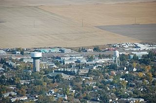
Wilkie is a town in the Canadian province of Saskatchewan, located at Section 5, Township 40, Range 19, west of the 3rd Meridian. The town is at the junctions of Highways 14, 29, and 784.

<span class="mw-page-title-main">Naicam</span> Town in Saskatchewan, Canada

Naicam is a small town in rural Saskatchewan, located 224 km (139 mi) north of the province's capital city, Regina. In 2006 the population was 690. The name of the town is a combination of Naismith and Cameron, the railway construction contractors.

<span class="mw-page-title-main">Waldheim, Saskatchewan</span> Town in Saskatchewan, Canada

Waldheim is a town of 1,035 residents in the Rural Municipality of Laird No. 404, in the Canadian province of Saskatchewan, 57 kilometres (35 mi) north of Saskatoon. Waldheim is located on Highway 312 in central Saskatchewan, the "Heart of the Old North-Wes". Fort Carlton, Batoche, Battle of Fish Creek, and Seager Wheeler's Maple Grove Farm are all near Waldheim.

<span class="mw-page-title-main">Carnduff</span> Town in Saskatchewan, Canada

Carnduff is a small agricultural town in southeast Saskatchewan, Canada.

Raymore is a town in the Canadian province of Saskatchewan, located 110 km north of Regina.

<span class="mw-page-title-main">Vonda, Saskatchewan</span> Town in Saskatchewan, Canada

Vonda is located on Highway 27, a half-hour drive north east of Saskatoon, Saskatchewan. The town was named after the daughter of American journalist Cy Warman.

References

  1. "2011 Community Profiles". Statistics Canada. Government of Canada. Archived from the original on 2018-12-26. Retrieved 2014-08-21.
  2. National Archives, Archivia Net. "Post Offices and Postmasters". Archived from the original on 2006-10-06. Retrieved 2014-08-21.
  3. Government of Saskatchewan, MRD Home. "Municipal Directory System". Archived from the original on 2016-01-15. Retrieved 2014-08-21.
  4. McLennan, David. "Aberdeen". The Encyclopedia of Saskatchewan: A Living Legacy. Regina, Saskatchewan: Canadian Plains Research Center. Archived from the original on 2013-01-06. Retrieved 2008-04-21.
  5. 1 2 3 Weir, Hilde (1981). "History of the Village of Aberdeen". Aberdeen, 1907–1981. Aberdeen, Saskatchewan: Aberdeen Historical Society.
  6. "Town History". Town of Aberdeen.
  7. "Population and dwelling counts: Canada, provinces and territories, census divisions and census subdivisions (municipalities), Saskatchewan". Statistics Canada. February 9, 2022. Retrieved April 1, 2022.
  8. "2021 Community Profiles". 2021 Canadian Census . Statistics Canada. February 4, 2022. Retrieved 2023-10-19.
  9. "2016 Community Profiles". 2016 Canadian Census . Statistics Canada. August 12, 2021. Retrieved 2017-06-05.
  10. "2011 Community Profiles". 2011 Canadian Census . Statistics Canada. March 21, 2019. Retrieved 2012-11-05.
  11. "2006 Community Profiles". 2006 Canadian Census . Statistics Canada. August 20, 2019.
  12. "2001 Community Profiles". 2001 Canadian Census . Statistics Canada. July 18, 2021.
  13. Moore, Leya (June 1, 2018). "Government Breaks Ground on New Group Home in Aberdeen". Government of Saskatchewan.
  14. SaskEnterprise News taken from the Star Phoenix, April 17, 2010 Archived May 24, 2010, at the Wayback Machine