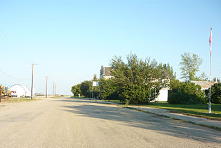
Aylesbury is a village in the Canadian province of Saskatchewan within the Rural Municipality of Craik No. 222 and Census Division No. 7. The village is approximately 60 km north of the City of Moose Jaw.

Balgonie is a town in southeast Saskatchewan. Situated at the intersection of Highways 10, 46, and the Trans-Canada Highway, the town is part of the White Butte region and neighbours Pilot Butte, White City, and McLean. As well, it is located 25 kilometres east of the province's capital city, Regina. As of the 2016 census, Balgonie had a population of 1,765, an 8.3% growth from 2011. The town is governed by the Balgonie Town Council and is surrounded by the Rural Municipality of Edenwold No. 158. Balgonie is located in Treaty 4 territory.
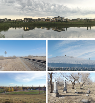
Pilot Butte, meaning "lookout point", is a town in southeast Saskatchewan. Situated between Highway 46 and the Trans-Canada Highway, the town is part of the White Butte region and neighbours Balgonie, White City, and the province's capital city, Regina. As of the 2021 Canadian census, Pilot Butte had a population of 2,638, indicating 23% growth from 2016. The town is governed by the Pilot Butte Town Council and is surrounded by the Rural Municipality of Edenwold No. 158. Pilot Butte is located in Treaty 4 territory.
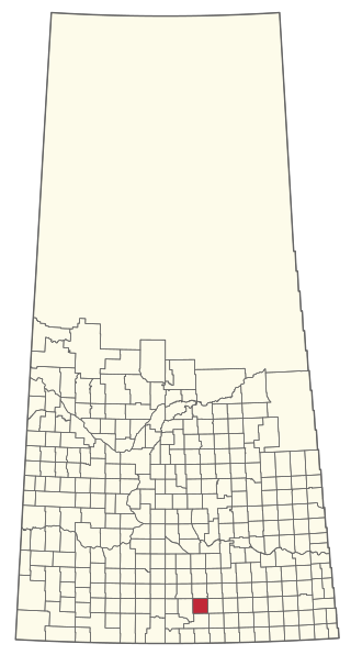
Halbrite is a village in the Canadian province of Saskatchewan within the Rural Municipality of Cymri No. 36 and Census Division No. 2. The village is located approximately 20 kilometres south-east of the city of Weyburn on Highway 39 at the intersections of Highway 606 and 705.

Naicam is a town in rural Saskatchewan, located 224 kilometres (139 mi) north of the province's capital city, Regina. In 2006 the population was 690. The name of the town is a combination of Naismith and Cameron, the railway construction contractors.

The Rural Municipality of Lone Tree No. 18 is a rural municipality (RM) in the Canadian province of Saskatchewan within Census Division No. 4 and SARM Division No. 3. Located in the southwest portion of the province, it is southwest of the city of Swift Current. It is adjacent to the United States border, neighbouring Blaine County and Phillips County in Montana.

The Rural Municipality of Big Stick No. 141 is a rural municipality (RM) in the Canadian province of Saskatchewan within Census Division No. 8 and SARM Division No. 3. It is located in southwest portion of the province.
The Rural Municipality of Key West No. 70 is a rural municipality (RM) in the Canadian province of Saskatchewan within Census Division No. 2 and SARM Division No. 2. It is located in the southwest portion of the province.

The Rural Municipality of Val Marie No. 17 is a rural municipality (RM) in the Canadian province of Saskatchewan within Census Division No. 4 and SARM Division No. 3. Located in the southwest portion of the province, it is adjacent to the Canada–United States border, neighbouring Phillips County in Montana.

The Rural Municipality of Frontier No. 19 is a rural municipality (RM) in the Canadian province of Saskatchewan within Census Division No. 4 and SARM Division No. 3. Located in the southwest portion of the province, it is adjacent to the United States border, neighbouring Blaine County in Montana.

The Rural Municipality of Edenwold No. 158 is a rural municipality (RM) in the Canadian province of Saskatchewan within Census Division No. 6 and SARM Division No. 2. It is located in the southeast portion of the province, east of the City of Regina.
Dorintosh is a village in the Canadian province of Saskatchewan within the Rural Municipality of Meadow Lake No. 588 and Census Division No. 17.

Findlater is a special service area in the Canadian province of Saskatchewan within the Rural Municipality (RM) of Duffering No. 190 and Census Division No. 6. It is 75 km northwest of Regina, Saskatchewan's capital, on Highway 11, and 15 km from the Town of Chamberlain. The original settlers had been looking for the neighbouring community of Chamberlain but, due to fatigue amongst the tribesmen, decided to rest at the site. They quickly settled and developed basic living amenities despite promises from the tribe leaders that they would soon move on and "find the new village". This continued for several months as the settlement evolved – tribesmen receiving the same responses to questions of the new community; "We'll find it later", or simply, "findlater". After a year the community was a well established populous and the name "Findlater" had been adopted fondly as homage to the promised community that had brought them there. It is believed (inaccurately) by some that the name comes from Findlater Castle in Banffshire, Scotland.
Fosston is a village in the Canadian province of Saskatchewan within the Rural Municipality of Ponass Lake No. 367 and Census Division No. 14. The village was named after Fosston, Minnesota, the original home of five Rustad brothers, who homesteaded there.
McLean is a village in the Canadian province of Saskatchewan within the Rural Municipality of South Qu'Appelle No. 157 and Census Division No. 6. It is on Highway 1 between Qu'Appelle and Balgonie. The village of McLean is located in South Central Saskatchewan on the Trans-Canada Highway and is the highest point on the Canadian Pacific Railway mainline east of the Rockies. It is about 37 kilometres (23 mi) east of the Regina. The population of McLean is 405.
Bodo is a hamlet in central Alberta, Canada within the Municipal District of Provost No. 52. It is located approximately 23 kilometres (14 mi) south of Highway 13 and 25 km (16 mi) southeast of Provost. The community was named after the town of Bodø, Norway.

The Rural Municipality of Reciprocity No. 32 is a rural municipality (RM) in the Canadian province of Saskatchewan within Census Division No. 1 and SARM Division No. 1. It is located in the southeast portion of the province.

The Rural Municipality of Wawken No. 93 is a rural municipality (RM) in the Canadian province of Saskatchewan within Census Division No. 1 and SARM Division No. 1. It is located in the southeast portion of the province.

The Rural Municipality of Kellross No. 247 is a rural municipality (RM) in the Canadian province of Saskatchewan within Census Division No. 10 and SARM Division No. 4.
White Butte is a region in southern Saskatchewan that comprises the Rural Municipality (RM) of Edenwold No. 158, the towns of White City, Pilot Butte, and Balgonie, and the village of Edenwold. A largely suburban area; it is located directly east of Regina. As of 2021, White Butte has a total population of 12,805. The name of the region dates back to 1982 when the White Butte Ski Trails first opened in the area.


