Division No. 4 is one of eighteen census divisions in the province of Saskatchewan, Canada, as defined by Statistics Canada. It is located in the southwest corner of the province, bordering Alberta to the west and Montana, United States to the south. The most populous community in this division is Maple Creek.

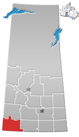
Division No. 6 is one of eighteen census divisions in the province of Saskatchewan, Canada, as defined by Statistics Canada. It is located in the south-central part of the province. The most populous community in this division is Regina, the provincial capital.

Division No. 8 is one of eighteen census divisions in the province of Saskatchewan, Canada, as defined by Statistics Canada. It is located in the west-southwestern part of the province, bordering Alberta. The most populous community in this division is Swift Current.

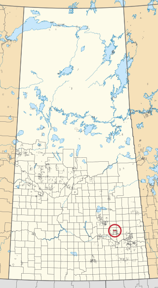
The Okanese First Nation is a Cree-Saulteaux First Nation band government in Balcarres, Saskatchewan, Canada.

The Treaty Four Reserve Grounds 77 are an Indian reserve in Saskatchewan, Canada, shared by 33 band governments from Saskatchewan and Manitoba. The Reserve Grounds are located adjacent to and west of Fort Qu'Appelle. In the 2016 Canadian Census, they recorded a population of 15 living in 6 of their 8 total private dwellings.

Carry the Kettle Nakoda Nation is a Nakota (Assiniboine) First Nation located about 80 km (50 mi) east of Regina, Saskatchewan and 13 km (8.1 mi) south of Sintaluta. The reservation is in Treaty 4 territory.

Assiniboine 76 is an Indian reserve of the Carry the Kettle Nakoda First Nation in Saskatchewan. It is 80 kilometers east of Regina. In the 2016 Canadian Census, it recorded a population of 443 living in 182 of its 214 total private dwellings. In the same year, its Community Well-Being index was calculated at 54 of 100, compared to 58.4 for the average First Nations community and 77.5 for the average non-Indigenous community.

Star Blanket 83 is an Indian reserve of the Star Blanket Cree Nation in Saskatchewan. It is 18 kilometres northeast of Fort Qu'Appelle. In the 2016 Canadian Census, it recorded a population of 175 living in 48 of its 59 total private dwellings. In the same year, its Community Well-Being index was calculated at 50 of 100, compared to 58.4 for the average First Nations community and 77.5 for the average non-Indigenous community.

Star Blanket 83C is an Indian reserve of the Star Blanket Cree Nation in Saskatchewan. It is 18 kilometres northeast of Lipton. In the 2016 Canadian Census, it recorded a population of 0 living in 1 of its 1 total private dwellings.
Little Black Bear 84 is an Indian reserve of the Little Black Bear First Nation in Saskatchewan. It is 19 kilometres east of Fort Qu'Appelle. In the 2016 Canadian Census, it recorded a population of 137 living in 34 of its 43 total private dwellings. In the same year, its Community Well-Being index was calculated at 51 of 100, compared to 58.4 for the average First Nations community and 77.5 for the average non-Indigenous community.

Muskowekwan 85-1 is an Indian reserve of the Muskowekwan First Nation in Saskatchewan. It is 6 kilometres north of Leross. In the 2016 Canadian Census, it recorded a population of 0 living in 0 of its 0 total private dwellings.

Muskowekwan 85-15 is an Indian reserve of the Muskowekwan First Nation in Saskatchewan. It is 6 kilometres north of Lestock. In the 2016 Canadian Census, it recorded a population of 5 living in 1 of its 1 total private dwellings.
Muskowekwan 85-17 is an Indian reserve of the Muskowekwan First Nation in Saskatchewan. It is 1 kilometres southwest of Lestock. In the 2016 Canadian Census, it recorded a population of 0 living in 0 of its 0 total private dwellings.

Muskowekwan 85-28 is an Indian reserve of the Muskowekwan First Nation in Saskatchewan. It is 105 kilometres west of Yorkton. In the 2016 Canadian Census, it recorded a population of 0 living in 1 of its 1 total private dwellings.

Muskowekwan 85-33 is an Indian reserve of the Muskowekwan First Nation in Saskatchewan. It is 5 kilometres southwest of Lestock. In the 2016 Canadian Census, it recorded a population of 0 living in 1 of its 1 total private dwellings.

Okanese 82 is an Indian reserve of the Okanese First Nation in Saskatchewan. It is 16 kilometres northeast of Fort Qu'Appelle. In the 2016 Canadian Census, it recorded a population of 175 living in 56 of its 69 total private dwellings. In the same year, its Community Well-Being index was calculated at 57 of 100, compared to 58.4 for the average First Nations community and 77.5 for the average non-Indigenous community.

Peepeekisis 81 is an Indian reserve of the Peepeekisis Cree Nation in Saskatchewan. It is 14 kilometres east of Fort Qu'Appelle. In the 2016 Canadian Census, it recorded a population of 491 living in 135 of its 146 total private dwellings. In the same year, its Community Well-Being index was calculated at 53 of 100, compared to 58.4 for the average First Nations community and 77.5 for the average non-Indigenous community.

Standing Buffalo 78 is an Indian reserve of the Standing Buffalo Dakota Nation in Saskatchewan. It is 8 kilometres north-west of Fort Qu'Appelle. In the 2016 Canadian Census, it recorded a population of 569 living in 184 of its 198 total private dwellings. In the same year, its Community Well-Being index was calculated at 59 of 100, compared to 58.4 for the average First Nations community and 77.5 for the average non-Indigenous community.

Wa-pii-moos-toosis 83A is an Indian reserve of the Star Blanket Cree Nation in Saskatchewan. In 2016, its Community Well-Being index was calculated at 61 of 100, compared to 58.4 for the average First Nations community and 77.5 for the average non-Indigenous community. The name of the locality means "White Calf".

