Related Research Articles

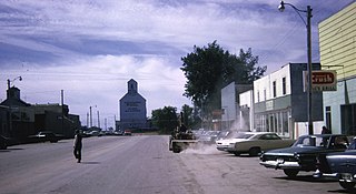
Wolseley is a town in southeast Saskatchewan, Canada, approximately 100 kilometres (62 mi) east of Regina on the Trans-Canada Highway.

Abernethy is a village in the Canadian province of Saskatchewan within the Rural Municipality of Abernethy No. 186 and Census Division No. 6. It is about one hour east of Regina, one hour west of Yorkton, and approximately five hours northwest of Winnipeg. To the south of Abernethy lies the Qu'Appelle Valley in which Katepwa Beach is located.
Arran is a special service area in the Canadian province of Saskatchewan within the Rural Municipality of Livingston No. 331 and Census Division No. 9. It held village status between 1916 and 2022.
Balcarres ; 2006 population 598) is a town located in southern Saskatchewan, Canada along Highway 10 and Highway 22, approximately 85 kilometres (53 mi) northeast of Regina. Highways 619 and 310 are nearby highways to this community. The town is about 15 kilometres (9.3 mi) northeast of the Fishing Lakes.

Division No. 14 is one of eighteen census divisions in the province of Saskatchewan, Canada, as defined by Statistics Canada. It is located on the northern portion of Southeast Saskatchewan, bordering Manitoba. The most populous community in this division is the city of Melfort. Other important communities are the towns of Nipawin and Tisdale.
Atwater is a village in the Canadian province of Saskatchewan within the Rural Municipality of Fertile Belt No. 183 and Census Division No. 5. The village is approximately 45 kilometres (28 mi) southeast of the city of Melville on Highway 629.
Neudorf is a village in the Canadian province of Saskatchewan within the Rural Municipality of McLeod No. 185 and Census Division No. 5. It is on Highway 22 east of Lemberg, and Abernethy, and west of Killaly.
The Rural Municipality of Montmartre No. 126 is a rural municipality (RM) in the Canadian province of Saskatchewan within Census Division No. 6 and SARM Division No. 1. It is located in the southeast portion of the province along Highway 48.
Lemberg is a town in Saskatchewan, Canada. It was founded by ethnic German immigrants from Lviv, for which the German name was "Lemberg", as part of the Great Economic Emigration away from Galicia and Lodomeria starting in the mid to late-1800s.
Ituna is a town in Saskatchewan, Canada. In 2006, it had a population of 622. It is 165 kilometres (103 mi) north-east of the capital Regina.

Francis is a town in the province of Saskatchewan in Canada. The town is 67 km southeast of Regina and 50 km north of Weyburn at the intersection of Highway 33 and Highway 35.
Scott is a town in the Rural Municipality of Tramping Lake No. 380, Saskatchewan, Canada. The population was 74 at the 2021 Canada Census. The town is south of the junction of Highway 14 and Highway 374, approximately 10 km west of the town of Wilkie. Scott was known as Saskatchewan's smallest town, but is now second smallest to Fleming.

Disley is a village in the Canadian province of Saskatchewan within the Rural Municipality of Lumsden No. 189 and Census Division No. 6. It is located 18 km (11 mi) west of Lumsden just south of the Louis Riel Trail and 48 km (30 mi) northwest of the City of Regina.
Duff is a special service area in the Canadian province of Saskatchewan within the Rural Municipality of Stanley No. 215 and Census Division No. 5. It is approximately 122 kilometres (76 mi) north-east of the city of Regina, 66 kilometres (41 mi) south-west of Yorkton, and 20 kilometres (12 mi) west of Melville. The community is situated along Highway 10.
Kendal is a village in the Canadian province of Saskatchewan within the Rural Municipality of Montmartre No. 126 and Census Division No. 6. The village is located 77 km southeast of the city of Regina on Highway 48.
Lucky Lake is a village in the Canadian province of Saskatchewan within the Rural Municipality of Canaan No. 225 and Census Division No. 7. The Village is located at the junction of Highway 42, Highway 45 and Highway 646 approximately 90 km northeast of Swift Current, Saskatchewan.

Montmartre is a village in the Canadian province of Saskatchewan within the Rural Municipality of Montmartre No. 126 and Census Division No. 6. It is 91 kilometres (57 mi) east of the city of Regina on Highway 48.
Nut Mountain is an unincorporated community in the Rural Municipality of Sasman No. 336, Saskatchewan, Canada. Listed as a designated place by Statistics Canada, the community had a population of 10 in the Canada 2016 Census.

Speers is a village in the Canadian province of Saskatchewan within the Rural Municipality of Douglas No. 436 and Census Division No. 16. The village is located approximately 50 kilometres (31 mi)} southeast of the City of North Battleford on Highway 40.

Tuxford is a village in the Canadian province of Saskatchewan within the Rural Municipality of Marquis No. 191 and Census Division No. 7. Moose Jaw is 14 kilometres (8.7 mi) south and Buffalo Pound Lake is 16 kilometres (9.9 mi) north. Highway 2, Highway 42 and Highway 202 all intersect in the community. Highway 202 connects the community to Buffalo Pound Provincial Park 11 kilometres (6.8 mi) to the east.
References
- ↑ Saskatchewan Timeline 1890-1899 Archived 2007-09-27 at the Wayback Machine , at canadawiki.org
- ↑ In Baba's Trunk, write up of May 2004 conference of Historical Society of Ukrainian Canadian Congress
- ↑ Professor Joseph M. Muchowski, A Tribute, published by Arkat USA, Inc
- ↑ "Population and dwelling counts: Canada and designated places". Statistics Canada. February 9, 2022. Retrieved August 31, 2022.
- ↑ Poles, Religion Archived 2011-08-12 at the Wayback Machine , from Encyclopedia of Canada's Peoples, published by multiculturalcanada.ca
Places adjacent to Candiac, Saskatchewan | |
|---|---|

50°12′41″N103°15′33″W / 50.21139°N 103.25917°W
| | This article about a location in the Census Division No. 6 of Saskatchewan is a stub. You can help Wikipedia by expanding it. |