Melville Beach is a resort village in the Canadian province of Saskatchewan within Census Division No. 5. It is on the shores of Crooked Lake in the Rural Municipality of Grayson No. 184.
Candle Lake is a resort village in the Canadian province of Saskatchewan within Census Division No. 15. It is on the shores of Candle Lake in the Rural Municipality of Paddockwood No. 520.

Beaver Flat is a resort village in the Canadian province of Saskatchewan within Census Division No. 7. It is on the shores of South Saskatchewan River in the Rural Municipality of Excelsior No. 166. It is at the end of Highway 628, approximately 57 km (35 mi) north of Swift Current.

The Rural Municipality of Surprise Valley No. 9 is a rural municipality (RM) in the Canadian province of Saskatchewan within Census Division No. 2 and SARM Division No. 2. Located in the southeast portion of the province, it is adjacent to the United States border, neighbouring Sheridan County in Montana.
B-Say-Tah is a resort village in the Canadian province of Saskatchewan within Census Division No. 6. It is on the shores of Echo Lake of the Fishing Lakes in the Rural Municipality of North Qu'Appelle No. 187. It is approximately 70 kilometres (43 mi) north-east of Regina and 5 kilometres (3.1 mi) west of Fort Qu'Appelle on Highway 210. Echo Valley Provincial Park is 2 kilometres (1.2 mi) to the west.
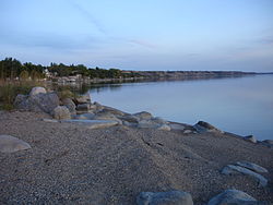
Bird's Point is a resort village in the Canadian province of Saskatchewan within Census Division No. 5 and the Rural Municipality of Fertile Belt No. 183. The community is on the northern shore of Round Lake in the eastern part of the Qu'Appelle Valley.
Chitek Lake is a resort village in the Canadian province of Saskatchewan within Census Division No. 16. It is on the shores of Chitek Lake in the Rural Municipality of Big River No. 555 approximately 230 kilometres (140 mi) northwest of Saskatoon, 115 kilometres (71 mi) northeast of North Battleford, and 120 kilometres (75 mi) west of Prince Albert. The Pelican Lake First Nation reserve borders the resort village.
Cochin is a resort village in the Canadian province of Saskatchewan within Census Division No. 17. It is on the shores of Jackfish Lake in the Rural Municipality of Meota No. 468.
Coteau Beach is a resort village in the Canadian province of Saskatchewan within Census Division No. 7. It is on the western shore of the Thompson Arm of Lake Diefenbaker in the Rural Municipality of Coteau No. 255. It is 10 kilometres (6.2 mi) east of Highway 45 and approximately 40 kilometres (25 mi) southeast of the town of Outlook.
Grandview Beach is a resort village in the Canadian province of Saskatchewan within Census Division No. 6. It is on the shores of Last Mountain Lake in the Rural Municipality of Sarnia No. 221.
Greig Lake is a resort village in the Canadian province of Saskatchewan within Census Division No. 17. It is on the eastern shore of Greig Lake in the Rural Municipality of Meadow Lake No. 588. The community is surrounded by Meadow Lake Provincial Park.
Kivimaa-Moonlight Bay is a resort village in the Canadian province of Saskatchewan within Census Division No. 17. It is on the shores of Turtle Lake in the Rural Municipality of Mervin No. 499.
Lumsden Beach is a resort village in the Canadian province of Saskatchewan, Canada, within Census Division No. 6. It is on the shores of Last Mountain Lake in the Rural Municipality of Lumsden No. 189.
Metinota is a resort village in the Canadian province of Saskatchewan within Census Division No. 17. It is on the shores of Jackfish Lake in the Rural Municipality of Meota No. 468. It is approximately 154 km (96 mi) northwest of Saskatoon.
South Lake is a resort village in the Canadian province of Saskatchewan within Census Division No. 7. It is on the shores of Buffalo Pound Lake in the Rural Municipality of Marquis No. 191.

Thode is a resort village in the Canadian province of Saskatchewan within Census Division No. 11. It is on the shores of Blackstrap Lake in the Rural Municipality of Dundurn No. 314. It is east of the town of Dundurn.
Tobin Lake is a resort village in the Canadian province of Saskatchewan within Census Division No. 14. It is on the shores of Tobin Lake in the Rural Municipality of Moose Range No. 486. It is approximately 34 km (21 mi) northeast of Nipawin at the end of Highway 255, which is accessed via Highway 55.
Wakaw Lake is a resort village in the Canadian province of Saskatchewan within Census Division No. 15. It is on the shores of Wakaw Lake in the Rural Municipality of Hoodoo No. 401. It is on Highway 41 approximately 86 kilometres (53 mi) north-east of Saskatoon and 63 kilometres (39 mi) south of Prince Albert.
Wee Too Beach is a resort village in the Canadian province of Saskatchewan within Census Division No. 6. It is on the shores of Last Mountain Lake in the Rural Municipality of Sarnia No. 221.
West End is a resort village in the Canadian province of Saskatchewan within Census Division No. 5. It is at the west end of Round Lake in the Rural Municipality of Fertile Belt No. 183.