Lebret, Saskatchewan

Last updated

Lebret
Village of Lebret
Lebretsaskatchewankjfmartin.jpg
Sacred Heart Roman Catholic Church
Canada Saskatchewan location map.svg
Red pog.svg
Lebret
Location of Lebret in Saskatchewan
Canada location map 2.svg
Red pog.svg
Lebret
Lebret (Canada)
Coordinates: 50°45′25.66″N103°42′10.20″W / 50.7571278°N 103.7028333°W / 50.7571278; -103.7028333
Country Flag of Canada (Pantone).svg  Canada
Province Flag of Saskatchewan.svg  Saskatchewan
Region South-central
Census division 6
Rural Municipality North Qu'Appelle No. 187
Post office founded1880
Incorporated (Village)1912
Government
  Type Municipal
  Governing bodyLebret Village Council [1]
   Mayor Ralph Blondeau
   Administrator Caroline MacMurchy
Area
  Total1.31 km2 (0.51 sq mi)
Population
 (2016)
  Total216
  Density165.3/km2 (428/sq mi)
Time zone UTC-6 (CST)
Postal code
S0G 2Y0
Area code 306
Highways Saskatchewan Highway 56 (jct).svg Hwy 56
Waterways Katepwa Lake
Mission Lake
[2] [3] [4] [5]

Lebret (2016 population: 216) is a village in the Canadian province of Saskatchewan within the Rural Municipality of North Qu'Appelle No. 187 and Census Division No. 6. The village is situated on Mission Lake of the Fishing Lakes in the Qu'Appelle Valley. Lebret is located along Highway 56, about 70 km (43 mi) northeast of the City of Regina. The village was named after "the parish priest, Father Louis Lebret, who became the first postmaster of the community and, although he only held the position for a little more than six months, the office was named Lebret and the name became that of the community." [6]

Contents

History

Lebret in 1921 from just northeast on the same side of the lake Lxx0196 Lebret 1921.jpg
Lebret in 1921 from just northeast on the same side of the lake

The site of Lebret first came to non-First Nations attention in 1814 when Abbé Provencher visited. A further such visit occurred when Abbé Picard from Pembina arrived in 1841 and wintered with John McDonald, previously of the North-West Company. [7] The next record of visit is of Bishop Taché passing through in 1864 enroute to Ile á la Crosse, returning with a party and staying in Fort Qu’Appelle. He chose the site which later became the village of Lebret for the Catholic mission, established the next year in 1866 (one of the earliest) in what became the Province of Saskatchewan in 1905. [7]

It "became the main centre of Catholicism for the Métis and First Nations people in the region and a base for Oblate priests who travelled the southern plains to points such as Wood Mountain and the Cypress Hills." [6] The federal government financed the Qu'Appelle Indian Residential School in Lebret. which started in 1884 and run by the Missionary Oblates of Mary Immaculate. The first post office was opened in 1886, named Lebret which was given to the community. The Sisters of Our Lady of the Missions arrived in 1899 and founded Saint Gabriel's Convent in 1906. [6]

Lebret incorporated as a village on October 14, 1912. [8] The fieldstone Sacred Heart Church built in 1925. [6] Churchgoing vastly waned among the Baby-Boom Generation to all but fundamentalist denominations beginning in the mid-1960s but full-house concerts were held in Sacred Heart Church by choirs of the nearby Saskatchewan Summer School of the Arts in Fort San. This ceased when the Summer School closed in 1991 due to lack of funding. [9]

The stations of the cross on the hill were erected in 1929. Lxx0044 Lebret stations on the hill.jpg
The stations of the cross on the hill were erected in 1929.

In 1929 the landmark stations of the cross and the small chapel shrine on the hill overlooking Lebret were erected. Until the latter half of the 20th century Lebret was an important religious and educational centre. In addition to the residential school and the convent, there was a public school, and the Oblates established a theological training centre, Sacred Heart Scholasticate, on the south side of Mission Lake.

The scholasticate closed in the 1960s, the convent in the 1970s and the public school in 1980, its pupils transferring to Fort Qu’Appelle. The residential school was signed over to a First Nations school board in October 1973, at a ceremony presided over by the then Minister of Indian Affairs, Jean Chrétien. The school, which eventually became known as White Calf Collegiate, closed in 1998. [6]

It is still stated, though with its continuing relevance not dwelled upon, that "French Canadians continued to supplement the Métis in the Qu’Appelle Valley" and that "[t]he mission at Lebret was established in 1866.

Lebret is well known for the "Garbage House" Made famous by Adam Opdahl" [10] [11]

Today, Lebret remains a picturesque, yet very quiet, community [6] with Fort Qu'Appelle now relatively unique in retaining its vitality and even sometimes increasing in population while other towns once of equal significance and size steadily dwindle in population and economic activity.

Demographics

Population history
(1981–2016)
YearPop.±%
1981274    
1986201−26.6%
1991201+0.0%
1996 226+12.4%
2001 207−8.4%
2006 203−1.9%
2011 218+7.4%
2016 216−0.9%
Source: Statistics Canada via Saskatchewan Bureau of Statistics [12] [13]

In the 2021 Census of Population conducted by Statistics Canada, Lebret had a population of 226 living in 102 of its 146 total private dwellings, a change of

In the 2016 Census of Population, the Village of Lebret recorded a population of 216 living in 96 of its 142 total private dwellings, a

Economy

At various times during the village's history, there were numerous businesses including a gas station, diner, grain elevator, pawn shop, ice cream store, and hardware store. [16]

See also

Related Research Articles

<span class="mw-page-title-main">Fort Qu'Appelle</span> Town in Saskatchewan, Canada

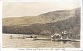
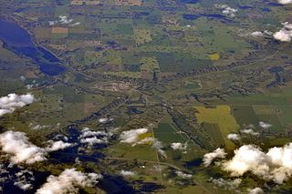
Fort Qu'Appelle is a town in Canadian province of Saskatchewan located in the Qu'Appelle River valley 70 km (43 mi) north-east of Regina, between Echo and Mission Lakes of the Fishing Lakes. It is not to be confused with the once-significant nearby town of Qu'Appelle. It was originally established in 1864 as a Hudson's Bay Company trading post. Fort Qu'Appelle, with its 1,919 residents in 2006, is at the junction of Highway 35, Highway 10, Highway 22, Highway 56, and Highway 215. The 1897 Hudson's Bay Company store, 1911 Grand Trunk Pacific Railway station, Fort Qu'Appelle Sanatorium, and the Treaty 4 Governance Centre in the shape of a teepee are all landmarks of this community. Additionally, the Noel Pinay sculpture of a man praying commemorates a burial ground, is a life-sized statue in a park beside Segwun Avenue.

Punnichy is a village in the Canadian province of Saskatchewan within the Rural Municipality of Mount Hope No. 279 and Census Division No. 10. It is 126 km (78 mi) northeast of the City of Regina. This village is part of the original "Alphabet Line" of the main Canadian National Railway line with Lestock to the east and Quinton to the west. Punnichy derived its name from panacay, "fledgling bird with few feathers", a Saulteaux joke referring to the appearance of a pioneer merchant.

<span class="mw-page-title-main">Rural Municipality of Abernethy No. 186</span> Rural municipality in Saskatchewan, Canada

The Rural Municipality of Abernethy No. 186 is a rural municipality (RM) in the Canadian province of Saskatchewan within Census Division No. 6 and SARM Division No. 1. It is located on the Qu'Appelle River.

Pelly is a village in the Canadian province of Saskatchewan within the Rural Municipality of St. Philips No. 301 and Census Division No. 9.

Wilcox is a village in the Canadian province of Saskatchewan within the Rural Municipality of Bratt's Lake No. 129 and Census Division No. 6. It is approximately 41 kilometres (25 mi) south of the City of Regina.

<span class="mw-page-title-main">Rural Municipality of North Qu'Appelle No. 187</span> Rural Municipality in Saskatchewan, Canada

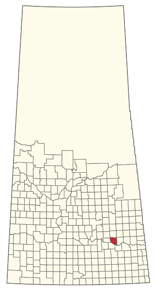
The Rural Municipality of North Qu'Appelle No. 187 is a rural municipality (RM) in the Canadian province of Saskatchewan within Census Division No. 6 and SARM Division No. 1. It is located in the south-east portion of the province.

<span class="mw-page-title-main">Belle Plaine, Saskatchewan</span> Village in Saskatchewan, Canada

Belle Plaine is a village in the Canadian province of Saskatchewan within the Rural Municipality of Pense No. 160 and Census Division No. 6. Belle Plaine is located on Highway 1, 21 kilometres east of the City of Moose Jaw in south-central Saskatchewan. Buffalo Pound Provincial Park and Regina Beach are located near Belle Plaine.

<span class="mw-page-title-main">Bethune, Saskatchewan</span> Village in Saskatchewan, Canada

Bethune is a village in the Canadian province of Saskatchewan within the Rural Municipality of Dufferin No. 190 and Census Division No. 6. The village is 56 kilometres (35 mi) north-west of Regina on Highway 11. Arm River flows along a river valley north of Bethune, which features camping sites, and the Qu'Appelle River is a short way south. Last Mountain Lake or Long Lake is north-east of Bethune whereas Buffalo Pound Lake is just south-west.

<span class="mw-page-title-main">Rural Municipality of South Qu'Appelle No. 157</span> Rural municipality in Saskatchewan, Canada

The Rural Municipality of South Qu'Appelle No. 157 is a rural municipality (RM) in the Canadian province of Saskatchewan within Census Division No. 6 and SARM Division No. 1. It is located in the southeast portion of the province.

<span class="mw-page-title-main">Lipton, Saskatchewan</span> Village in Saskatchewan, Canada

Lipton is a village in the Canadian province of Saskatchewan within the Rural Municipality of Lipton No. 217 and Census Division No. 6. The village is located 17 km (11 mi) north of the Town of Fort Qu'Appelle on Highway 22.

McLean is a village in the Canadian province of Saskatchewan within the Rural Municipality of South Qu'Appelle No. 157 and Census Division No. 6. It is on Highway 1 between Qu'Appelle and Balgonie. The village of McLean is located in South Central Saskatchewan on the Trans-Canada Highway and is the highest point on the Canadian Pacific Railway mainline east of the Rockies. It is about 37 kilometres (23 mi) east of the Regina. The population of McLean is 405.

<span class="mw-page-title-main">Fort San, Saskatchewan</span> Resort village in Saskatchewan, Canada

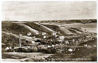
Fort San is a resort village in the Canadian province of Saskatchewan within Census Division No. 6. It is on the shores of Echo Lake of the Fishing Lakes in the Rural Municipality of North Qu'Appelle No. 187. It is 3 km (1.9 mi) west of Fort Qu'Appelle and approximately 77 km (48 mi) northeast of Regina.

Tantallon is a village in the Canadian province of Saskatchewan within the Rural Municipality of Spy Hill No. 152 and Census Division No. 5. It is in the Qu'Appelle Valley along the Qu'Appelle River about 39 km east of Round Lake (Saskatchewan). The community celebrated its centennial in 2004.

Tugaske is a village in the Canadian province of Saskatchewan within the Rural Municipality of Huron No. 223 and Census Division No. 7. It is nicknamed Gateway to Lake Diefenbaker. It is near Eyebrow Lake, a prairie lake in the Qu'Appelle Valley. It was named after an eyebrow-shaped hill also in the Qu'Appelle Valley above Eyebrow Lake. The lake, which is 9 km long and 1 km wide, is a bird sanctuary and is near Highway 627.

<span class="mw-page-title-main">Craven, Saskatchewan</span> Village in Saskatchewan

Craven is a village in the Canadian province of Saskatchewan within the Rural Municipality of Longlaketon No. 219 and Census Division No. 6. The village lies north-east of the town of Lumsden in the Qu'Appelle Valley. It sits at the confluence of the Qu'Appelle River and Last Mountain Creek. The Craven Dam is on the east side of the village.

B-Say-Tah is a resort village in the Canadian province of Saskatchewan within Census Division No. 6. It is on the shores of Echo Lake of the Fishing Lakes in the Rural Municipality of North Qu'Appelle No. 187. It is approximately 70 kilometres (43 mi) north-east of Regina and 5 kilometres (3.1 mi) west of Fort Qu'Appelle on Highway 210. Echo Valley Provincial Park is 2 kilometres (1.2 mi) to the west.

<span class="mw-page-title-main">Cochin, Saskatchewan</span> Resort Village in Saskatchewan, Canada

Cochin is a resort village in the Canadian province of Saskatchewan within Census Division No. 17. It is on the shores of Jackfish Lake in the Rural Municipality of Meota No. 468.

Mistusinne is a resort village in the Canadian province of Saskatchewan within Census Division No. 7. It is on the shores of Gordon McKenzie Arm of the South Saskatchewan River in the Rural Municipality of Maple Bush No. 224.

<span class="mw-page-title-main">Katepwa</span> Resort village in Saskatchewan, Canada

Katepwa is a resort village in the Canadian province of Saskatchewan within Census Division No. 6. It is on the eastern and southern shores of Katepwa Lake in the Rural Municipality of Abernethy No. 186. The name Katepwa likely comes from the Cree word Kahtapwao meaning "What is calling?" The name was given to the last in the chain of four lakes, Katepwa Lake. Legend has it that spirits inhabited the shores of the lake and First Nation people would hear voices on the lake.

<span class="mw-page-title-main">Rural Municipality of Lipton No. 217</span> Rural Municipality in Saskatchewan, Canada

The Rural Municipality of Lipton No. 217 is a rural municipality (RM) in the Canadian province of Saskatchewan within Census Division No. 6 and SARM Division No. 1.

References

  1. Lebret Village Council
  2. National Archives, Archivia Net, Post Offices and Postmasters, archived from the original on 6 October 2006
  3. Government of Saskatchewan, MRD Home, Municipal Directory System, archived from the original on 21 November 2008
  4. Canadian Textiles Institute. (2005), CTI Determine your provincial constituency, archived from the original on 11 September 2007
  5. Commissioner of Canada Elections, Chief Electoral Officer of Canada (2005), Elections Canada On-line, archived from the original on 21 April 2007
  6. 1 2 3 4 5 6 http://esask.uregina.ca/entry/lebret.html David McLennan, "Lebret" in The Encyclopedia of Saskatchewan. Viewed 14 October 2012.
  7. 1 2 "The History of Fort Qu'Appelle and the Area". Archived from the original on 20 October 2006. Retrieved 16 October 2006. "A Short History of Fort Qu'Appelle and Area," "Lebret." Viewed 14 October 2012.
  8. "Urban Municipality Incorporations". Saskatchewan Ministry of Government Relations. Archived from the original on 15 October 2014. Retrieved 1 June 2020.
  9. "Qu'Appelle - Stories From the San". Archived from the original on 10 August 2007. Retrieved 14 October 2012.
  10. http://esask.uregina.ca/entry/french_settlements.html Archived 2013-05-27 at the Wayback Machine Alan Anderson, "French Settlements" in The Encyclopedia of Saskatchewan. Viewed 14 October 2012.
  11. Adamson, Julia (16 February 2013). "Saskatchewan Roman Catholic Churches ~ Online Parish Registers ~ History". Saskatchewan Gen Web. Ancestry.com. Archived from the original on 19 April 2018. Retrieved 16 February 2013.
  12. "Saskatchewan Census Population" (PDF). Saskatchewan Bureau of Statistics. Archived from the original (PDF) on 24 September 2015. Retrieved 31 May 2020.
  13. "Saskatchewan Census Population". Saskatchewan Bureau of Statistics. Retrieved 31 May 2020.
  14. "Population and dwelling counts: Canada, provinces and territories, census divisions and census subdivisions (municipalities), Saskatchewan". Statistics Canada. 9 February 2022. Retrieved 1 April 2022.
  15. "Population and dwelling counts, for Canada, provinces and territories, and census subdivisions (municipalities), 2016 and 2011 censuses – 100% data (Saskatchewan)". Statistics Canada. 8 February 2017. Retrieved 30 May 2020.
  16. Population and Dwelling Counts, for Canada and Census Subdivisions (Municipalities), 2001 and 1996 Censuses - 100% Data