Atwater is a village in the Canadian province of Saskatchewan within the Rural Municipality of Fertile Belt No. 183 and Census Division No. 5. The village is approximately 45 kilometres (28 mi) southeast of the city of Melville on Highway 629.

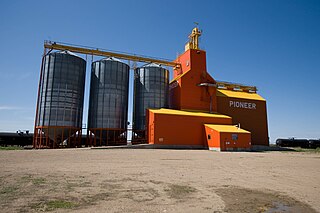
Consul is a village in the Canadian province of Saskatchewan within the Rural Municipality of Reno No. 51 and Census Division No. 4. The historic Red Coat Trail and Highway 21 pass through the village. The village features one of the last existing grain elevators in the region. It is 211 km southwest of the city of Swift Current.
Neudorf is a village in the Canadian province of Saskatchewan within the Rural Municipality of McLeod No. 185 and Census Division No. 5. It is on Highway 22 east of Lemberg, and Abernethy, and west of Killaly.

Climax is a village in the Canadian province of Saskatchewan within the Rural Municipality of Lone Tree No. 18 and Census Division No. 4. The village is located in the southwestern region of the province, just north of the U.S. border, situated on Highway 18 between Frontier and Canuck and on Highway 37 between Shaunavon and the Port of Climax.

Stewart Valley is a village in the Canadian province of Saskatchewan within the Rural Municipality of Saskatchewan Landing No. 167 and Census Division No. 8. It is on Highway 4, just south of the South Saskatchewan River, approximately 35 km (22 mi) north of the City of Swift Current in southern Saskatchewan. It is along the remains of the historic Swift Current-Battleford Trail.
Bangor is a village in the Canadian province of Saskatchewan within the Rural Municipality of Fertile Belt No. 183 and Census Division No. 5.
BulyeaBUUL-yay is a village in the Canadian province of Saskatchewan within the Rural Municipality of McKillop No. 220 and Census Division No. 6.
Dubuc is a village in the Canadian province of Saskatchewan within the Rural Municipality of Grayson No. 184 and Census Division No. 5. The village is located 55 kilometres south of the City of Yorkton and 30 km west of Esterhazy.
Fenwood is a village in the Canadian province of Saskatchewan within the Rural Municipality of Stanley No. 215 and Census Division No. 5.
Kincaid is a village in the Canadian province of Saskatchewan within the Rural Municipality of Pinto Creek No. 75 and Census Division No. 3.

Invermay is a village in the Canadian province of Saskatchewan within the Rural Municipality of Invermay No. 305 and Census Division No. 9. Invermay is about 50 km west of Canora or about 50 km east of Wadena on Highway 5.
Leask is a village in the Canadian province of Saskatchewan within the Rural Municipality of Leask No. 464 and Census Division No. 16. This village is 80 km (50 mi) southwest of Prince Albert. It is the administrative centre of the Mistawasis First Nation band government and the Rural Municipality of Leask No. 464.
MacNutt is a village in the Canadian province of Saskatchewan within the Rural Municipality of Churchbridge No. 211 and Census Division No. 5. The former District of Landestreu was renamed in 1909 to honour Thomas MacNutt, the area Member of the Legislative Assembly at the time. The village was settled between the late 1880s and the 1910s by immigrants of predominantly German origin.
Senlac is a village in the Canadian province of Saskatchewan within the Rural Municipality of Senlac No. 411 and Census Division No. 13. The village was named after Senlac Hill, the location of the Battle of Hastings in England in 1066.
Waldron is a village in the Canadian province of Saskatchewan within the Rural Municipality of Grayson No. 184 and Census Division No. 5.
Weekes is a village in the Canadian province of Saskatchewan within the Rural Municipality of Porcupine No. 395 and Census Division No. 14. The village is located 29 km east of the Town of Porcupine Plain on Highway 23.
Wiseton is a village in the Canadian province of Saskatchewan within the Rural Municipality of Milden No. 286 and Census Division No. 12. The village is located at the junction of Highway 44 and Highway 664 approximately 40 km southwest of Outlook.
Yarbo is a village in the Canadian province of Saskatchewan within the Rural Municipality of Langenburg No. 181 and Census Division No. 5. The village is located 24 km south of the Town of Churchbridge on Highway 80.
The Rural Municipality of Norton No. 69 is a rural municipality (RM) in the Canadian province of Saskatchewan within Census Division No. 2 and SARM Division No. 2. It is located in the southeast portion of the province.

The Rural Municipality of Chester No. 125 is a rural municipality (RM) in the Canadian province of Saskatchewan within Census Division No. 5 and SARM Division No. 1. It is located in the southeast portion of the province.

