Milden is a village in the Canadian province of Saskatchewan within the Rural Municipality of Milden No. 286 and Census Division No. 12. The village is located at the junction of Highway 15 and Highway 655 approximately 20 km west of Outlook on Highway 15.

Climax is a village in the Canadian province of Saskatchewan within the Rural Municipality of Lone Tree No. 18 and Census Division No. 4. The village is located in the southwestern region of the province, just north of the U.S. border, situated on Highway 18 between Frontier and Canuck and on Highway 37 between Shaunavon and the Port of Climax.

Stewart Valley is a village in the Canadian province of Saskatchewan within the Rural Municipality of Saskatchewan Landing No. 167 and Census Division No. 8. It is on Highway 4, just south of the South Saskatchewan River, approximately 35 km (22 mi) north of the City of Swift Current in southern Saskatchewan. It is along the remains of the historic Swift Current-Battleford Trail.

Vanguard is a village in the Canadian province of Saskatchewan within the Rural Municipality of Whiska Creek No. 106 and Census Division No. 3. It is on Highway 43 close to Notekeu Creek. Its prime economic driver is agriculture: chick peas; lentils; red, spring, hard and durum wheats are grown here.
Carievale is a village in the Canadian province of Saskatchewan within the Rural Municipality of Argyle No. 1 and Census Division No. 1. The village lies at the intersection of Highway 8 and Highway 18.
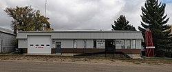
Denzil is a village in the Canadian province of Saskatchewan within the Rural Municipality of Eye Hill No. 382 and Census Division No. 13.
Dilke is a village in the Canadian province of Saskatchewan within the Rural Municipality of Sarnia No. 221 and Census Division No. 6.
Dorintosh is a village in the Canadian province of Saskatchewan within the Rural Municipality of Meadow Lake No. 588 and Census Division No. 17.
Flaxcombe is a village in the Canadian province of Saskatchewan within the Rural Municipality of Kindersley No. 290 and Census Division No. 13. The village is located approximately 30 km west of the Town of Kindersley, on Highway 7, and approximately 27 km east of the Alberta-Saskatchewan border.
Hazenmore is a village in the Canadian province of Saskatchewan within the Rural Municipality of Pinto Creek No. 75 and Census Division No. 3.
Kincaid is a village in the Canadian province of Saskatchewan within the Rural Municipality of Pinto Creek No. 75 and Census Division No. 3.

Kinley is a village in the Canadian province of Saskatchewan within the Rural Municipality of Perdue No. 346 and Census Division No. 12. The village of Kinley is located about 55 km west of the City of Saskatoon on Highway 14, between the communities of Perdue 10 km west and Asquith 17 km east.
Leross or is a village in the Canadian province of Saskatchewan within the Rural Municipality of Kellross No. 247 and Census Division No. 10.
Macrorie is a village in the Canadian province of Saskatchewan within the Rural Municipality of Fertile Valley No. 285 and Census Division No. 12. The village contains a Co-op gas and grocery store. Danielson Provincial Park is 20 km southeast on Highway 44.

Speers is a village in the Canadian province of Saskatchewan within the Rural Municipality of Douglas No. 436 and Census Division No. 16. The village is located approximately 50 minutes southeast of the City of North Battleford on Highway 40.
Spy Hill is a village in the Canadian province of Saskatchewan within the Rural Municipality of Spy Hill No. 152 and Census Division No. 5. It is at the intersection of Highway 8 and Highway 600. The community's school closed due to a lack of students, who are now bused approximately 27 km (17 mi) to Langenburg). The Northland Power - Spy Hill Power Plant is located in the community.

Tessier is a village in the Canadian province of Saskatchewan within the Rural Municipality of Harris No. 316 and Census Division No. 12. The village is located approximately 60 km southwest of the City of Saskatoon on Highway 7.
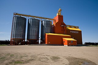
Osage is a village in the Canadian province of Saskatchewan within the Rural Municipality of Fillmore No. 96 and Census Division No. 2. The village is located on Highway 33, that runs south-east from Regina to Stoughton. The village has a grain elevator, post office, service station, and a two-sheet natural ice curling rink. Children from the area attend school in Fillmore, 13 km away. Osage celebrated its centennial in 2006.
Glen Harbour is a resort village in the Canadian province of Saskatchewan within Census Division No. 6. It is on the shores of Last Mountain Lake in the Rural Municipality of McKillop No. 220.

The Rural Municipality of Lac Pelletier No. 107 is a rural municipality (RM) in the Canadian province of Saskatchewan within Census Division No. 4 and SARM Division No. 3. It is located in the southwest portion of the province.