
Consul is a village in the Canadian province of Saskatchewan within the Rural Municipality of Reno No. 51 and Census Division No. 4. The historic Red Coat Trail and Highway 21 pass through the village. The village features one of the last existing grain elevators in the region. It is 211 km southwest of the city of Swift Current.

The Rural Municipality of Heart's Hill No. 352 is a rural municipality (RM) in the Canadian province of Saskatchewan within Census Division No. 13 and SARM Division No. 6. Located in the west-central portion of the province, it is adjacent to the Alberta boundary.
The Rural Municipality of Key West No. 70 is a rural municipality (RM) in the Canadian province of Saskatchewan within Census Division No. 2 and SARM Division No. 2. It is located in the southwest portion of the province.
Bjorkdale is a village in the Canadian province of Saskatchewan within the Rural Municipality of Bjorkdale No. 426 and Census Division No. 14. The village is located at the junctions of Highway 23, 679 & 776, approximately 78 kilometres (48 mi) east of the City of Melfort.

Bradwell is a village in the Canadian province of Saskatchewan within the Rural Municipality of Blucher No. 343 and Census Division No. 11. The village is located about 36 kilometres (22 mi) southeast of the city of Saskatoon on Highway 763. In 1936, during gravel excavations for a highway, the partial skeleton of a neolithic human male were discovered and named "Bradwell Man". A stone scraper and some eagle talons were found nearby.
Dubuc is a village in the Canadian province of Saskatchewan within the Rural Municipality of Grayson No. 184 and Census Division No. 5. The village is located 55 kilometres south of the City of Yorkton and 30 km west of Esterhazy.
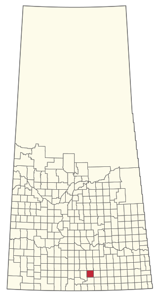
Hazenmore is a village in the Canadian province of Saskatchewan within the Rural Municipality of Pinto Creek No. 75 and Census Division No. 3.
Hyas is a village in the Canadian province of Saskatchewan within the Rural Municipality of Clayton No. 333 and Census Division No. 9.
Parkside is a village in the Canadian province of Saskatchewan within the Rural Municipality of Leask No. 464 and Census Division No. 16.

Sheho is a village in the Canadian province of Saskatchewan within the Rural Municipality of Insinger No. 275 and Census Division No. 9. Sheho is located on Saskatchewan Highway 16, in southeast Saskatchewan between Foam Lake to the west and the City of Yorkton to the east. Sheho Lake post office first opened in 1891 at the legal land description of Sec.28, Twp.30, R.9, W2 before moving slightly and changing name to Sheho.
St. Benedict is a village in the Canadian province of Saskatchewan within the Rural Municipality of Three Lakes No. 400 and Census Division No. 15. Located in the Carlton Trail Region of the province, it is 56 km (35 mi) north of the City of Humboldt off Highway 20.
Smeaton is a village in the Canadian province of Saskatchewan within the Rural Municipality of Torch River No. 488 and Census Division No. 14. It is at the foot of Hanson Lake Road, which ends at Creighton near Flin Flon, Manitoba). Narrow Hills Provincial Park is 70 km north.
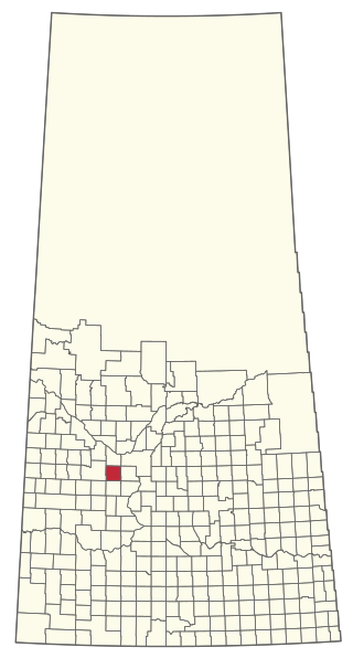
Shamrock is a village in the Canadian province of Saskatchewan within the Rural Municipality of Shamrock No. 134 and Census Division No. 7.
Silton is a village in the Canadian province of Saskatchewan within the Rural Municipality of McKillop No. 220 and Census Division No. 6.

Tessier is a village in the Canadian province of Saskatchewan within the Rural Municipality of Harris No. 316 and Census Division No. 12. The village is located approximately 60 km southwest of the City of Saskatoon on Highway 7.

Richard is a village in the Canadian province of Saskatchewan within the Rural Municipality of Douglas No. 436 and Census Division No. 16. It is approximately 48 km (30 mi) east of the City of North Battleford.
Tobin Lake is a resort village in the Canadian province of Saskatchewan within Census Division No. 14. It is on the shores of Tobin Lake in the Rural Municipality of Moose Range No. 486. It is approximately 34 km (21 mi) northeast of Nipawin at the end of Highway 255, which is accessed via Highway 55.

The Rural Municipality of Redburn No. 130 is a rural municipality (RM) in the Canadian province of Saskatchewan within Census Division No. 6 and SARM Division No. 2. It is located southeast of the city of Moose Jaw in the south-central portion region of the province.

The Rural Municipality of Brock No. 64 is a rural municipality (RM) in the Canadian province of Saskatchewan within Census Division No. 1 and SARM Division No. 1. It is located in the southeast portion of the province.
The Rural Municipality of Perdue No. 346 is a rural municipality (RM) in the Canadian province of Saskatchewan within Census Division No. 12 and SARM Division No. 5.


