Riverhurst

Last updated
Riverhurst
Village
Canada Saskatchewan location map.svg
Red pog.svg
Riverhurst
Canada location map 2.svg
Red pog.svg
Riverhurst
Coordinates: 50°33′00″N106°30′36″W / 50.5500°N 106.5100°W / 50.5500; -106.5100
Country Canada
Province Saskatchewan
Region Southwest
Census division 7
Rural Municipality Maple Bush
Government
  Governing bodyRiverhurst Village Council
Area
  Total124.8 km2 (48.2 sq mi)
Population
 (2016)
  Total130
  Density0.91/km2 (2.4/sq mi)
Time zone CST
Area code 306
Highways Highway 42
Website Village of Riverhurst
[1] [2] [3] [4]

Riverhurst (2016 population: 130) is a village in the Canadian province of Saskatchewan within the Rural Municipality of Maple Bush No. 224 and Census Division No. 7. It is in the southwest Coteau Hills area of the province, north of the Vermillion Hills. The community is located on Highway 42 east of Riverhurst Ferry. The village is primarily a farming community.

Contents

The name is a portmanteau of Riverside and Boldenhurst, two nearby post offices. [5]

History

Riverhurst incorporated as a village on June 22, 1916. [6]

Demographics

Population history
(1981–2016)
YearPop.±%
1981193    
1986180−6.7%
1991174−3.3%
1996 158−9.2%
2001 143−9.5%
2006 121−15.4%
2011 114−5.8%
2016 130+14.0%
Source: Statistics Canada via Saskatchewan Bureau of Statistics [7] [8]

In the 2021 Census of Population conducted by Statistics Canada, Riverhurst had a population of 152 living in 74 of its 131 total private dwellings, a change of

In the 2016 Census of Population, the Village of Riverhurst recorded a population of 130 living in 69 of its 114 total private dwellings, a

Infrastructure

Riverhurst is situated close to the east bank of Lake Diefenbaker, and is the location of the Riverhurst Ferry, a cable ferry that crosses to Lucky Lake on the west bank. Highway 42 (which provides access to the community) crosses Lake Diefenbaker by the Riverhurst Ferry. The village is located 8 km south of the Elbow crater.

Notable residents

Royal Canadian Mounted Police Constable Thomas Brian King (who was shot to death in Saskatoon) lived in Riverhurst.

Curtis Voth, who played Semi-Professional Hockey is from Riverhurst.

See also

Related Research Articles

Aquadeo is a resort village in the Canadian province of Saskatchewan within Census Division No. 17. It is on the shores of Jackfish Lake in the Rural Municipality of Meota No. 468. It is approximately 40 kilometres (25 mi) north of North Battleford.

<span class="mw-page-title-main">Rural Municipality of Maple Bush No. 224</span> Rural municipality in Saskatchewan, Canada

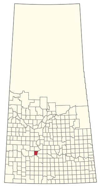
The Rural Municipality of Maple Bush No. 224 is a rural municipality (RM) in the Canadian province of Saskatchewan within Census Division No. 7 and SARM Division No. 2. It is located in the southwest portion of the province.

<span class="mw-page-title-main">Rural Municipality of Blaine Lake No. 434</span> Rural municipality in Saskatchewan, Canada

The Rural Municipality of Blaine Lake No. 434 is a rural municipality (RM) in the Canadian province of Saskatchewan within Census Division No. 16 and SARM Division No. 5. The RM extends east to the North Saskatchewan River and north to the village of Marcelin.

<span class="mw-page-title-main">Eyebrow, Saskatchewan</span> Village in Saskatchewan, Canada

Eyebrow is a village in the Canadian province of Saskatchewan within the Rural Municipality of Eyebrow No. 193 and Census Division No. 7. The community originated at the location that is now the abandoned community of Eskbank several kilometres to the south. Eyebrow is located at the intersection of Highway 367 and Highway 42; 84 km northwest of Moose Jaw, 154 km northwest of Regina and 196 km south of Saskatoon.

<span class="mw-page-title-main">Rural Municipality of Baildon No. 131</span> Rural municipality in Saskatchewan, Canada

The Rural Municipality of Baildon No. 131 is a rural municipality (RM) in the Canadian province of Saskatchewan within Census Division No. 7 and SARM Division No. 2. It is located in the south-central portion of the province south of Moose Jaw.

Dorintosh is a village in the Canadian province of Saskatchewan within the Rural Municipality of Meadow Lake No. 588 and Census Division No. 17.

<span class="mw-page-title-main">Loreburn, Saskatchewan</span> Village in Saskatchewan, Canada

Loreburn is a village in the Canadian province of Saskatchewan within the Rural Municipality of Loreburn No. 254 and Census Division No. 11. The village is about 16 kilometres (9.9 mi) north of Elbow and 16 kilometres (9.9 mi) south-east of Danielson Provincial Park, which is located near Gardiner Dam, Lake Diefenbaker.

<span class="mw-page-title-main">Lucky Lake</span> Village in Saskatchewan, Canada

Lucky Lake is a village in the Canadian province of Saskatchewan within the Rural Municipality of Canaan No. 225 and Census Division No. 7. The Village is located at the junction of Highway 42, Highway 45 and Highway 646 approximately 90 km northeast of Swift Current, Saskatchewan.

<span class="mw-page-title-main">Rural Municipality of Victory No. 226</span> Rural municipality in Saskatchewan, Canada

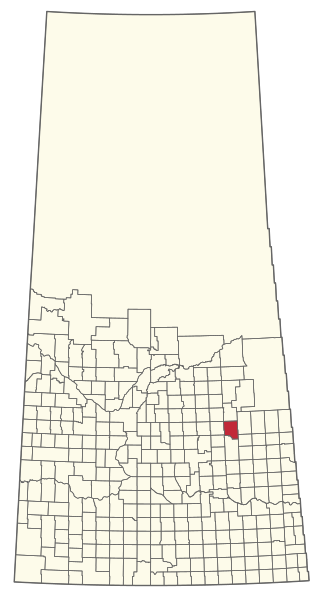
The Rural Municipality of Victory No. 226 is a rural municipality (RM) in the Canadian province of Saskatchewan within Census Division No. 7 and SARM Division No. 3.

Tugaske is a village in the Canadian province of Saskatchewan within the Rural Municipality of Huron No. 223 and Census Division No. 7. It is nicknamed Gateway to Lake Diefenbaker. It is near Eyebrow Lake, a prairie lake in the Qu'Appelle Valley. It was named after an eyebrow-shaped hill also in the Qu'Appelle Valley above Eyebrow Lake. The lake, which is 9 km long and 1 km wide, is a bird sanctuary and is near Highway 627.

Chitek Lake is a resort village in the Canadian province of Saskatchewan within Census Division No. 16. It is on the shores of Chitek Lake in the Rural Municipality of Big River No. 555. It is approximately 230 kilometres (140 mi) northwest of Saskatoon, 115 kilometres (71 mi) northeast of North Battleford, and 120 kilometres (75 mi) west of Prince Albert. The Pelican Lake First Nation reserve borders the resort village.

Coteau Beach is a resort village in the Canadian province of Saskatchewan within Census Division No. 7. It is on the western shore of the Thompson Arm of Lake Diefenbaker in the Rural Municipality of Coteau No. 255. It is 10 kilometres (6.2 mi) east of Highway 45 and approximately 40 kilometres (25 mi) southeast of the town of Outlook.

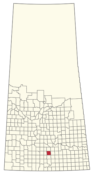
Mistusinne is a resort village in the Canadian province of Saskatchewan within Census Division No. 7. It is on the shores of Gordon McKenzie Arm of Lake Diefenbaker in the Rural Municipality of Maple Bush No. 224.

<span class="mw-page-title-main">Rural Municipality of Wawken No. 93</span> Rural municipality in Saskatchewan, Canada

The Rural Municipality of Wawken No. 93 is a rural municipality (RM) in the Canadian province of Saskatchewan within Census Division No. 1 and SARM Division No. 1. It is located in the southeast portion of the province.

<span class="mw-page-title-main">Rural Municipality of Riverside No. 168</span> Rural municipality in Saskatchewan, Canada

The Rural Municipality of Riverside No. 168 is a rural municipality (RM) in the Canadian province of Saskatchewan within Census Division No. 8 and SARM Division No. 3.

<span class="mw-page-title-main">Rural Municipality of Canaan No. 225</span> Rural Municipality in Saskatchewan, Canada

The Rural Municipality of Canaan No. 225 is a rural municipality (RM) in the Canadian province of Saskatchewan within Census Division No. 7 and SARM Division No. 3.

<span class="mw-page-title-main">Rural Municipality of Fish Creek No. 402</span> Rural municipality in Saskatchewan, Canada

The Rural Municipality of Fish Creek No. 402 is a rural municipality (RM) in the Canadian province of Saskatchewan within Census Division No. 15 and SARM Division No. 5.

<span class="mw-page-title-main">Rural Municipality of Coteau No. 255</span> Rural municipality in Saskatchewan, Canada

The Rural Municipality of Coteau No. 255 is a rural municipality (RM) in the Canadian province of Saskatchewan within Census Division No. 7 and SARM Division No. 3.

<span class="mw-page-title-main">Rural Municipality of Prince Albert No. 461</span> Rural municipality in Saskatchewan, Canada

The Rural Municipality of Prince Albert No. 461 is a rural municipality (RM) in the Canadian province of Saskatchewan within Census Division No. 15 and SARM Division No. 5. The RM lies between the North Saskatchewan River and the South Saskatchewan River, and is located south of Prince Albert.

<span class="mw-page-title-main">Rural Municipality of Sasman No. 336</span> Rural municipality in Saskatchewan, Canada

The Rural Municipality of Sasman No. 336 is a rural municipality (RM) in the Canadian province of Saskatchewan within Census Division No. 10 and SARM Division No. 4.

References

  1. National Archives, Archivia Net. "Post Offices and Postmasters".
  2. Government of Saskatchewan, MRD Home. "Municipal Directory System". Archived from the original on November 21, 2008.
  3. Canadian Textiles Institute. (2005). "CTI Determine your provincial constituency". Archived from the original on 2007-09-11.
  4. Commissioner of Canada Elections, Chief Electoral Officer of Canada (2005). "Elections Canada On-line".
  5. Barry, Bill (September 2005). Geographic Names of Saskatchewan . Regina, Saskatchewan: People Places Publishing, Ltd. p.  358. ISBN   1-897010-19-2.
  6. "Urban Municipality Incorporations". Saskatchewan Ministry of Government Relations. Archived from the original on October 15, 2014. Retrieved June 1, 2020.
  7. "Saskatchewan Census Population" (PDF). Saskatchewan Bureau of Statistics. Archived from the original (PDF) on September 24, 2015. Retrieved May 31, 2020.
  8. "Saskatchewan Census Population". Saskatchewan Bureau of Statistics. Retrieved May 31, 2020.
  9. "Population and dwelling counts: Canada, provinces and territories, census divisions and census subdivisions (municipalities), Saskatchewan". Statistics Canada. February 9, 2022. Retrieved April 1, 2022.
  10. "Population and dwelling counts, for Canada, provinces and territories, and census subdivisions (municipalities), 2016 and 2011 censuses – 100% data (Saskatchewan)". Statistics Canada. February 8, 2017. Retrieved May 30, 2020.