
Unity is a town in the western part of the Canadian province of Saskatchewan with a population of almost 2600. Unity is located at the intersection of Highway 14 and Highway 21, and the intersection of the CNR and CPR main rail lines. Unity is located 200 km west-northwest of Saskatoon, Saskatchewan, and 375 km southeast of Edmonton, Alberta. The town of Wilkie is located 18.96 miles (30.51 km) to the east.

St. Walburg is a town in west-central Saskatchewan's prairie region on Saskatchewan Highway 26. St. Walburg is surrounded by the Rural Municipality of Frenchman Butte No. 501. The Bronson Provincial Forest is 10 kilometres (6.2 mi) to the north.

Kenaston is a village within the rural municipality of McCraney No. 282, in the province of Saskatchewan, Canada. Kenaston is located on Highway 11 at the junction of Highway 15 and is also near Highway 19. This is a scenic area of Saskatchewan situated within the rolling Allan Hills. Kenaston is located between Danielson Provincial Park and Blackstrap Provincial Park. The village population according to the 2016 Canada Census was 282 persons,.

Dundurn is a town of 647 residents in the rural municipality of Dundurn No. 314, in the Canadian province of Saskatchewan. Dundurn is located on Highway 11 or Louis Riel Trail in central Saskatchewan, about 42 km south of Saskatoon. As well as being an agricultural town, it is also a bedroom community for both Camp Dundurn and Saskatoon.

Central Butte is a town in Saskatchewan, Canada, approximately 200 kilometres from Saskatoon, Regina and Swift Current and 100 kilometres from Moose Jaw. Thunder Creek, a river that flows into Moose Jaw, begins south of the community. The town is served by the Central Butte Airport.
Fleming is a town in Saskatchewan, Canada. As of the 2011 census, with a population of 83 inhabitants, Fleming was, by population, the second smallest official town in Saskatchewan. It is bordered primarily by the Rural Municipality of Moosomin No. 121, but also by the Rural Municipality of Maryfield No. 91.

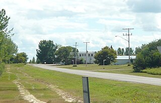
Bladworth is a village within the Rural Municipality of McCraney No. 282, Saskatchewan, Canada. The village is located 99 kilometres (62 mi) south of the city of Saskatoon on Highway 11.

Eyebrow is a village in the Canadian province of Saskatchewan. The community originated at the location that is now the abandoned village of Eskbank several kilometers south. Eyebrow is located at the intersection of Highway 367 and Highway 42. The village is 84 km northwest of Moose Jaw, 154 km northwest of Regina and 196 km south of Saskatoon.
Elstow is a special service area within the Rural Municipality of Blucher No. 343 in Saskatchewan, Canada. It dissolved from village status on December 31, 2014. It was originally incorporated as a village on December 17, 1908.
Goodeve is a village within the Rural Municipality of Stanley No. 215, in the province of Saskatchewan, Canada. The village is the administrative headquarters of the Little Black Bear Cree First Nation band government. The village had a population of 40 in the 2016 Canada Census,.

Glenside is a village within the Rural Municipality of Rudy No. 284, in the province of Saskatchewan, Canada. The village is located on Highway 219 approximately 10 km east of the Town of Outlook. The village had a population of 76 in the 2016 Canada Census,.
Hawarden is a village in the Rural Municipality of Loreburn No. 254, in the province of Saskatchewan, Canada. The village had a population of 52 in the 2016 Canada Census,. The village is located on Highway 19 north of Strongfield, Loreburn, and Elbow.
Parkbeg is a hamlet in Wheatlands Rural Municipality No. 163, Saskatchewan, Canada. The hamlet is located at the junction of Highway 1 and Highway 627 approximately 58 km directly west of the City of Moose Jaw on the Trans Canada Highway.
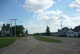
Plunkett is a village in the Canadian province of Saskatchewan.
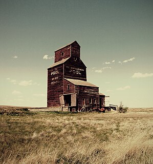
Bents is an unincorporated community in Marriott No. 317, Saskatchewan, Canada. Prior to the town being founded the area was referred to as Piche. Bents took its name from Longniddry Bents in Scotland. Its derelict wooden grain elevator was once the subject of a National Geographic photograph. The remnants of the town are now located on private property.
St. Boswells is a hamlet in Glen Bain Rural Municipality No. 105, Saskatchewan, Canada. The hamlet is about 8 km east of Highway 19, about 25 km northwest of the town of Gravelbourg. Very little remains of the former village except a well known as the best water around, and sidewalks which mark the once prosperous business section of St. Boswells.
Quantock is an unincorporated area of Saskatchewan, Canada. According to a book titled Saskatchewan Ghost Towns, it was the location of a post office intended to serve isolated farmers and ranchers. Its mail route came from the nearby community of Assiniboia. It is located near the border with Montana, southwest of Regina.
Coteau Beach is Resort Village in Coteau No. 255, Saskatchewan, Canada. The population was 30 at the 2006 Census. The village is located approximately 10 km east of Highway 45 on the west shore of Thomson Arm approximately 40 km south-east of the Town of Outlook.
Allan Hills is an unincorporated community in Lost River Rural Municipality No. 313, Saskatchewan, Canada. The community is located on Highway 665, 12 km south of the town of Allan.

Lemsford is an unincorporated hamlet in Clinworth Rural Municipality No. 230, Saskatchewan, Canada. It previously held the status of village until January 1, 1951. The hamlet is located 42 km east of the Town of Leader at the intersection of Highway 32 and Highway 649, the hamlet is also serviced by the Great Western Railway.


