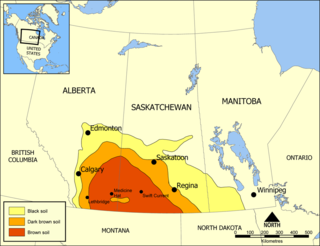
The Coteau du Missouri, or Missouri Plateau, is a large plateau that stretches along the eastern side of the valley of the Missouri River in central North Dakota and north-central South Dakota in the United States. In the Canadian provinces of Saskatchewan and Alberta this physiographic region is classified as the uplands Missouri Coteau, which is a part of the Great Plains Province or Alberta Plateau Region, which extends across the southwest corner of the province of Saskatchewan as well as the southeast corner of the province of Alberta. Historically, in Canada the area was known as the Palliser's Triangle regarded as an extension of the Great American Desert and unsuitable for agriculture and thus designated by Canadian geographer and explorer John Palliser. The terrain of the Missouri Coteau features low hummocky, undulating, rolling hills, potholes, and grasslands.
Morse is a former provincial electoral division for the Legislative Assembly of the province of Saskatchewan, Canada, centered on the town of Morse, Saskatchewan. The district was created before the 3rd Saskatchewan general election in 1912, and abolished before the 23rd Saskatchewan general election in 1995. It was the riding of Premier Ross Thatcher.

Beechy is a village within the Rural Municipality of Victory No. 226, Saskatchewan, Canada. The village is located in the Coteau Hills region of the province, at the intersection of Highway 342 and Highway 737. As of 2006, the village's population is 243.
Big Stick No. 141 is a rural municipality in the Canadian province of Saskatchewan. Big Stick No.141 is located in South West Ceneral Saskatchewan, in SARM Division 3. The village of Golden Prairie lies within its geographical boundaries, but is technically not part of Big Stick No 141.

Morse is a town in southern Saskatchewan, Canada. It is situated on the Trans Canada Highway near the north shore of Reed Lake. The town is named after the American scholar and inventor Samuel Morse, best known for the invention of the telegraph based on the European telegraph system. Although he was an American, he left a large enough impression that the town was named after him.
Val Marie No. 17 is a rural municipality in the Canadian province of Saskatchewan, located in the southwestern part of the province on the United States border. It includes the western portion of Grasslands National Park in its southeastern portion. The RM lies adjacent to the United States border at Phillips County, Montana. It is part of Division No. 4, Saskatchewan.

Golden Prairie is a village within the Rural Municipality of Big Stick No. 141, in the province of Saskatchewan, Canada. The village had a population of 30 in the 2016 Canada Census,.
Main Centre is a hamlet in the Canadian province of Saskatchewan. Listed as a designated place by Statistics Canada, the hamlet had a reported population of 5 living in 3 of its 4 total private dwellings in the Canada 2011 Census.

Blumenhof is an unincorporated community within the Rural Municipality of Lac Pelletier No. 107, Saskatchewan, Canada.

Rosenhof is a hamlet in Coulee Rural Municipality No. 136, Saskatchewan, Canada. The hamlet is located on Range Rd. 123 4 km south of Highway 363, about 15 km south of Swift Current.

Burnham is an unincorporated community in Coulee Rural Municipality No. 136, Saskatchewan, Canada. The community is located on Highway 628, approximately 9 km (5.6 mi) north of Highway 363 and 15 km (9.3 mi) south of Swift Current.

Rheinfeld is a hamlet in Coulee Rural Municipality No. 136, Saskatchewan, Canada. The hamlet is located on Highway 628 9 km north of Highway 363, about 15 km south of Swift Current.

McMahon is a hamlet in Coulee Rural Municipality No. 136, Saskatchewan, Canada. The hamlet is located on Saskatchewan Highway 379, about 40 km southeast of Swift Current.

Braddock is an unincorporated community in Coulee Rural Municipality No. 136, Saskatchewan, Canada. The community is located on Highway 721, about 35 km (22 mi) southeast of Swift Current.

South Gnadenthal is a hamlet in Coulee Rural Municipality No. 136, Saskatchewan, Canada. The hamlet is located on Highway 721, about 35 km southeast of Swift Current.

Schoenwiese is a hamlet in Swift Current Rural Municipality No. 137, Saskatchewan, Canada. The hamlet is located on Highway 628 about 2 km north of Highway 379, about 15 km south of Swift Current.
Saskatchewan Landing No. 167 is a rural municipality in Saskatchewan, Canada encompassing 797.52 square kilometers in area. The rural municipality maintains its office in Stewart Valley, Saskatchewan. The rural municipality in conjunction with the provincial government is in charge of maintenance of highways in its area. As well, the municipality provides policing, fire protection and municipal governance for the rural district, with a reeve as its administrator. The Saskatchewan Landing Provincial Park is located within the rural municipality. Agriculture is the major industry in the rural municipality.

Harris No. 316 is a rural municipality in the Canadian province of Saskatchewan, located in Census Division 12. The seat of the municipality is located in the Village of Harris.
Gouldtown is a hamlet in the Canadian province of Saskatchewan located in Morse No. 165. It is located 12 miles north of Herbert. Gouldtown is home to approximately 10 people. Its amenities include a post office and well.
Leinan is a locality in Saskatchewan Landing Rural Municipality No. 167 in the province of Saskatchewan, Canada. It is located east of highway 4 on Township Road 175, approximately 24 km north of Swift Current.


