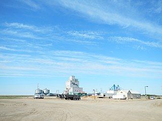
Hodgeville is a village mayor Kyle Hall within the Rural Municipality of Lawtonia No. 135, in the province of Saskatchewan, Canada. The village is located approximately 34 km south of the Trans Canada Highway, 97 km southeast of the City of Swift Current. It has a population of approximately 172. The village was incorporated in June, 1921.

Brownlee is a village within the Rural Municipality of Eyebrow No. 193, Saskatchewan, Canada. The village is located approximately 58 km northwest of the city of Moose Jaw on Highway 42.

Dafoe is a village within the Rural Municipality of Big Quill No. 308, Saskatchewan, Canada. The village had a population of 15 in the 2016 Census. The village is located east of the intersection of Highway 6 and the Yellowhead Highway southwest of Big Quill Lake, the Dafoe Brook flows to the east of the village. Dafoe marks the far west end of the area known to Icelandic settlers in Saskatchewan as the Lakes Settlement.

Denholm is a village within the Rural Municipality of Mayfield No. 406, Saskatchewan, Canada. The village had a population of 88 in the 2016 Census,.

Dilke is a village within the Rural Municipality of Sarnia No. 221, Saskatchewan, Canada. The village had a population of 98 in the 2016 Census,.

Dinsmore is a village within the Rural Municipality of Milden No. 286, Saskatchewan, Canada. The village had a population of 289 in the 2016 Census,.

Dysart is a village within the Rural Municipality of Lipton No. 217, in the province of Saskatchewan, Canada. The village is located east of Cupar, and northwest of Lipton. It is about 91 km north of the capital, Regina. The village was named for Dysart, Fife in Scotland.

Dubuc (Dew'buck) is a village within the Rural Municipality of Grayson No. 184, in the province of Saskatchewan, Canada. The village is located 55km south of the city of Yorkton and 30 km West of Esterhazy. The village had a population of 61 in the 2016 Canada Census,.

Flaxcombe is a village within the Rural Municipality of Kindersley No. 290, Saskatchewan, Canada. The village is located approximately 30 km west of the town of Kindersley, on Highway 7, and approximately 27 km east of the Alberta-Saskatchewan border.

Fenwood is a village within the Rural Municipality of Stanley No. 215, in the province of Saskatchewan, Canada. The village had a population of 30 in the 2016 Canada Census,.

Gerald is a village within the Rural Municipality of Spy Hill No. 152, in the province of Saskatchewan, Canada. The village had a population of 136 in the 2016 Canada Census,.

Holdfast is a village within the Rural Municipality of in the province of Saskatchewan, Canada. The village had a population of 247 in the 2016 Canada Census,. The village is located 2 km east of Highway 2 on Highway 732, about 97.6 km northwest of the City of Regina.

Tramping Lake is a village in the Rural Municipality of Mariposa No. 350, Saskatchewan, Canada. The village gets its name from nearby Tramping Lake.

Lake Lenore is a village within the Rural Municipality of St. Peter No. 369, in the province of Saskatchewan, Canada. The village is located 144.6 km north-east of the city of Saskatoon. Outside of the village is a lake that shares its name, Lake Lenore, renowned for its fishing activity as well the Rural Municipality of Lake Lenore No. 399 to the north. Lake Lenore possesses a fully operational school, Co-op Grocery and Agro Service Station and also contains a Credit Union and Public Library. The village had a population of 284 in the 2016 Canada Census,.

Lancer is a village with in the Rural Municipality of Miry Creek No. 229, in the province of Saskatchewan, Canada. Lancer had a population of 69 in the 2016 Canada Census,.

Lang is a village within the Rural Municipality of Scott No. 98, in the province of Saskatchewan, Canada. The village is located approximately 70 km south east of the capital, Regina. Lang had a population of 189 in the 2016 Canada Census.

Lipton is a village in the Rural Municipality of Lipton No. 217, in the province of Saskatchewan, Canada. Lipton had a population of 372 in the 2016 Canada Census,. The village is located 17 km (11 mi) north of the Town of Fort Qu'Appelle on highway 22.

Mantario is a special service area in the Rural Municipality of Chesterfield No. 261 in the Canadian province of Saskatchewan.It held village status prior to June 30, 2007. The population was 5 people in 2011. The community is located 70 km southwest of the Town of Kindersley on Highway 44.

Mervin is a village in the Canadian province of Saskatchewan.

Beaver Flat is a resort village within the Rural Municipality of Excelsior No. 166, in the province of Saskatchewan, Canada. Bever Flat is located on the south shore of Lake Diefenbaker at the end of Highway 628, approximately 57 km (35 mi) north of Swift Current.


