St. Louis is a village in the Canadian province of Saskatchewan within the Rural Municipality of St. Louis No. 431 and Census Division No. 15. It is south of the City of Prince Albert and northeast of Batoche.

Czar is a village in central Alberta, Canada. It is 70 kilometres (43 mi) west of the Saskatchewan border, at the intersection of Highway 13, Buffalo Trail, and the Canadian Pacific Kansas City tracks.

The Rural Municipality of Marquis No. 191 is a rural municipality (RM) in the Canadian province of Saskatchewan within Census Division No. 7 and SARM Division No. 2. It is located in the south-central portion of the province.

The Rural Municipality of Moose Jaw No. 161 is a rural municipality (RM) in the Canadian province of Saskatchewan within Census Division No. 7 and SARM Division No. 2. It is located in the south-central portion of the province, surrounding the city of Moose Jaw.

Stewart Valley is a village in the Canadian province of Saskatchewan within the Rural Municipality of Saskatchewan Landing No. 167 and Census Division No. 8. It is on Highway 4, just south of the South Saskatchewan River, approximately 35 km (22 mi) north of the City of Swift Current in southern Saskatchewan. It is along the remains of the historic Swift Current-Battleford Trail.

Belle Plaine is a village in the Canadian province of Saskatchewan within the Rural Municipality of Pense No. 160 and Census Division No. 6. Belle Plaine is located on Highway 1, 21 kilometres east of the City of Moose Jaw in south-central Saskatchewan. Buffalo Pound Provincial Park and Regina Beach are located near Belle Plaine.
Marquis is a village in the Canadian province of Saskatchewan within the Rural Municipality of Marquis No. 191 and Census Division No. 7. It is on Highway 42 about 32 km northwest of Moose Jaw.

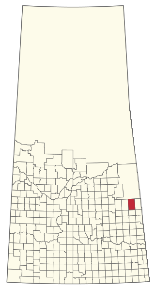
Carievale is a village in the Canadian province of Saskatchewan within the Rural Municipality of Argyle No. 1 and Census Division No. 1. The village lies at the intersection of Highway 8 and Highway 18.

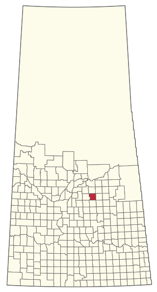
Bradwell is a village in the Canadian province of Saskatchewan within the Rural Municipality of Blucher No. 343 and Census Division No. 11. The village is located about 36 kilometres (22 mi) southeast of the city of Saskatoon on Highway 763. In 1936, during gravel excavations for a highway, the partial skeleton of a neolithic human male were discovered and named "Bradwell Man". A stone scraper and some eagle talons were found nearby.

Disley is a village in the Canadian province of Saskatchewan within the Rural Municipality of Lumsden No. 189 and Census Division No. 6. It is located 18 km (11 mi) west of Lumsden just south of the Louis Riel Trail and 48 kilometres northwest of the City of Regina.

Meacham is a village in the Canadian province of Saskatchewan within the Rural Municipality of Colonsay No. 342 and Census Division No. 11. It is located 69 kilometres east of the City of Saskatoon on Highway 2.
Meath Park is a village in the Canadian province of Saskatchewan within the Rural Municipality of Garden River No. 490 and Census Division No. 15.
Middle Lake is a village in the Canadian province of Saskatchewan within the Rural Municipality of Three Lakes No. 400 and Census Division No. 15. The village has a public K-12 school, a nursing home, and a regional park. It is adjacent to Lucien Lake and accessed from Highway 20. The surrounding area is largely agricultural.
Plunkett is a special service area in the Canadian province of Saskatchewan within the Rural Municipality of Viscount No. 341 and Census Division No. 11. It held village status between 1921 and 2022.

The Rural Municipality of Golden West No. 95 is a rural municipality (RM) in the Canadian province of Saskatchewan within Census Division No. 1 and SARM Division No. 1. It is located in the southeast portion of the province.

The Rural Municipality of Rodgers No. 133 is a rural municipality (RM) in the Canadian province of Saskatchewan within Census Division No. 7 and SARM Division No. 2.
The Rural Municipality of Clayton No. 333 is a rural municipality (RM) in the Canadian province of Saskatchewan within Census Division No. 9 and SARM Division No. 4.

The Rural Municipality of Hillsdale No. 440 is a rural municipality (RM) in the Canadian province of Saskatchewan within Census Division No. 13 and SARM Division No. 6.
The Rural Municipality of Lake Lenore No. 399 is a rural municipality (RM) in the Canadian province of Saskatchewan within Census Division No. 15 and SARM Division No. 5.

The Rural Municipality of Pleasantdale No. 398 is a rural municipality (RM) in the Canadian province of Saskatchewan within Census Division No. 14 and SARM Division No. 4.


