
Edam is a village in the Canadian province of Saskatchewan within the Rural Municipality of Turtle River No. 469 and Census Division No. 17. Edam is located off Highway 26, south of Turtleford and north of Vawn.

Loon Lake is a village in the Canadian province of Saskatchewan within the Rural Municipality of Loon Lake No. 561 and Census Division No. 17. The Makwa Sahgaiehcan First Nation reserve is to the east of the village. The village is located on Highway 26 north-east of the city of Lloydminster.
Storthoaks is a village in the Canadian province of Saskatchewan within the Rural Municipality of Storthoaks No. 31 and Census Division No. 1. The village is located approximately 129 km east of the City of Estevan on Highway 361 and 16 km west of the Saskatchewan-Manitoba border.

The Rural Municipality of Bone Creek No. 108 is a rural municipality (RM) in the Canadian province of Saskatchewan within Census Division No. 4 and SARM Division No. 3. It is located in the southwest portion of the province.
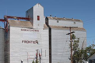
Frontier is a village in the Canadian province of Saskatchewan within the Rural Municipality of Frontier No. 19 and Census Division No. 4. Frontier is on Highway 18 and is served by the Frontier Airport located (3.7 km) south of the village.
Bjorkdale is a village in the Canadian province of Saskatchewan within the Rural Municipality of Bjorkdale No. 426 and Census Division No. 14. The village is located at the junctions of Highway 23, 679 & 776, approximately 78 kilometres (48 mi) east of the City of Melfort.

Denholm is a village in the Canadian province of Saskatchewan within the Rural Municipality of Mayfield No. 406 and Census Division No. 16.
Dorintosh is a village in the Canadian province of Saskatchewan within the Rural Municipality of Meadow Lake No. 588 and Census Division No. 17.
Glaslyn is a village in the Canadian province of Saskatchewan within the Rural Municipality of Parkdale No. 498 and Census Division No. 17. The village is located 67 km north of the City of North Battleford and 91 km south of Meadow Lake at the intersection of Highway 4 and Highway 3.
Medstead is a village in the Canadian province of Saskatchewan within the Rural Municipality of Medstead No. 497 and Census Division No. 16.
Parkside is a village in the Canadian province of Saskatchewan within the Rural Municipality of Leask No. 464 and Census Division No. 16.
St. Benedict is a village in the Canadian province of Saskatchewan within the Rural Municipality of Three Lakes No. 400 and Census Division No. 15. Located in the Carlton Trail Region of the province, it is 56 km (35 mi) north of the City of Humboldt off Highway 20.
Smeaton is a village in the Canadian province of Saskatchewan within the Rural Municipality of Torch River No. 488 and Census Division No. 14. It is at the foot of Hanson Lake Road, which ends at Creighton near Flin Flon, Manitoba). Narrow Hills Provincial Park is 70 km north.
Silton is a village in the Canadian province of Saskatchewan within the Rural Municipality of McKillop No. 220 and Census Division No. 6.
Success is a special service area in the Canadian province of Saskatchewan within the Rural Municipality of Riverside No. 168 and Census Division No. 8. It held village status between 1912 and 2022.
Tantallon is a village in the Canadian province of Saskatchewan within the Rural Municipality of Spy Hill No. 152 and Census Division No. 5. It is in the Qu'Appelle Valley along the Qu'Appelle River about 39 km east of Round Lake (Saskatchewan). The community celebrated its centennial in 2004.
Yarbo is a village in the Canadian province of Saskatchewan within the Rural Municipality of Langenburg No. 181 and Census Division No. 5. The village is located 24 km south of the Town of Churchbridge on Highway 80.
Wakaw Lake is a resort village in the Canadian province of Saskatchewan within Census Division No. 15. It is on the shores of Wakaw Lake in the Rural Municipality of Hoodoo No. 401. It is on Highway 41 approximately 86 kilometres (53 mi) north-east of Saskatoon and 63 kilometres (39 mi) south of Prince Albert.

The Rural Municipality of Big River No. 555 is a rural municipality (RM) in the Canadian province of Saskatchewan within Census Division No. 16 and SARM Division No. 5.

The Rural Municipality of Loon Lake No. 561 is a rural municipality (RM) in the Canadian province of Saskatchewan within Census Division No. 17 and SARM Division No. 6.


