Makwa Lake

Last updated

Makwa Lake
Canada Saskatchewan relief location map.jpg
Red pog.svg
Makwa Lake
Location in Saskatchewan
Canada relief map 2.svg
Red pog.svg
Makwa Lake
Makwa Lake (Canada)
Location RM of Loon Lake No. 561, Flag of Saskatchewan.svg  Saskatchewan
Coordinates 54°04′00″N109°15′03″W / 54.0668°N 109.2507°W / 54.0668; -109.2507
Primary inflows Ministikwan Creek
Primary outflows Makwa River
Basin  countriesFlag of Canada (Pantone).svg  Canada
Surface area3,186.4[ convert: needs unit name ]
Max. depth27.5 m (90 ft)
Shore length167.9 km (42.2 mi)
Surface elevation524 m (1,719 ft)
Settlements Loon Lake
1 Shore length is not a well-defined measure.

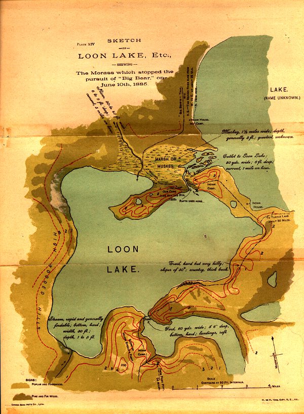
Makwa Lake, [1] which is Cree for Loon Lake, is a lake in the west-central region of the Canadian province of Saskatchewan in the transition zone between parkland and boreal forest. The Battle of Loon Lake, which was last battle of the North-West Rebellion, happened at Steele Narrows, [2] a strait at the entrance to Sanderson Bay on Makwa Lake. The site is now part of Steele Narrows Provincial Park.

Contents

Makwa Lake is home to a section of Makwa Lake Provincial Park, two Fist Nations (Thunderchild and Makwa Sahgaiehcan), and two communities (Loon Lake and Pine Cove [3] ). Pine Cove and Loon Lake are along the eastern shore and accessed from Highway 26 while Highway 699 runs along the southern shore and provides access to both provincial parks. The two First Nations each have two Indian reserves at the lake: Thunderchild 115S, Thunderchild 115Z, Makwa Lake 129, and Makwa Lake 129B. [4] At the lake's outflow, at the north-east corner, is a small dam called Makwa Lake Control that is used to control lake levels. [5]

Description

Makwa Lake is divided into two main bodies – one to the east and one to the west. Originally the sections were considered separate lakes with the western part being called Loon Lake. They are separated by a shallow, marshy strait near where Ministikwan Creek enters the lake. The communities of Pine Cove and Loon Lake, Makwa River, and Makwa Lake Provincial Park are on the eastern side while Steele Narrows Provincial Park and Sanderson Bay are on the western side. Sanderson Bay is also referred to as Upper and Lower Tullibee Lake. Upper Makwa Lake [6] [7] is a narrow lake between the two main bodies of Makwa Lake and north of Jumbo Lake that drains into Sanderson Bay. Jumbo Lake flows into the eastern body of Makwa Lake via the smaller Little Jumbo Lake. [8]

While several small creeks flow into Makwa Lake, Ministikwan Creek [9] is the primary inflow. It begins from the west at Ministikwan Lake.

Parks and recreation

Makwa Lake Provincial Park [10] was created in 1986 and is located on the north-eastern shore of Makwa Lake and around the neighbouring Little Jumbo and Jumbo Lakes. The main entrance to the park is at the south-east corner of Makwa Lake and about 3 km (1.9 mi) west of the village of Loon Lake. Steele Narrows Provincial Park is a small park located at Steele Narrows, which is the entrance to Sanderson Bay. The park is the site of the Battle of Loon Lake, which was not only the last battle of the North-West Rebellion but also the last battle fought on Canadian soil. The site is a National Historic Site of Canada and there are commemorative plaques, [11] a picnic area, and a boat launch.

Both provincial parks are accessed from Highway 699. [12]

Fish species

Fish commonly found in the lake include northern pikewalleye, and yellow perch. [13] [14]

See also

Related Research Articles

The Battle of Loon Lake, also known as the Battle of Steele Narrows, concluded the North-West Rebellion on June 3, 1885, and was the last battle fought on Canadian soil. It was fought in what was then the District of Saskatchewan of the North-West Territories, at what is now known as Steele Narrows at Makwa Lake, in Saskatchewan's Steele Narrows Provincial Park. Steele Narrows is a channel that separates Sanderson Bay from Makwa Lake.

<span class="mw-page-title-main">Loon Lake, Saskatchewan</span> Village in Saskatchewan, Canada

Loon Lake is a village in the Canadian province of Saskatchewan within the Rural Municipality of Loon Lake No. 561 and Census Division No. 17. The Makwa Sahgaiehcan First Nation reserve is to the east of the village. The village is located on Highway 26 north-east of the city of Lloydminster.

<span class="mw-page-title-main">Division No. 17, Saskatchewan</span> Census division of Saskatchewan, Canada

Division No. 17 is one of eighteen census divisions in the province of Saskatchewan, Canada, as defined by Statistics Canada. It is located in the west-northwest part of the province, bordering Alberta. The most populous community in this division is the interprovincial city of Lloydminster. Another important population centre is the town of Meadow Lake.

<span class="mw-page-title-main">Beaver River (Canada)</span> River in Saskatchewan and Alberta, Canada

Beaver River is a large river in east-central Alberta and central Saskatchewan, Canada. It flows east through Alberta and Saskatchewan and then turns sharply north to flow into Lac Île-à-la-Crosse on the Churchill River which flows into Hudson Bay.

<span class="mw-page-title-main">Rural Municipality of Loon Lake No. 561</span> Rural Municipality in Saskatchewan, Canada

The Rural Municipality of Loon Lake No. 561 is a rural municipality (RM) in the Canadian province of Saskatchewan within Census Division No. 17 and SARM Division No. 6.

<span class="mw-page-title-main">Whitesand River (Saskatchewan)</span> River in Saskatchewan, Canada

The Whitesand River is a tributary of the Assiniboine River and finds its headwaters at Whitesand Lake near Invermay in east-central Saskatchewan. Its mouth can be found at its confluence with the Assiniboine River near Kamsack.

Lac des Îles is a lake in Meadow Lake Provincial Park in the Canadian Province of Saskatchewan in the boreal forest ecozone of Canada. The primary inflow is the Cold River and its outflow is the Waterhen River. The lake and associated rivers are part of the Hudson Bay drainage basin as the Waterhen River flows into Beaver River, which meets the Churchill River, a major river that flows into Hudson Bay, at Lac Île-à-la-Crosse.

Lower Fishing Lake is a lake in the east-central part of the Canadian province of Saskatchewan in Narrow Hills Provincial Park. It is situated in the Cub Hills and the boreal forest ecozone of Canada. The lake is accessed from Highway 920, which connects to Hanson Lake Road and Highway 120. The Fishing Lakes Fire of 1977 burned much of the region upstream and around the lake and now the area is now dominated by jack pine, which is a tree species that is well adapted fire burned forests.

The Cub Hills are a hilly plateau located south-east of the geographical centre of the Canadian province of Saskatchewan. The hills are in the boreal forest ecozone of Canada and the landforms of the hills were shaped more than 10,000 years ago during last ice age. Throughout the Cub Hills, there are dozens of lakes and rivers and several parks. The Cubs Hills are 150 km (93 mi) north-east of Prince Albert and are in the Northern Saskatchewan Administration District and Census Division #18. Several highways criss-cross the plateau to provide access to the various parks and other amenities.

Townsend Lake is a lake in the Canadian province of Saskatchewan. It is located in the east-central part of the province in the Porcupine Hills and Porcupine Provincial Forest. The lake is in the Woody River Block of Porcupine Hills Provincial Park. Highway 980 provides access to the east side of the lake and its amenities. Several small creeks feed into the lake from the surrounding hills, lakes, and muskeg. The outflow is a short river at the eastern end of the lake that flows into the western end of Woody Lake.

Isbister Lake is a lake in the Canadian province of Saskatchewan. It is located in the east-central part of the province along the course of Midnight Creek in the Porcupine Hills and Porcupine Provincial Forest. The lake is in the Woody River Block of Porcupine Hills Provincial Park. Highway 980 provides access to the southern shore of the lake and its amenities. Isbister Lake is situated in boreal forest surrounded by hills, other small lakes, and muskeg.

<span class="mw-page-title-main">Cowan River</span> River in Saskatchewan, Canada

Cowan River is a river in the west-central part of the Canadian province of Saskatchewan in the boreal forest ecozone of Canada. The river begins at Cowan Lake Dam near the northern end of Cowan Lake and flows north-west through muskeg and forest to meet Beaver River. Beaver River then flows into Lac Île-à-la-Crosse and the Churchill River. The entirety of Cowen River is within the Northern Saskatchewan Administration District and while there are no communities along its course, the towns of Big River and Spiritwood are in its watershed.

Great Blue Heron Provincial Park is a recreational park in the central region of the Canadian province of Saskatchewan in the boreal forest ecozone of Canada. It is adjacent to the eastern boundary of Prince Albert National Park, about 50 kilometres (31 mi) north of the city of Prince Albert. The provincial park was established in 2013 from two pre-existing provincial recreation sites – Emma Lake and Anglin Lake Recreation Sites – and the addition of a large tract of Crown land.

<span class="mw-page-title-main">Christopher Lake (Saskatchewan)</span> Lake in Saskatchewan, Canada

Christopher Lake is a recreational lake in the boreal forest ecozone in the Canadian province of Saskatchewan. It is located south-east of Emma Lake and Great Blue Heron Provincial Park in the central part of the province in the District of Lakeland No. 521. Access to Christopher Lake is from Highways 953 and 263 and it is about 42 km (26 mi) north of the city of Prince Albert.

<span class="mw-page-title-main">Makwa River</span> River in Saskatchewan, Canada

Makwa River is a river in the Canadian province of Saskatchewan in the transition zone between parkland and boreal forest. Makwa is Cree for Loon. The upper reaches of the Makwa River's watershed reach just across the border into Alberta and includes lakes such as Hewett, Ministikwan, Makwa, and Jumbo.

Jumbo Lake is a lake in the Canadian province of Saskatchewan in the transition zone between parkland and boreal forest. It is also known as Big Jumbo Lake to differentiate it from adjoining Little Jumbo Lake. Big and Little Jumbo Lakes make up the heart of Makwa Lake Provincial Park and are part of several inter-connected lakes that include Makwa Lake and Upper Makwa Lake. The southern half of the lake is within Makwa Lake Provincial Park and the northern half is within Makwa Lake 129B Indian reserve. Access to both lakes is from Highway 699.

Makwa Lake Provincial Park is a recreational provincial park in the west-central region of the Canadian province of Saskatchewan in the transition zone between parkland and boreal forest. The park was established in 1986 and is centred around the lakes of Big Jumbo, Little Jumbo, and Makwa. Prior to its establishment, the park was a provincial recreation site. The main entrance to Makwa Lake Park is at the south-east corner of Makwa Lake about 3 kilometres (1.9 mi) west of the village of Loon Lake. Access is from Highway 699.

Steele Narrows Provincial Park is an historical provincial park in the west-central region of the Canadian province of Saskatchewan in the transition zone between parkland and boreal forest. It is located on Makwa Lake at Steele Narrows – the channel that separates Sanderson Bay from Makwa Lake – about 10 kilometres (6.2 mi) west of the village of Loon Lake along Highway 699. The park is the site of the Battle of Loon Lake, which was not only the last battle of the North-West Rebellion, but also the last battle fought on Canadian soil. The battle occurred on 3 June 1885.

Cypress Lake is an interbasin transfer reservoir in the Canadian province of Saskatchewan on the southern slopes of the Cypress Hills in the Rural Municipality of Reno No. 51. The reservoir was created by the damming of the east and west sides of a much smaller Cypress Lake in the late 1930s. There is a provincial recreation site on the southern shore and a wildlife refuge on Heglund Island in the lake. Access to the lake is from Township Road 60 off of Highway 21.

Bronson Forest Recreation Site is a provincial recreation area in the west-central region of the Canadian province of Saskatchewan. The park covers 15,240 ha of the Bronson Forest in the Rural Municipality of Loon Lake No. 561. It encompasses the headwaters of the Monnery River and straddles the divide between the North Saskatchewan River and Beaver River. There are campgrounds, hiking trails, and multiple lakes accessible for recreation and fishing. Access to the park and its amenities is from Highway 21.

References

  1. "Makwa Lake". Canadian Geographical Names Database. Government of Canada. Retrieved 18 September 2022.
  2. "Steele Narrows". Canadian Geographical Names Database. Government of Canada. Retrieved 18 September 2022.
  3. "Pine Cove Marina and Subdivision". Pine Cove Sk. Pine Cove Marina and Subdivision. Retrieved 18 September 2022.
  4. "Makwa Lake Fishing Map". GPS Nautical Charts. Bist LLC. Retrieved 18 September 2022.
  5. "Saskatchewan Watershed Authority Completes Structure at Makwa Lake Dam". Saskatchewan. Government of Saskatchewan. 12 November 2010. Retrieved 19 September 2022.
  6. "Upper Makwa Lake, Saskatchewan Map". Geodata.us. Geodata.us. Retrieved 18 September 2022.
  7. "Upper Makwa Lake". Canadian Geographical Names Database. Government of Canada. Retrieved 18 September 2022.
  8. "Makwa Lake, Saskatchewan Map". Geodata.us. Geodata.us. Retrieved 19 September 2022.
  9. "Ministikwan Creek". Canadian Geographical Names Database. Government of Canada. Retrieved 18 September 2022.
  10. "Makwa Lake Provincial Park". Tourism Saskatchewan. Government of Saskatchewan. Retrieved 19 September 2022.
  11. "Steele Narrows National Historic Site of Canada". Canada's Historic Places. Parks Canada. Retrieved 19 September 2022.
  12. "RM of Loon Lake #561". RM of Loon Lake. Regional Municipality of Loon Lake. Retrieved 19 September 2022.
  13. "Makwa Lake". Angler's Atlas. Angler's Atlas. Retrieved 19 September 2022.
  14. "Makwa Lake". Fishbrain. Fishbrain. Retrieved 19 September 2022.