The Battle of Loon Lake, also known as the Battle of Steele Narrows, concluded the North-West Rebellion on June 3, 1885, and was the last battle fought on Canadian soil. It was fought in what was then the District of Saskatchewan of the North-West Territories, at what is now known as Steele Narrows at Makwa Lake, in Saskatchewan's Steele Narrows Provincial Park. Steele Narrows is a channel that separates Sanderson Bay from Makwa Lake.
The Rural Municipality of Dundurn No. 314 is a rural municipality (RM) in the Canadian province of Saskatchewan within Census Division No. 11 and SARM Division No. 5. It is located in the north-central portion of the province along the South Saskatchewan River and surrounds the Town of Dundurn.

Division No. 17 is one of eighteen census divisions in the province of Saskatchewan, Canada, as defined by Statistics Canada. It is located in the west-northwest part of the province, bordering Alberta. The most populous community in this division is the interprovincial city of Lloydminster. Another important population centre is the town of Meadow Lake.

The Rural Municipality of Kelvington No. 366 is a rural municipality (RM) in the Canadian province of Saskatchewan within Census Division No. 14 and SARM Division No. 4. It is located in the southeast portion of the province.

The Rural Municipality of Blaine Lake No. 434 is a rural municipality (RM) in the Canadian province of Saskatchewan within Census Division No. 16 and SARM Division No. 5. The RM extends east to the North Saskatchewan River and north to the village of Marcelin.
Glaslyn is a village in the Canadian province of Saskatchewan within the Rural Municipality of Parkdale No. 498 and Census Division No. 17. The village is located 67 km north of the City of North Battleford and 91 km south of Meadow Lake at the intersection of Highway 4 and Highway 3.
Goodsoil is a village in the Canadian province of Saskatchewan within the Rural Municipality of Beaver River No. 622 and Census Division No. 17. The Goodsoil Historical Museum Site is a municipal heritage property on the Canadian Register of Historic Places. It is the western gateway to Meadow Lake Provincial Park.
Makwa is a village in the Canadian province of Saskatchewan within the Rural Municipality of Loon Lake No. 561 and Census Division No. 17.

Marsden is a village in the Canadian province of Saskatchewan within the Rural Municipality of Manitou Lake No. 442 and Census Division No. 13. It gained notoriety shortly after the impact of the Buzzard Coulee meteorite near the village on 20 November 2008.
Mendham is a village in the Canadian province of Saskatchewan within the Rural Municipality of Happyland No. 231 and Census Division No. 8.
Pelican Narrows is a summer village in Alberta, Canada. Located on the western shore of Moose Lake, south of Moose Lake Provincial Park, it is connected to Bonnyville by Highway 28.
Turnor Lake is a community on the southern shore of Turnor Lake. From Highway 155 it is accessible by Highway 909. The community includes the Northern Hamlet of Turnor Lake and Turnor Lake 193B of the Birch Narrows First Nation.

Shields is a resort village in the Canadian province of Saskatchewan within Census Division No. 11. It is on the shores of Blackstrap Lake in the Rural Municipality of Dundurn No. 314. It east of the town of Dundurn.

Thode is a resort village in the Canadian province of Saskatchewan within Census Division No. 11. It is on the shores of Blackstrap Lake in the Rural Municipality of Dundurn No. 314. It is east of the town of Dundurn.

The Rural Municipality of Loon Lake No. 561 is a rural municipality (RM) in the Canadian province of Saskatchewan within Census Division No. 17 and SARM Division No. 6.
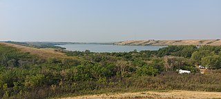
Makwa Lake, which is Cree for Loon Lake, is a lake in the west-central region of the Canadian province of Saskatchewan in the transition zone between parkland and boreal forest. The Battle of Loon Lake, which was last battle of the North-West Rebellion, happened at Steele Narrows, a strait at the entrance to Sanderson Bay on Makwa Lake. The site is now part of Steele Narrows Provincial Park.
Jumbo Lake is a lake in the Canadian province of Saskatchewan in the transition zone between parkland and boreal forest. It is also known as Big Jumbo Lake to differentiate it from adjoining Little Jumbo Lake. Big and Little Jumbo Lakes make up the heart of Makwa Lake Provincial Park and are part of several inter-connected lakes that include Makwa Lake and Upper Makwa Lake. The southern half of the lake is within Makwa Lake Provincial Park and the northern half is within Makwa Lake 129B Indian reserve. Access to both lakes is from Highway 699.
Makwa Lake Provincial Park is a recreational provincial park in the west-central region of the Canadian province of Saskatchewan in the transition zone between parkland and boreal forest. The park was established in 1986 and is centred around the lakes of Big Jumbo, Little Jumbo, and Makwa. Prior to its establishment, the park was a provincial recreation site. The main entrance to Makwa Lake Park is at the south-east corner of Makwa Lake about 3 kilometres (1.9 mi) west of the village of Loon Lake. Access is from Highway 699.
Steele Narrows Provincial Park is an historical provincial park in the west-central region of the Canadian province of Saskatchewan in the transition zone between parkland and boreal forest. It is located on Makwa Lake at Steele Narrows – the channel that separates Sanderson Bay from Makwa Lake – about 10 kilometres (6.2 mi) west of the village of Loon Lake along Highway 699. The park is the site of the Battle of Loon Lake, which was not only the last battle of the North-West Rebellion, but also the last battle fought on Canadian soil. The battle occurred on 3 June 1885.


