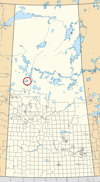
Canoe Lake 165 is an Indian reserve of the Canoe Lake Cree First Nation in the boreal forest of northern Saskatchewan, Canada. Its location is on Canoe Lake approximately thirty miles west of Beauval, within the ancient hunting grounds of the Woodland Cree. In the 2016 Canadian Census, it recorded a population of 912 living in 250 of its 273 total private dwellings. In the same year, its Community Well-Being index was calculated at 53 of 100, compared to 58.4 for the average First Nations community and 77.5 for the average non-Indigenous community. The reserve includes the settlement of Canoe Narrows. The name of the reserve and the settlement in Cree is nêhiyaw-wapâsihk ᓀᐦᐃᔭᐤ ᐘᐹᓯᕽ.

Waterhen 130 is an Indian reserve of the Waterhen Lake First Nation in Saskatchewan. It is 39 kilometers north of Meadow Lake. In the 2016 Canadian Census, it recorded a population of 672 living in 196 of its 213 total private dwellings. In the same year, its Community Well-Being index was calculated at 51 of 100, compared to 58.4 for the average First Nations community and 77.5 for the average non-Indigenous community.

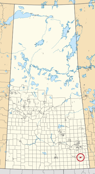
Assiniboine 76 is an Indian reserve of the Carry the Kettle Nakoda First Nation in Saskatchewan. It is 80 kilometers east of Regina. In the 2016 Canadian Census, it recorded a population of 443 living in 182 of its 214 total private dwellings. In the same year, its Community Well-Being index was calculated at 54 of 100, compared to 58.4 for the average First Nations community and 77.5 for the average non-Indigenous community.
Big Island Lake Cree Territory is an Indian reserve of the Big Island Lake Cree Nation in Saskatchewan. It is 39 kilometres east of Cold Lake, Alberta. In the 2016 Canadian Census, it recorded a population of 808 living in 132 of its 165 total private dwellings. In the same year, its Community Well-Being index was calculated at 37 of 100, compared to 58.4 for the average First Nations community and 77.5 for the average non-Indigenous community.

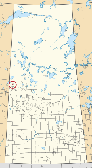
Buffalo River Dene Nation 193 is an Indian reserve of the Buffalo River Dene Nation in Saskatchewan. It is 84 kilometres northwest of Île-à-la-Crosse. In the 2016 Canadian Census, it recorded a population of 783 living in 233 of its 260 total private dwellings. In the same year, its Community Well-Being index was calculated at 54 of 100, compared to 58.4 for the average First Nations community and 77.5 for the average non-Indigenous community.

Chicken 224 is an Indian reserve of the Black Lake Denesuline First Nation in Saskatchewan. It is 170 kilometres southeast of Uranium City. In the 2016 Canadian Census, it recorded a population of 1379 living in 263 of its 280 total private dwellings. In the same year, its Community Well-Being index was calculated at 42 of 100, compared to 58.4 for the average First Nations community and 77.5 for the average non-Indigenous community.

Fishing Lake 89 is an Indian reserve of the Fishing Lake First Nation in Saskatchewan. It is 119 kilometres (74 mi) north of Fort Qu'Appelle. In the 2016 Canadian Census, it recorded a population of 406 living in 128 of its 161 total private dwellings. In the same year, its Community Well-Being index was calculated at 54 of 100, compared to 58.4 for the average First Nations community and 77.5 for the average non-Indigenous community.

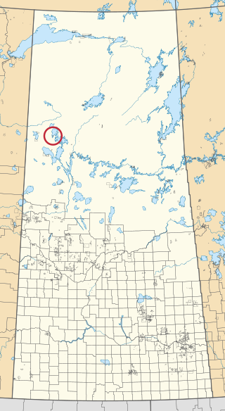
Chitek Lake 191 is an Indian reserve of the Pelican Lake First Nation in the Canadian province of Saskatchewan. It is located on the southern shore of Chitek Lake about 68 kilometres (42 mi) south-east of Meadow Lake. In the 2016 Canadian Census, it recorded a population of 821 living in 164 of its 300 total private dwellings. In the same year, its Community Well-Being index was calculated at 46 of 100, compared to 58.4 for the average First Nations community and 77.5 for the average non-Indigenous community.

Day Star 87 is an Indian reserve of the Day Star First Nation in Saskatchewan. It is 87 kilometres (54 mi) north-west of Fort Qu'Appelle. In the 2016 Canadian Census, it recorded a population of 148 living in 42 of its 62 total private dwellings. In the same year, its Community Well-Being index was calculated at 65 of 100, compared to 58.4 for the average First Nations community and 77.5 for the average non-Indigenous community.

Flying Dust 105 is an Indian reserve of the Flying Dust First Nation in Saskatchewan. It is less than a kilometre northwest of Meadow Lake. In the 2016 Canadian Census, it recorded a population of 577 living in 169 of its 187 total private dwellings. In the same year, its Community Well-Being index was calculated at 63 of 100, compared to 58.4 for the average First Nations community and 77.5 for the average non-Indigenous community.

Makwa Lake 129B is an Indian reserve of the Makwa Sahgaiehcan First Nation in Saskatchewan. It is 95 miles northwest of North Battleford. In the 2016 Canadian Census, it recorded a population of 982 living in 226 of its 444 total private dwellings. In the same year, its Community Well-Being index was calculated at 47 of 100, compared to 58.4 for the average First Nations community and 77.5 for the average non-Indigenous community.

Ministikwan 161 is an Indian reserve of the Ministikwan Lake Cree Nation in Saskatchewan. It is 161 kilometres northwest of North Battleford. In the 2016 Canadian Census, it recorded a population of 624 living in 128 of its 150 total private dwellings. In the same year, its Community Well-Being index was calculated at 38 of 100, compared to 58.4 for the average First Nations community and 77.5 for the average non-Indigenous community.

Ministikwan 161A is an Indian reserve of the Ministikwan Lake Cree Nation in Saskatchewan. It is 177 kilometres northwest of North Battleford. In the 2016 Canadian Census, it recorded a population of 223 living in 40 of its 42 total private dwellings. In the same year, its Community Well-Being index was calculated at 35 of 100, compared to 58.4 for the average First Nations community and 77.5 for the average non-Indigenous community.
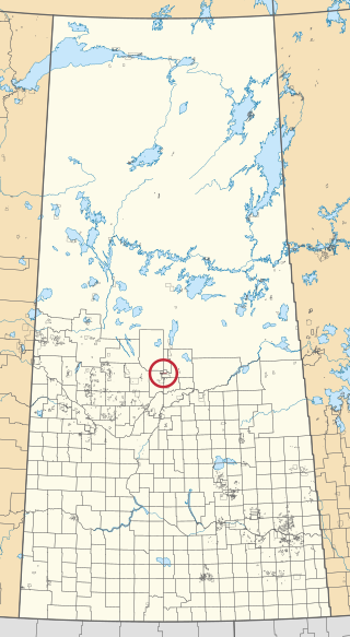
Montreal Lake 106B is an Indian reserve of the Montreal Lake Cree Nation in Saskatchewan. It is adjacent to Little Red River 106C and 39 kilometres (24 mi) north of Prince Albert. In the 2016 Canadian Census, it recorded a population of 442 living in 113 of its 118 total private dwellings. In the same year, its Community Well-Being index was calculated at 47 of 100, compared to 58.4 for the average First Nations community and 77.5 for the average non-Indigenous community.

Moosomin 112B is an Indian reserve of the Moosomin First Nation in Saskatchewan. It is 32 kilometres north of North Battleford. In the 2016 Canadian Census, it recorded a population of 724 living in 183 of its 195 total private dwellings. In the same year, its Community Well-Being index was calculated at 48 of 100, compared to 58.4 for the average First Nations community and 77.5 for the average non-Indigenous community.

Muscowpetung 80 is an Indian reserve of the Muscowpetung First Nation in Saskatchewan. It is 31 kilometres west of Fort Qu'Appelle along the south-west shore of Pasqua Lake, which is one of four Fishing Lakes. In the 2016 Canadian Census, it recorded a population of 275 living in 87 of its 112 total private dwellings. In the same year, its Community Well-Being index was calculated at 54 of 100, compared to 58.4 for the average First Nations community and 77.5 for the average non-Indigenous community.

Pasqua 79 is an Indian reserve of the Pasqua First Nation in Saskatchewan. It is 16 kilometres west of Fort Qu'Appelle. In the 2016 Canadian Census, it recorded a population of 517 living in 173 of its 200 total private dwellings. In the same year, its Community Well-Being index was calculated at 56 of 100, compared to 58.4 for the average First Nations community and 77.5 for the average non-Indigenous community.

Standing Buffalo 78 is an Indian reserve of the Standing Buffalo Dakota Nation in Saskatchewan. It is 8 kilometres north-west of Fort Qu'Appelle. In the 2016 Canadian Census, it recorded a population of 569 living in 184 of its 198 total private dwellings. In the same year, its Community Well-Being index was calculated at 59 of 100, compared to 58.4 for the average First Nations community and 77.5 for the average non-Indigenous community.
Turnor Lake 193B is an Indian reserve of the Birch Narrows Dene Nation in Saskatchewan. It is 124 kilometres northwest of Île-à-la-Crosse. In the 2016 Canadian Census, it recorded a population of 476 living in 131 of its 146 total private dwellings. In the same year, its Community Well-Being index was calculated at 58 of 100, compared to 58.4 for the average First Nations community and 77.5 for the average non-Indigenous community.
White Bear 70 is an Indian reserve of the White Bear First Nations in Saskatchewan. It is 13 kilometres north of Carlyle and encompasses a total of 12,038.4 hectares. In the 2016 Canadian Census, it recorded a population of 691 living in 237 of its 972 total private dwellings. In the same year, its Community Well-Being index was calculated at 60 of 100, compared to 58.4 for the average First Nations community and 77.5 for the average non-Indigenous community.

