Goodsoil

Last updated • 2 min readFrom Wikipedia, The Free Encyclopedia

Goodsoil
Village of Goodsoil
Canada Saskatchewan location map.svg
Red pog.svg
Goodsoil
Location of Goodsoil in Saskatchewan
Canada location map 2.svg
Red pog.svg
Goodsoil
Goodsoil (Canada)
Coordinates: 54°23′56″N109°14′17″W / 54.399°N 109.238°W / 54.399; -109.238
Country Flag of Canada (Pantone).svg  Canada
Province Flag of Saskatchewan.svg  Saskatchewan
Region West-central
Census division 17
Rural Municipality Beaver River No. 622
Post office FoundedDecember 1, 1929
Government
  Type Municipal
  Governing body Goodsoil Village Council
   Mayor John Purves
   Administrator Vanessa Weber
Area
  Total1.98 km2 (0.76 sq mi)
Population
 (2016)
  Total282
  Density142.6/km2 (369/sq mi)
Time zone UTC-6 (CST)
Postal code
S0M 1A0
Area code 306
Highways Saskatchewan Highway 26 (jct).svg Highway 26
Railways None
Website Village of Goodsoil
[1] [2] [3] [4]

Goodsoil (2016 population: 282) is a village in the Canadian province of Saskatchewan within the Rural Municipality of Beaver River No. 622 and Census Division No. 17. The Goodsoil Historical Museum Site (c. 193245) is a municipal heritage property on the Canadian Register of Historic Places. [5] It is the western gateway to Meadow Lake Provincial Park.

Contents

Parks and recreation

Goodsoil is located about one kilometre south of Meadow Lake Provincial Park's boundary, which is Saskatchewan's largest provincial park. The park has over 25 lakes and features recreational activities including boating, camping, fishing, and swimming. [6]

Eight kilometres west of Goodsoil is Northern Meadows Golf Club, an 18-hole championship course that includes a proshop with rentals and a driving range. [7] The golf course is located on the northern shore of Bousquet Lake along Highway 954.

History

Goodsoil incorporated as a village on January 1, 1960. [8]

Transportation

Goodsoil is located along Highway 26 about five kilometres north of Highway 55. At the north end of town, Highway 26 turns into Highway 224 and continues on into Meadow Lake Provincial Park. Highway 954 begins at the north end of town at the junction with Highway 26 / 224 and heads west into Meadow Lake Provincial Park.

Goodsoil Airport is located 1 nautical mile (1.9 km; 1.2 mi) north north-west of the village along Highway 954. [9]

Demographics

Population history
(1981–2016)
YearPop.±%
1981263    
1986269+2.3%
1991288+7.1%
1996 278−3.5%
2001 284+2.2%
2006 253−10.9%
2011 281+11.1%
2016 282+0.4%
Source: Statistics Canada via Saskatchewan Bureau of Statistics [10] [11]

In the 2021 Census of Population conducted by Statistics Canada, Goodsoil had a population of 301 living in 128 of its 143 total private dwellings, a change of

In the 2016 Census of Population, the Village of Goodsoil recorded a population of 282 living in 122 of its 156 total private dwellings, a

Notable people

See also

Related Research Articles

<span class="mw-page-title-main">Loon Lake, Saskatchewan</span> Village in Saskatchewan, Canada

Loon Lake is a village in the Canadian province of Saskatchewan within the Rural Municipality of Loon Lake No. 561 and Census Division No. 17. The Makwa Sahgaiehcan First Nation reserve is to the east of the village. The village is located on Highway 26 north-east of the city of Lloydminster.

Goodsoil Airport is located 1 nautical mile north-northwest of the village of Goodsoil, Saskatchewan, Canada, just south of Meadow Lake Provincial Park. It is on Highway 954, near the junction with Highways 26 and 224.

<span class="mw-page-title-main">Regina Beach</span> Town in Saskatchewan, Canada

Regina Beach is a town in south central Saskatchewan, located on Highway 54, close to where Highway 11 intersects with the Qu'Appelle Valley.

Highway 954 is a provincial highway in the Canadian province of Saskatchewan. It runs from Highway 26 on the north side of Goodsoil to a dead end at Northern Cross Resort on Lac des Îles within Meadow Lake Provincial Park. At the eastern end of the highway is the Goodsoil Airport. It is about 12.9 kilometres (8.0 mi) long.

<span class="mw-page-title-main">Rural Municipality of Senlac No. 411</span> Rural municipality in Saskatchewan, Canada

The Rural Municipality of Senlac No. 411 is a rural municipality (RM) in the Canadian province of Saskatchewan within Census Division No. 13 and SARM Division No. 6. Located in the west-central portion of the province, it is adjacent to the Alberta boundary.

<span class="mw-page-title-main">Rural Municipality of Arborfield No. 456</span> Rural municipality in Saskatchewan, Canada

The Rural Municipality of Arborfield No. 456 is a rural municipality (RM) in the Canadian province of Saskatchewan within Census Division No. 14 and SARM Division No. 4.

<span class="mw-page-title-main">Rural Municipality of Meadow Lake No. 588</span> Rural municipality in Saskatchewan, Canada

The Rural Municipality of Meadow Lake No. 588 is a rural municipality (RM) in the Canadian province of Saskatchewan within Census Division No. 17 and SARM Division No. 6.

Shell Lake is a village in the Canadian province of Saskatchewan within the Rural Municipality of Spiritwood No. 496 and Census Division No. 16. This village is 90 kilometres west of the City of Prince Albert. It was formerly part of the Rural Municipality (RM) of Shell Lake No. 495 before it was absorbed by the RM of Spiritwood No. 496. It is the administrative centre of the Ahtahkakoop Cree First Nation band government.

<span class="mw-page-title-main">Frontier, Saskatchewan</span> Village in Saskatchewan, Canada

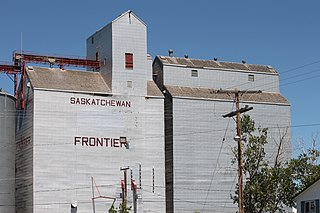
Frontier is a village in the Canadian province of Saskatchewan within the Rural Municipality of Frontier No. 19 and Census Division No. 4. Frontier is on Highway 18 and is served by the Frontier Airport located (3.7 km) south of the village.

Dorintosh is a village in the Canadian province of Saskatchewan within the Rural Municipality of Meadow Lake No. 588 and Census Division No. 17.

Glaslyn is a village in the Canadian province of Saskatchewan within the Rural Municipality of Parkdale No. 498 and Census Division No. 17. The village is located 67 km north of the City of North Battleford and 91 km south of Meadow Lake at the intersection of Highway 4 and Highway 3.

<span class="mw-page-title-main">Marsden, Saskatchewan</span> Village in Saskatchewan, Canada

Marsden is a village in the Canadian province of Saskatchewan within the Rural Municipality of Manitou Lake No. 442 and Census Division No. 13. It gained notoriety shortly after the impact of the Buzzard Coulee meteorite near the village on 20 November 2008.

<span class="mw-page-title-main">Meota</span> Village in Saskatchewan, Canada

Meota is a village in the Canadian province of Saskatchewan within the Rural Municipality of Meota No. 468 and Census Division No. 17. The village name is derived from the Cree phrase Meotate or Mo-Was-In-Ota, meaning "good place to camp" or "it is good here."

Greig Lake is a resort village in the Canadian province of Saskatchewan within Census Division No. 17. It is on the eastern shore of Greig Lake in the Rural Municipality of Meadow Lake No. 588. The community is surrounded by Meadow Lake Provincial Park.

Mistusinne is a resort village in the Canadian province of Saskatchewan within Census Division No. 7. It is on the shores of Gordon McKenzie Arm of Lake Diefenbaker in the Rural Municipality of Maple Bush No. 224.

<span class="mw-page-title-main">Shields, Saskatchewan</span> Resort village in Saskatchewan, Canada

Shields is a resort village in the Canadian province of Saskatchewan within Census Division No. 11. It is on the shores of Blackstrap Lake in the Rural Municipality of Dundurn No. 314. It east of the town of Dundurn.

<span class="mw-page-title-main">Thode, Saskatchewan</span> Village in Saskatchewan, Canada

Thode is a resort village in the Canadian province of Saskatchewan within Census Division No. 11. It is on the shores of Blackstrap Lake in the Rural Municipality of Dundurn No. 314. It is east of the town of Dundurn.

<span class="mw-page-title-main">Rural Municipality of Duck Lake No. 463</span> Rural municipality in Saskatchewan, Canada

The Rural Municipality of Duck Lake No. 463 is a rural municipality (RM) in the Canadian province of Saskatchewan within Census Division No. 15 and SARM Division No. 5.

<span class="mw-page-title-main">Rural Municipality of Loon Lake No. 561</span> Rural municipality in Saskatchewan, Canada

The Rural Municipality of Loon Lake No. 561 is a rural municipality (RM) in the Canadian province of Saskatchewan within Census Division No. 17 and SARM Division No. 6.

<span class="mw-page-title-main">Rural Municipality of Nipawin No. 487</span> Rural municipality in Saskatchewan, Canada

The Rural Municipality of Nipawin No. 487 is a rural municipality (RM) in the Canadian province of Saskatchewan within Census Division No. 14 and SARM Division No. 4.

References

  1. National Archives, Archivia Net. "Post Offices and Postmasters". Archived from the original on 6 October 2006. Retrieved 2 September 2014.
  2. Government of Saskatchewan, MRD Home. "Municipal Directory System". Archived from the original on 15 January 2016. Retrieved 2 September 2014.
  3. Canadian Textiles Institute. (2005), CTI Determine your provincial constituency, archived from the original on 11 September 2007
  4. Commissioner of Canada Elections, Chief Electoral Officer of Canada (2005), Elections Canada On-line, archived from the original on 21 April 2007
  5. http://www.historicplaces.ca/visit-visite/affichage-display.aspx?id=6999 Canadian Register of Historic Places.
  6. "Meadow Lake Provincial Park". Tourism Saskatchewan. Retrieved 2 January 2022.
  7. "Welcome To Northern Meadows Golf Club". Northern Meadows. Northern Meadows Golf Club. Retrieved 18 June 2023.
  8. "Urban Municipality Incorporations". Saskatchewan Ministry of Government Relations. Archived from the original on 15 October 2014. Retrieved 1 June 2020.
  9. Canada Flight Supplement. Effective 0901 Z 16 July 2020 to 0901Z 10 September 2020.
  10. "Saskatchewan Census Population" (PDF). Saskatchewan Bureau of Statistics. Archived from the original (PDF) on 24 September 2015. Retrieved 31 May 2020.
  11. "Saskatchewan Census Population". Saskatchewan Bureau of Statistics. Retrieved 31 May 2020.
  12. "Population and dwelling counts: Canada, provinces and territories, census divisions and census subdivisions (municipalities), Saskatchewan". Statistics Canada. 9 February 2022. Retrieved 1 April 2022.
  13. "Population and dwelling counts, for Canada, provinces and territories, and census subdivisions (municipalities), 2016 and 2011 censuses – 100% data (Saskatchewan)". Statistics Canada. 8 February 2017. Retrieved 30 May 2020.