In 1905, the Grand Trunk Pacific Railway Company surveyed the area in preparation for a railway line, and the prospect of rail service attracted settlers to the area. The first settlers arrived in 1906, most of whom had shipped their effects to Battleford, the site of the Dominion Lands office in the area. With the nearest source of wood being on the banks of the South Saskatchewan River, approximately 110 kilometres (68mi) away, most of the first homes constructed in the area were sod houses, either frame structures covered with sods, or else built entirely out of sods. These structures generally collapsed after a few years; however one sod house built by English immigrant James Addison, between 1909 and 1911, has been occupied continuously from its construction to the present.
The site for the Hamlet of Coleville was purchased from Charles Farris, and built on his purchased homestead NE 6-32-23-W3. In 1913, Charles Cole submitted names to the railway, and Coleville was chosen for the station and townsite.
Coleville incorporated as a village on July 1, 1953.[6]
Railway
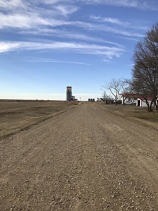
The grade was built for the Biggar–Loverna line of the Grand Trunk Pacific Railway in 1912, and steel was laid in 1913. The construction of the rail site in Coleville began in 1913 with the construction of the railway station and coal box. Jack Binks, section foreman, was the station's first occupant, and George Barrett was the first station agent. After the construction of the station, a water well was required for the steam engines. In 1914 a two-pen, four-car stock yard and hog chute were built, and an 18 metre (60foot) well was dug by hand. A pump house was built, and the Coleville water tower, which is still in use today, was erected. The first pumpman was Mike Crown. The Bigger–Loverna line became part of the Canadian National Railway in 1923. The section toolhouse was built in 1926, and in 1953 a two-car loading platform was built, and an electric pump was installed in the pumphouse.
The station was closed in 1979, and the tracks were torn up in 1998.
Elevators
Soon after the arrival of the railroad in 1913, a grain elevator was built by the Scottish Co-op. Bill Donald was its first agent. This original elevator was replaced in 1940 by a new elevator with a storage capacity of 45,000 imperial bushels (1,600m3). The Alberta Pacific elevator was built in 1917, with Joe Barrows as its first agent. The elevator had a capacity of 23,000 imperial bushels (840m3). It was bought out by Federal Grain in 1943.
The Saskatchewan Wheat Pool was formed in 1924, and built an elevator in Coleville in 1925, now called Pool A.[7] Alf Beal was the first operator. Pool A had a storage capacity of 30,000 imperial bushels (1,100m3). In the late 1970s Pool A was sold and torn down. The Scottish Co-op elevator was purchased in 1948 by the Saskatchewan Wheat Pool and became Pool B. The Federal Grain elevator was acquired by the Pool in 1972, and became Pool C. Pool C was torn down in 1998.
Coleville Post Office
One of the first settlers was Malcolm Cole, who came with his father in 1906, and set up a post office and general store on his homestead shortly thereafter, in the summer of 1907. He named the post office Coleville, derived from his own last name, and the suffix -ville. His brother, Charles Cole, who arrived in 1907, was the postmaster from 1908 until 1917. Around 1914 the post office was moved from the Cole homestead to the townsite of Coleville. When John Brent turned the post office over to H. L. Dumouchel, the post office was moved to the Dumouchel store.
Before railway service to the area, mail was carried in from Battleford. After the Grand Trunk Pacific Railway was built, the mail was carried from Scott by R. A. Cummings of Kerrobert.
Cork obliterators (used to cancel stamps) in the second half of the 20th century are comparatively rare; however, cork obliterators created by H.L. Dumouchel (acting postmaster from 1928 until 1950) were still in use until they were lost in a post office remodelling sometime after 1951.
Coleville Rural Telephone Co.
The Coleville Rural Telephone Co. came into being on Friday, January 28, 1916, following a meeting of a group of ratepayers in Dumouchel's Drug Store. Shortly thereafter a charter was granted by the Department of Telephones and the company was started by issuing a debenture. On February 5, 1917, a tender of $11,298.40 by Heise, O'Bready and Small of Elstow was accepted for the construction of the system. The switchboard was located in the store of A. G. Bridger, who was also publisher of the district news sheet. Bridger resigned in 1919, and George Manning became secretary-treasurer and operator. His salary was $40 a month plus long distance commissions. In 1921 this increased to $60 a month. The linesman was Ed Hogarth, who was paid 50¢ an hour plus 10¢ for mileage.
Subscribers paid an annual rental, which covered switching fees and operator costs. Landowners paid a tax levy on phone lines running through their property, which covered repairing and building lines. The levy was based on the quarters of land through which telephone lines ran. There were two rates. A quarter of land which had a line passing through it paid a 'straight' rate, and a quarter of land in which someone lived and had a phone paid a higher 'take-off' rate. Since the 'straight' rate levy was charged regardless of whether the owner had phone service, land owners without phones could be paying as much or more as land owners with phone service. In spite of attempts to reform this system, it remained in place until the government took over the service. In addition to the annual rental and line levy, there was a special levy to pay back the debenture.
Financing for the company was always difficult, as the large rural population meant the construction and maintenance of many miles of poles and wire for each rural subscriber. In the early years, subscribers who could not pay rentals had their phone removed at their expense; however, by the time of the depression in the 1930s, this was no longer practical or desirable. Instead, subscribers were able to pay off their debt by assisting in the erection of new lines and the maintenance of old ones. Because of the difficulties associated with providing rural telephone service, it was resolved by the Rural Telephone Company as early as 1930 that they ask the provincial government to take over telephone operation for the entire province. While the government did finally take over telephone service, this did not occur until the late 1970s.
Early on, use of the phones and the company's equipment was strictly regulated. There was a three-minute time limit for conversations. Those who did not have a phone were asked to pay 75¢ for using their neighbour's. Farmers and housewives faced fines or prosecution for the use of telephone poles as hitching posts, or incorporating them into their barbed wire fences or clotheslines.
In 1935 George Manning died, and his wife carried on in his capacity until October 1, 1937, when Pat O'Bready, along with his wife Irene, took over as operator, linesman, and troubleman. They were paid $800 per year plus commissions, though this salary was on paper only. In 1940 the company began to emerge from the depression and gain solid financial footing, and in February 1942 the debenture debt was retired.
In 1950, a wind storm on April 15 damaged or destroyed nearly the entire telephone system, which took six months to repair.
In March 1954, Saskatchewan Government Telephones bought the Coleville Telephone plant for $2,301 while the Rural Company remained agent for the town. A new switchboard was installed, and private lines were made available. In 1956 black wall or desk cradle phones arrived, and the old box-crank phones were reclaimed. On July 1, 1957, Pat O'Bready resigned as linesman and operator, although he retained the post of troubleman. Six months later the Rural Company resigned as agent for the Government Telephones.
By the 1960s, 24-hour service was being provided. Previously official hours had been from 8 a.m. until 9 or 10 p.m. (depending on season) on weekdays and Saturday, and from 10 a.m. until 2 p.m. on Sundays, although there was always someone available for emergencies. In 1965 the automatic dial system was completed, and calls were no longer routed through the operator. In 1967 the Coleville Rural Teleqhone Co. Ltd. was sold to the Kindersley Rural Telephone Co. Ltd. for $1, and Coleville was allowed one member to sit on the Kindersley board. In 1977 the government took over the Kindersley Rural Telephone Co.
In the 2021 Census of Population conducted by Statistics Canada, Coleville had a population of 280 living in 129 of its 155 total private dwellings, a change of -8.2% from its 2016 population of 305. With a land area of 1.66km2 (0.64sqmi), it had a population density of 168.7/km2 (436.9/sqmi) in 2021.[1]
In the 2016 Census of Population, the Village of Coleville recorded a population of 305 living in 137 of its 163 total private dwellings, a -2% change from its 2011 population of 311. With a land area of 1.87km2 (0.72sqmi), it had a population density of 163.1/km2 (422.4/sqmi) in 2016.[11]
Attractions
Amenities in the community include a library, a skating rink and a two-sheet curling rink. At nearby Laing's Park, also referred to as the three-mile park in reference to its distance from village, are several ball diamonds and a nine-hole golf course. The golf course once featured a pumpjack hazard.
Education
Coleville is located within the Sun West School Division. Children attend the Rossville School located within the community for kindergarten through grade 7. For grades 8–12, students are bused to Kindersley Composite School, located approximately twenty minutes away in Kindersley.
The Warwick School was a one-room schoolhouse for the area that was closed in 1940. It was moved to Main Street in Coleville in 1946 where it served as the RM's office. When the RM moved to a new building in the 1980s, it continued to serve the community, first as the local Scout and Brownie hall, and now as a playschool.
Notable people
Jeni Mayer, author of such children's books as The Mystery of the Turtle Lake Monster and Suspicion Island, was born and raised in Coleville. Canadian artist, Jean A. Humphrey lived in Coleville for over 50 years.
Sintaluta is a town in Saskatchewan, Canada. The population of Sintaluta is 124 people according to the 2021 Census of Population. The town is located about 85 km east of Regina. The town is on the north side of the Trans-Canada Highway.
Lafleche is a small town in southwest Saskatchewan, Canada in the Rural Municipality of Wood River No. 74. The community is located at the intersection of Highway 13 and Highway 58. It is 20 km south of Gravelbourg and 45 km west of Assiniboia. It is situated on the south bank of Lafleche Creek, which is a tributary of Wood River. Thomson Lake Regional Park is located 10 minutes north of town.
Archerwill is a village in the Canadian province of Saskatchewan within the Rural Municipality of Barrier Valley No. 397 and Census Division No. 14. The village is approximately 55 km (30 mi) north of Wadena, 52 km (30 mi) south of Tisdale and 70 km (40 mi) southeast of the city of Melfort. Since 1981 Archerwill has been the administrative centre of the RM of Barrier Valley.
Rockglen is a town in the Burning Hills of the Wood Mountain Uplands, in Saskatchewan, Canada. It offers various amenities including a school, community hall, public library and five parks, as well a local service industry. The municipal office of the Rural Municipality of Poplar Valley No. 12 lies within the boundaries of Rockglen, and Rockglen businesses are supported primarily by agriculture. In the Burning Hills agriculture consists of dry land farming and cattle. Rockglen is located along Highway 2 south of Assiniboia, Highway 18 west of Coronach, and Highways 2 and 18 north of Port Poplar River. Fife Lake is 9.3 kilometres (5.8 mi) to the east.
Arbuthnot is an unincorporated community located in Glen Bain Rural Municipality No. 105, Saskatchewan, Canada east of Route 19. It was located in census Division No. 2. It was on mile 63 of the Canadian Pacific Railway right of way, southeast of Swift Current and in the NW section 9- township 10- range 7 west of the third meridian.
Love is a village in the Canadian province of Saskatchewan within the Rural Municipality of Torch River No. 488 and Census Division No. 14. The village is northeast of the City of Prince Albert and about 48 km (30 mi) south of Prince Albert National Park boundaries and 16 km (9.9 mi) south of Torch River Provincial Forest.
The Rural Municipality of Oakdale No. 320 is a rural municipality (RM) in the Canadian province of Saskatchewan within Census Division No. 13 and SARM Division No. 6. Located in the west-central portion of the province, it is near the Alberta boundary.
Elrose is a town located just to the north of the Coteau Hills. It is south of Rosetown and north of Swift Current on Highway 4 and Highway 44. A community in the middle of an agricultural economy, Elrose has also become a local hub of activity in the oil industry. The town is surrounded by the Rural Municipality of Monet No. 257.
Kenaston is a village in the Canadian province of Saskatchewan within the Rural Municipality of McCraney No. 282 and Census Division No. 11. Kenaston is located on Highway 11 at the junction of Highway 15 and is also near Highway 19. This is a scenic area of Saskatchewan situated within the rolling Allan Hills. Kenaston is located between Danielson Provincial Park and Blackstrap Provincial Park.
Govenlock is an unincorporated community within the Rural Municipality of Reno No. 51, Saskatchewan, Canada. It previously held the status of a village, with a peak population of 151 residents; its village status was dissolved on January 1, 1976. The former townsite of Govenlock is located on Highway 21 & Highway 13, also known as the historic Red Coat Trail, about 15 km east of the Alberta-Saskatchewan border. Although many cement foundations and wooden sidewalks can still be found scattered around the town site, the only building that still stands as of 2010 is the old community hall and a commemorative plaque in remembrance of Govenlock's rich history.
Marquis is a village in the Canadian province of Saskatchewan within the Rural Municipality of Marquis No. 191 and Census Division No. 7. It is on Highway 42 about 32 km northwest of Moose Jaw.
Frobisher is a village in the Canadian province of Saskatchewan within the Rural Municipality of Coalfields No. 4 and Census Division No. 1. It has an elevation of 576 metres above sea level.
Harris is a village in the Canadian province of Saskatchewan within the Rural Municipality of Harris No. 316 and Census Division No. 12. It was the site of the Great Ruby Hoax in 1914. Harris was named for Richard Elford Harris, an early settler to the area.
Maymont is a village in the Canadian province of Saskatchewan within the Rural Municipality of Mayfield No. 406 and Census Division No. 16. It is 90 kilometres (56 mi) north-west of the city of Saskatoon.
Meota is a village in the Canadian province of Saskatchewan within the Rural Municipality of Meota No. 468 and Census Division No. 17. The village name is derived from the Cree phrase Meotate or Mo-Was-In-Ota, meaning "good place to camp" or "it is good here."
Montmartre is a village in the Canadian province of Saskatchewan within the Rural Municipality of Montmartre No. 126 and Census Division No. 6. It is 91 kilometres (57 mi) east of the city of Regina on Highway 48.
Coleville School District No. 3645 was created to educate students in the area of Coleville, Saskatchewan. The school district operated from 1913 to March 6, 1946, when it became a part of the consolidated Kindersley School Unit.
Smiley is a village in the Canadian province of Saskatchewan within the Rural Municipality of Prairiedale No. 321 and Census Division No. 13. The village is located approximately 20 km northwest of the town of Kindersley at the intersection of Highway 307 and Highway 772. The Grand Trunk Pacific Railway was completed in 1913, bringing an economic boom to the village's early years. On April 26, 1987 the Dodsland subdivision between Dodsland and Smiley was transferred to the Canadian Pacific Railway. Due to the close proximity to major grain centres such as Kindersley, CPR put the line up for abandonment and was granted permission to remove the track by the Canadian Transportation Agency on October 29, 1997.
Wartime is an unincorporated community and former hamlet, within the Rural Municipality of Monet No. 257, Saskatchewan, Canada. The community is located along Highway 44 approximately 13 km west of Elrose along Canadian National Railway's Elrose sub-division track. The community once boasted a train station built in 1914 which was demolished in 1978, two grain elevators; a Saskatchewan Wheat Pool and a Federal elevator as well as a wooden water tank. The elevators have disappeared but the water tower is still standing and in use.
Outram is an unincorporated community in the Rural Municipality of Cambria No. 6, Saskatchewan, Canada. It is located at NE Section 19, Township 2, Range 10, W2, just north of highway 18 between Estevan and Torquay, Saskatchewan along the Long Creek Railroad.
This page is based on this Wikipedia article Text is available under the CC BY-SA 4.0 license; additional terms may apply. Images, videos and audio are available under their respective licenses.