Related Research Articles
Milden is a village in the Canadian province of Saskatchewan within the Rural Municipality of Milden No. 286 and Census Division No. 12. The village is located at the junction of Highway 15 and Highway 655 approximately 20 km west of Outlook on Highway 15.

Edam is a village in the Canadian province of Saskatchewan within the Rural Municipality of Turtle River No. 469 and Census Division No. 17. Edam is located off Highway 26, south of Turtleford and north of Vawn.
Albertville is a village in the Canadian province of Saskatchewan within the Rural Municipality of Wise Creek No. 77 and Census Division No. 15. It is approximately 25 km northeast of the City of Prince Albert.

The Rural Municipality of Shellbrook No. 493 is a rural municipality (RM) in the Canadian province of Saskatchewan within Census Division No. 16 and SARM Division No. 5. It is located in the north-central portion of the province west of the City of Prince Albert.
Aylsham is a village in the Canadian province of Saskatchewan within the Rural Municipality of Nipawin No. 487 and Census Division No. 14. The village is approximately 65 km (40 mi) northeast of the City of Melfort.

The Rural Municipality of Argyle No. 1 is a rural municipality (RM) in the Canadian province of Saskatchewan within Census Division No. 1 and SARM Division No. 1. It is located in the southeast corner of the province along Highway 18.

Belle Plaine is a village in the Canadian province of Saskatchewan within the Rural Municipality of Pense No. 160 and Census Division No. 6. Belle Plaine is located on Highway 1, 21 kilometres east of the City of Moose Jaw in south-central Saskatchewan. Buffalo Pound Provincial Park and Regina Beach are located near Belle Plaine.
Marquis is a village in the Canadian province of Saskatchewan within the Rural Municipality of Marquis No. 191 and Census Division No. 7. It is on Highway 42 about 32 km northwest of Moose Jaw.
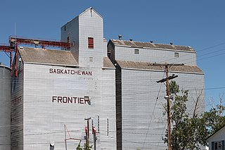
Frontier is a village in the Canadian province of Saskatchewan within the Rural Municipality of Frontier No. 19 and Census Division No. 4. Frontier is on Highway 18 and is served by the Frontier Airport located (3.7 km) south of the village.

Disley is a village in the Canadian province of Saskatchewan within the Rural Municipality of Lumsden No. 189 and Census Division No. 6. It is located 18 km (11 mi) west of Lumsden just south of the Louis Riel Trail and 48 kilometres northwest of the City of Regina.

Invermay is a village in the Canadian province of Saskatchewan within the Rural Municipality of Invermay No. 305 and Census Division No. 9. Invermay is about 50 km west of Canora or about 50 km east of Wadena on Highway 5.
Lucky Lake is a village in the Canadian province of Saskatchewan within the Rural Municipality of Canaan No. 225 and Census Division No. 7. The Village is located at the junction of Highway 42, Highway 45 and Highway 646 approximately 90 km northeast of Swift Current, Saskatchewan.
McLean is a village in the Canadian province of Saskatchewan within the Rural Municipality of South Qu'Appelle No. 157 and Census Division No. 6. It is on Highway between Qu'Appelle and Balgonie. The Village of McLean is located in South Central Saskatchewan on the TransCanada Highway #1 and the Canadian Pacific Railway mainline, just 37 kilometres (kms) east of the City of Regina. The population of McLean is 405.

Meacham is a village in the Canadian province of Saskatchewan within the Rural Municipality of Colonsay No. 342 and Census Division No. 11. It is located 69 kilometres east of the City of Saskatoon on Highway 2.
Meath Park is a village in the Canadian province of Saskatchewan within the Rural Municipality of Garden River No. 490 and Census Division No. 15.
Waseca is a village in the Canadian province of Saskatchewan within the Rural Municipality of Eldon No. 471 and Census Division No. 17. Waseca is located on Highway 16, the Yellowhead Highway, in northwest Saskatchewan. Waseca is located east of Lashburn and west of Maidstone.
St. Benedict is a village in the Canadian province of Saskatchewan within the Rural Municipality of Three Lakes No. 400 and Census Division No. 15. Located in the Carlton Trail Region of the province, it is 56 km (35 mi) north of the City of Humboldt off Highway 20.
Candle Lake is a resort village in the Canadian province of Saskatchewan within Census Division No. 15. It is on the shores of Candle Lake in the Rural Municipality of Paddockwood No. 520.
Weirdale is a village in the Canadian province of Saskatchewan within the Rural Municipality of Garden River No. 490 and Census Division No. 15. Weirdale is about 48 km northeast of the City of Prince Albert along Highway 55.

The Rural Municipality of Paddockwood No. 520 is a rural municipality (RM) in the Canadian province of Saskatchewan within Census Division No. 15 and SARM Division No. 5.
References
- ↑ Government of Saskatchewan (April 11, 2007), Municipal Directory System, archived from the original on March 19, 2005, retrieved 2007-05-05
- ↑ Walker, Jack (1985), Beginnings and Bygones of Old Paddock Wood, Paddock Wood, Kent: J C Walker
- ↑ Paddockwood Historical Society (1982), Cordwood and courage : 1911-1982, Paddockwood, Sask.: Paddockwood & District History Book, ISBN 0-88925-407-9
- ↑ Wapiti Regional Library. An entire world worth exploring., archived from the original on 2006-12-13, retrieved 2007-05-05
- ↑ Helbig's Forest Course, Paddockwood, Saskatchewan - Golf Course, archived from the original on 2007-09-27, retrieved 2007-05-05
- ↑ Government of Canada through the Canadian Apparel & Textile Industries Program (CATIP), POLITICAL CONTACTS, archived from the original on 2007-09-27, retrieved 2007-05-05
- ↑ "Urban Municipality Incorporations". Saskatchewan Ministry of Government Relations. Archived from the original on October 15, 2014. Retrieved June 1, 2020.
- ↑ "Saskatchewan Census Population" (PDF). Saskatchewan Bureau of Statistics. Archived from the original (PDF) on September 24, 2015. Retrieved May 31, 2020.
- ↑ "Saskatchewan Census Population". Saskatchewan Bureau of Statistics. Retrieved May 31, 2020.
- ↑ "Population and dwelling counts: Canada, provinces and territories, census divisions and census subdivisions (municipalities), Saskatchewan". Statistics Canada. February 9, 2022. Retrieved April 1, 2022.
- ↑ "Population and dwelling counts, for Canada, provinces and territories, and census subdivisions (municipalities), 2016 and 2011 censuses – 100% data (Saskatchewan)". Statistics Canada. February 8, 2017. Retrieved May 30, 2020.
| North: Northern Provincial Forest Forest Gate | Rebitt Lake McConechy Lake | Montreal | ||
| West: Northside | Christopher Lake Emma Lake | Paddockwood | East: Meath Park | Weirdale Foxford |
| South: Albertville | Henribourg |

| General | |
|---|---|
| National libraries | |