Ahtahkakoop 104 is an Indian reserve of the Ahtahkakoop Cree Nation in Saskatchewan. It is 72 kilometers northwest of Prince Albert. In the 2016 Canadian Census, it recorded a population of 1472 living in 386 of its 424 total private dwellings. In the same year, its Community Well-Being index was calculated at 46 of 100, compared to 58.4 for the average First Nations community and 77.5 for the average non-Indigenous community.

Seekaskootch 119 is an Indian reserve of the Onion Lake Cree Nation in Saskatchewan. It is 142 kilometres northwest of North Battleford. In the 2016 Canadian Census, it recorded a population of 2574 living in 578 of its 639 total private dwellings. In the same year, its Community Well-Being index was calculated at 53 of 100, compared to 58.4 for the average First Nations community and 77.5 for the average non-Indigenous community.

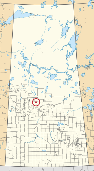
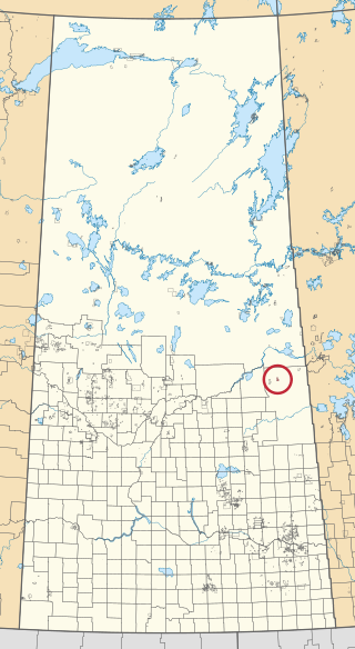
James Smith 100 is an Indian reserve of the James Smith Cree Nation in Saskatchewan. It is 58 kilometers east of Prince Albert. In the 2016 Canadian Census, it recorded a population of 743 living in 152 of its 152 total private dwellings. In the same year, its Community Well-Being index was calculated at 46 of 100, compared to 58.4 for the average First Nations community and 77.5 for the average non-Indigenous community.
Big River 118 is an Indian reserve of the Big River First Nation in Saskatchewan. It is 98 kilometres northwest of Prince Albert. In the 2016 Canadian Census, it recorded a population of 1553 living in 366 of its 407 total private dwellings. In the same year, its Community Well-Being index was calculated at 46 of 100, compared to 58.4 for the average First Nations community and 77.5 for the average non-Indigenous community.

Chicken 224 is an Indian reserve of the Black Lake Denesuline First Nation in Saskatchewan. It is 170 kilometres southeast of Uranium City. In the 2016 Canadian Census, it recorded a population of 1379 living in 263 of its 280 total private dwellings. In the same year, its Community Well-Being index was calculated at 42 of 100, compared to 58.4 for the average First Nations community and 77.5 for the average non-Indigenous community.
Cumberland 100A is an Indian reserve of the James Smith Cree Nation in Saskatchewan. It is 61 kilometres southeast of Prince Albert. The 2016 Canadian Census, recorded a population of 317 living in 79 of its 82 total private dwellings. In the same year, its Community Well-Being index was calculated at 50 of 100, compared to 58.4 for the average First Nations community and 77.5 for the average non-Indigenous community.

Cumberland House Cree Nation 20 is an Indian reserve of the Cumberland House Cree Nation in Saskatchewan. The reserve is on Cumberland Island in the Saskatchewan River Delta, about 96 kilometres (60 mi) south-west of Flin Flon.

Flying Dust 105 is an Indian reserve of the Flying Dust First Nation in Saskatchewan. It is less than a kilometre northwest of Meadow Lake. In the 2016 Canadian Census, it recorded a population of 577 living in 169 of its 187 total private dwellings. In the same year, its Community Well-Being index was calculated at 63 of 100, compared to 58.4 for the average First Nations community and 77.5 for the average non-Indigenous community.

Lac la Ronge 156 is an Indian reserve of the Lac La Ronge Indian Band in Saskatchewan. It is 10 kilometres southwest of Lac la Ronge. In the 2016 Canadian Census, it recorded a population of 2017 living in 441 of its 480 total private dwellings. In the same year, its Community Well-Being index was calculated at 50 of 100, compared to 58.4 for the average First Nations community and 77.5 for the average non-Indigenous community.

Little Red River 106C is an Indian reserve of the Lac La Ronge Indian Band in Saskatchewan. It is 34 kilometres north of Prince Albert. In the 2016 Canadian Census, it recorded a population of 354 living in 88 of its 98 total private dwellings. In the same year, its Community Well-Being index was calculated at 48 of 100, compared to 58.4 for the average First Nations community and 77.5 for the average non-Indigenous community.

Moosomin 112B is an Indian reserve of the Moosomin First Nation in Saskatchewan. It is 32 kilometres north of North Battleford. In the 2016 Canadian Census, it recorded a population of 724 living in 183 of its 195 total private dwellings. In the same year, its Community Well-Being index was calculated at 48 of 100, compared to 58.4 for the average First Nations community and 77.5 for the average non-Indigenous community.

Morin Lake 217 is an Indian reserve of the Lac La Ronge Indian Band in Saskatchewan. It is 24 kilometres east of Lac la Ronge. In the 2016 Canadian Census, it recorded a population of 577 living in 135 of its 155 total private dwellings. In the same year, its Community Well-Being index was calculated at 45 of 100, compared to 58.4 for the average First Nations community and 77.5 for the average non-Indigenous community.
The Muskoday Reserve is an Indian reserve of the Muskoday First Nation in Saskatchewan. It is 19 kilometres southeast of Prince Albert. In the 2016 Canadian Census, it recorded a population of 647 living in 205 of its 217 total private dwellings. In the same year, its Community Well-Being index was calculated at 64 of 100, compared to 58.4 for the average First Nations community and 77.5 for the average non-Indigenous community.

Saulteaux 159 is an Indian reserve of the Saulteaux First Nation in Saskatchewan. It is 43 kilometres north of North Battleford. In the 2016 Canadian Census, it recorded a population of 473 living in 133 of its 142 total private dwellings. In the same year, its Community Well-Being index was calculated at 50 of 100, compared to 58.4 for the average First Nations community and 77.5 for the average non-Indigenous community.
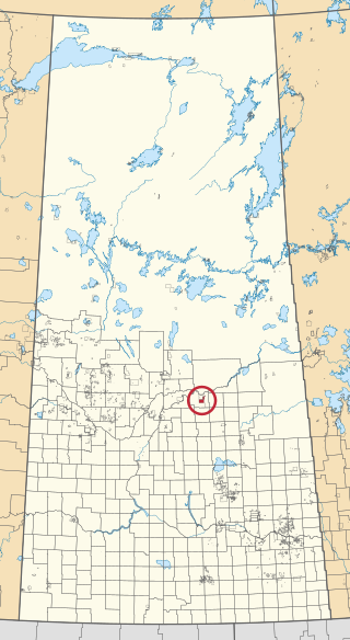
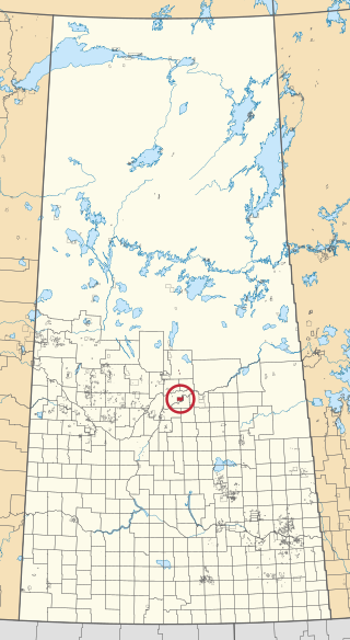
Shoal Lake 28A is an Indian reserve of the Shoal Lake Cree Nation in Saskatchewan. It is 92 kilometres east of Nipawin. In the 2016 Canadian Census, it recorded a population of 424 living in 115 of its 118 total private dwellings. In the same year, its Community Well-Being index was calculated at 46 of 100, compared to 58.4 for the average First Nations community and 77.5 for the average non-Indigenous community.

Southend 200 is an Indian reserve of the Peter Ballantyne Cree Nation in Saskatchewan. It is 402 kilometres northeast of Prince Albert. In the 2016 Canadian Census, it recorded a population of 917 living in 177 of its 206 total private dwellings. In the same year, its Community Well-Being index was calculated at 43 of 100, compared to 58.4 for the average First Nations community and 77.5 for the average non-Indigenous community.

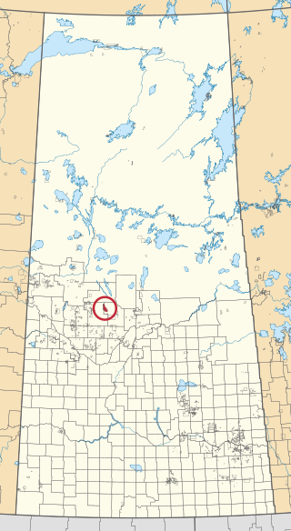
Sturgeon Lake 101 is an Indian reserve of the Sturgeon Lake First Nation in Saskatchewan. It is 29 kilometres northwest of Prince Albert. In the 2016 Canadian Census, it recorded a population of 1174 living in 287 of its 293 total private dwellings. In the same year, its Community Well-Being index was calculated at 43 of 100, compared to 58.4 for the average First Nations community and 77.5 for the average non-Indigenous community.

Sucker River 156C is an Indian reserve of the Lac La Ronge Indian Band in Saskatchewan. It is 230 kilometres north of Prince Albert. In the 2016 Canadian Census, it recorded a population of 416 living in 109 of its 124 total private dwellings. In the same year, its Community Well-Being index was calculated at 49 of 100, compared to 58.4 for the average First Nations community and 77.5 for the average non-Indigenous community.

Thunderchild 115B is an Indian reserve of the Thunderchild First Nation in Saskatchewan. It is 85 kilometres northwest of North Battleford. In the 2016 Canadian Census, it recorded a population of 706 living in 172 of its 200 total private dwellings. In the same year, its Community Well-Being index was calculated at 42 of 100, compared to 58.4 for the average First Nations community and 77.5 for the average non-Indigenous community.

Whitecap 94 is an Indian reserve of the Whitecap Dakota First Nation in Saskatchewan. It is 29 kilometres south of Saskatoon, near Dundurn. In the 2016 Canadian Census, it recorded a population of 451 living in 145 of its 166 total private dwellings. In the same year, its Community Well-Being index was calculated at 73 of 100, compared to 58.4 for the average First Nations community and 77.5 for the average non-Indigenous community.

