Hepburn, Saskatchewan

Last updated

Hepburn
Town
Town of Hepburn
Hepburn Saskatchewan 2011.jpg
Main Street (2010)
Canada Saskatchewan location map.svg
Red pog.svg
Location of Hepburn in Saskatchewan
Coordinates: 52°31′32″N106°43′50″W / 52.52556°N 106.73056°W / 52.52556; -106.73056
CountryCanada
Province Saskatchewan
Census division 15
Rural Municipality Laird No. 404
Post office established1901
Village [1] July 5, 1919
Town [1] October 24, 2012
Government
  MLARandy Weekes
  MayorDeidra Prosofsky
Area
  Total1.02 km2 (0.39 sq mi)
Population
 (2011)
  Total562
  Density550/km2 (1,400/sq mi)
Time zone UTC-6 (CST)
Postal code
Area code 306
Highways Highway 12
Highway 375

Hepburn is a town in Saskatchewan, Canada, approximately 45 kilometres north of Saskatoon.

Contents

History

Hepburn was settled in the early 20th century as a railroad station. Connection made the community grow overnight and many people moved to the area. Before the 1930s the population of Hepburn had reached over 800 people. In the 1930s, the area was affected by both the Great Depression and a huge drought affecting most of Western Canada. Many of Hepburn's residents and farmers left the area. By the end of the decade, the population was less than 300.

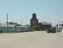
In the 1940s, the community sent over 60 men to serve in World War II. After the war, Hepburn started to grow, and new homes were built. In 1989, the province shut down the railroad line, stranding three grain elevators. Like most Saskatchewan grain elevators, two were torn down but one remained, being converted into a museum about the history of Hepburn and of Saskatchewan.

Demographics

In the 2021 Census of Population conducted by Statistics Canada, Hepburn had a population of 784 living in 268 of its 276 total private dwellings, a change of 14% from its 2016 population of 688. With a land area of 1.14 km2 (0.44 sq mi), it had a population density of 687.7/km2 (1,781.2/sq mi) in 2021. [2]

Canada census – Hepburn community profile
2021 2011
Population784 (+14.0% from 2016)562 (6.0% from 2006)
Land area1.14 km2 (0.44 sq mi)1.02 km2 (0.39 sq mi)
Population density689.4/km2 (1,786/sq mi)548.4/km2 (1,420/sq mi)
Median age33.2 (M: 33.2, F: 33.2)
Private dwellings276 (total)  268 (occupied)215 (total) 
Median household income$92,000
References: 2021 [3] 2011 [4] earlier [5] [6]

Education

Bethany College (2010) Bethany College Hepburn 2011.jpg
Bethany College (2010)

Hepburn was home to a small Bible college called Bethany College which had a population of around 73 students before closing in May 2015. Hepburn is also home to Hepburn School (elementary and high school) which in 2001 celebrated its 75th anniversary. It is believed to be the oldest school in Saskatchewan continuously operating in its original building.

Attractions

See also

Related Research Articles

Coleville is a village in the Canadian province of Saskatchewan within the Rural Municipality of Oakdale No. 320 and Census Division No. 13. The village's main economic factors are oil and farming, namesake of the Coleville oilfields. The village is named for Malcolm Cole who became the community's first postmaster in 1908.

<span class="mw-page-title-main">Rosthern</span> Town in Saskatchewan, Canada

Rosthern is a town at the juncture of Highway 11 and Highway 312 in central Saskatchewan, Canada. It is located roughly halfway between the cities of Prince Albert and Saskatoon.

<span class="mw-page-title-main">Sintaluta</span> Town in Saskatchewan, Canada

Sintaluta is a town in Saskatchewan, Canada. The population of Sintaluta is 124 people according to the 2021 Census of Population. The town is located about 85 km east of Regina. The town is on the north side of the Trans-Canada Highway.

<span class="mw-page-title-main">Hanley, Saskatchewan</span> Town in Saskatchewan, Canada

Hanley is a town in Division No. 11 in Saskatchewan, Canada. It is located 65 km south of Saskatoon. The town's population in 2011 was 522. It was named after Hanley, Staffordshire, England, by early founders. It is also the seat for the Rural Municipality of Rosedale No. 283.

Willingdon is a hamlet in central Alberta, Canada within the County of Two Hills No. 21. It is located approximately 117 km (73 mi) northeast of Edmonton, Alberta's capital city.

Schuler is a hamlet in southern Alberta, Canada within Cypress County, located 4 kilometres (2.5 mi) east of Highway 41, approximately 40 kilometres (25 mi) northeast of Medicine Hat.

<span class="mw-page-title-main">St. Walburg, Saskatchewan</span> Town in Saskatchewan, Canada

St. Walburg is a town in west-central Saskatchewan's prairie region on Highway 26. St. Walburg is surrounded by the Rural Municipality of Frenchman Butte No. 501. The Bronson Provincial Forest is about 10 kilometres (6.2 mi) to the north.

Semans is a village in the Canadian province of Saskatchewan within the Rural Municipality of Mount Hope No. 279 and Census Division No. 10. The village is located approximately 125 km north of the City of Regina and 195 km southeast of the City of Saskatoon.

<span class="mw-page-title-main">Cudworth, Saskatchewan</span> Town in Saskatchewan, Canada

Cudworth is a town in Saskatchewan, Canada. Cudworth is located approximately 85 km north-east of Saskatoon, Saskatchewan in the Minnichinas Hills. Cudworth is in hilly partially forested country east of the South Saskatchewan River. The area is part of the aspen parkland biome.

Love is a village in the Canadian province of Saskatchewan within the Rural Municipality of Torch River No. 488 and Census Division No. 14. The village is northeast of the City of Prince Albert and about 48 km (30 mi) south of Prince Albert National Park boundaries and 16 km (9.9 mi) south of Torch River Provincial Forest.

<span class="mw-page-title-main">Elrose, Saskatchewan</span> Town in Saskatchewan, Canada

Elrose is a town located just to the north of the Coteau Hills. It is south of Rosetown and north of Swift Current on Highway 4 and Highway 44. A community in the middle of an agricultural economy, Elrose has also become a local hub of activity in the oil industry. The town is surrounded by the Rural Municipality of Monet No. 257.

Cadillac is a village in the Canadian province of Saskatchewan within the Rural Municipality of Wise Creek No. 77 and Census Division No. 4. It is at the intersection of Highway 13, the Red Coat Trail, and Highway 4 in the southwest portion of the province. Located 40 mi/62 km south of the City of Swift Current, The three largest buildings remaining in the community are the former Cadillac School, the Cadillac Skating and Curling Rink, and the former Saskatchewan Wheat Pool grain elevator.

Bengough is a town surrounded by the Rural Municipality of Bengough No. 40, in the Canadian province of Saskatchewan. A southeastern Saskatchewan prairie town, Bengough is located east of Willow Bunch Lake on Highway 34 near Highway 705. The town is named Bengough after cartoonist John Wilson Bengough. Bengough also plays host to the Gateway Festival which showcases various musicians and several other events through the weekend, usually taking place in late July.

<span class="mw-page-title-main">Maidstone, Saskatchewan</span> Town in Saskatchewan, Canada

Maidstone is a town in west central Saskatchewan, Canada located 57 km east of Lloydminster and 84 km west of North Battleford at the junction of Highway 16 and Highway 21. The community was named after Maidstone, Kent, England.

<span class="mw-page-title-main">Stoughton, Saskatchewan</span> Town in Saskatchewan, Canada

Stoughton is a town in Saskatchewan, Canada. In 2011 it had a population of 649. Stoughton was originally called New Hope. The tiny settlement of New Hope was barely three years old when the Canadian Pacific Railway (CPR) arrived in this part of the province in 1904. The CPR chose a location a little to the south for its closest depot, which it called Stoughton. The community of New Hope soon moved to join it.

<span class="mw-page-title-main">Hawarden, Saskatchewan</span> Village in Saskatchewan, Canada

Hawarden is a village in the Canadian province of Saskatchewan within the Rural Municipality of Loreburn No. 254 and Census Division No. 11. The village is located on Highway 19 north of Strongfield, Loreburn, and Elbow.

<span class="mw-page-title-main">Maymont, Saskatchewan</span> Village in Saskatchewan, Canada

Maymont is a village in the Canadian province of Saskatchewan within the Rural Municipality of Mayfield No. 406 and Census Division No. 16. It is 90 kilometres (56 mi) north-west of the city of Saskatoon.

<span class="mw-page-title-main">Osler, Saskatchewan</span> Town in Saskatchewan, Canada

Osler is a town in the Canadian province of Saskatchewan, founded in the 1890s. The community was named after Sir Edmund Boyd Osler (1845–1924), who was an Ontario-based explorer, railroad financier, and Member of Parliament.

<span class="mw-page-title-main">Rural Municipality of Bengough No. 40</span> Rural municipality in Saskatchewan, Canada

The Rural Municipality of Bengough No. 40 is a rural municipality (RM) in the Canadian province of Saskatchewan within Census Division No. 2 and SARM Division No. 2. It is located in the southeast portion of the province.

<span class="mw-page-title-main">Rural Municipality of Laird No. 404</span> Rural municipality in Saskatchewan, Canada

The Rural Municipality of Laird No. 404 is a rural municipality (RM) in the Canadian province of Saskatchewan within Census Division No. 15 and SARM Division No. 5.

References

  1. 1 2 "Urban Municipality Incorporations" (PDF). Saskatchewan Ministry of Government Relations. p. 11. Archived from the original on 15 October 2014. Retrieved 5 February 2017.{{cite web}}: CS1 maint: bot: original URL status unknown (link)
  2. "Population and dwelling counts: Canada, provinces and territories, census divisions and census subdivisions (municipalities), Saskatchewan". Statistics Canada. 9 February 2022. Retrieved 1 April 2022.
  3. "2021 Community Profiles". 2021 Canadian Census . Statistics Canada. 4 February 2022. Retrieved 19 October 2023.
  4. "2011 Community Profiles". 2011 Canadian Census . Statistics Canada. 21 March 2019. Retrieved 15 April 2012.
  5. "2006 Community Profiles". 2006 Canadian Census . Statistics Canada. 20 August 2019.
  6. "2001 Community Profiles". 2001 Canadian Census . Statistics Canada. 18 July 2021.
  7. Hepburn Museum of Wheat

52°31′32″N106°43′50″W / 52.52556°N 106.73056°W / 52.52556; -106.73056