North Saskatchewan River

Last updated

North Saskatchewan River
North Saskatchewan River in the Rockies.jpg
North Saskatchewan River near Abraham Lake
North Saskatchewan basin map.png
The North Saskatchewan River drainage basin
Canada Saskatchewan relief location map.jpg
Red pog.svg
River's mouth in Saskatchewan
Canada relief map 2.svg
Red pog.svg
North Saskatchewan River (Canada)
Etymology
  • Plains Cree: 'fast current / swift-flowing river'
  • Blackfoot: 'big river'
Location
CountryCanada
Provinces
Cities
Physical characteristics
Source Rocky Mountains
  location Saskatchewan Glacier, Alberta
  coordinates 52°09′22″N117°10′54″W / 52.15611°N 117.18167°W / 52.15611; -117.18167
  elevation2,080 m (6,820 ft)
Mouth Saskatchewan River
  location
Saskatchewan River Forks, Saskatchewan
  coordinates
53°14′07″N105°04′58″W / 53.23528°N 105.08278°W / 53.23528; -105.08278
  elevation
380 m (1,250 ft)
Length1,287 km (800 mi)
Basin size122,800 km2 (47,400 sq mi)
Discharge 
  location Prince Albert, Saskatchewan, 53 km (33 mi) from the mouth
  average238 m3/s (8,400 cu ft/s)
  minimum19 m3/s (670 cu ft/s)
  maximum5,660 m3/s (200,000 cu ft/s)
Basin features
River system Nelson River
Tributaries 
  left
  right

The North Saskatchewan River is a glacier-fed river that flows from the Canadian Rockies continental divide east to central Saskatchewan, where it joins with the South Saskatchewan River to make up the Saskatchewan River. Its water flows eventually into the Hudson Bay.

Contents

The Saskatchewan River system is the largest shared between the Canadian provinces of Alberta and Saskatchewan. [1] Its watershed includes most of southern and central Alberta and Saskatchewan.

Course

The North Saskatchewan River has a length of 1,287 kilometres (800 mi), and a drainage area of 122,800 square kilometres (47,400 sq mi). [2] At its end point at Saskatchewan River Forks it has a mean discharge of 245 cubic metres per second (8,700 cu ft/s). The yearly discharge at the Alberta–Saskatchewan border is more than 7 cubic kilometres (1.7 cu mi). [3]

The river begins above 1,800 metres (5,900 ft) at the toe of the Saskatchewan Glacier in the Columbia Icefield, and flows southeast through Banff National Park alongside the Icefields Parkway. At the junction of the David Thompson Highway (Highway 11), it initially turns northeast for 10 kilometres (6.2 mi) before switching to a more direct eastern flow for about 30 kilometres (19 mi). At this point, it turns north where it eventually arrives at Abraham Lake. Bighorn Dam constricts the north end of Abraham Lake, where the North Saskatchewan emerges to track eastward to Rocky Mountain House. At Rocky Mountain House, the river abruptly turns north again for 100 kilometres (62 mi) where it switches east towards Edmonton, Alberta.

In Edmonton, the river passes through the centre of the city in a northeasterly direction and out towards Smoky Lake at which point it quickly changes to the southeast and then more to the east as it makes its way to the Alberta–Saskatchewan boundary.

From the border, the river flows southeast between North Battleford and Battleford and on in the direction of Saskatoon. About 40 kilometres (25 mi) northwest of Saskatoon, near Langham, the river veers to the northeast where it passes through the City of Prince Albert. About 30 kilometres (19 mi) downstream of Prince Albert, the North Saskatchewan River joins the South Saskatchewan River at Saskatchewan River Forks to become the Saskatchewan River. From there, the river flows east to Tobin Lake and into Manitoba, eventually emptying into Lake Winnipeg.

Geography

The river course can be divided into five distinct sections. The first, the eastern slopes of the Rocky Mountains, is the smallest area geographically, although the largest in terms of run-off and contributed water flow. The glaciers and perpetual snows of the mountain peaks feed the river year-round. Mountains, with little vegetation, experience fast-melting snow cover. The second section of the river comprises the foothills region. The terrain is hilly and rough, with a deeper and more defined valley. This area is well covered with forest and muskeg, and run-off into the river is much more constant and stable than in the mountains.

From Edmonton to the mouth of the Vermilion River, the North Saskatchewan flows through the plains-parkland divide, with occasional stretches of prairie. The North Saskatchewan River valley parks system; the largest expanses of urban parkland in Canada. [4] Cutting across Edmonton and the Capital Region. [5] The river runs in a well-defined valley with deep cuts in the landscape. The fourth section, from the Vermilion River to Prince Albert is principally prairie with a few small stretches of timber and secondary forest cover. The valley of the river is much wider, and the river itself spreads out across shallow water and flows over many shifting sand bars. Low-lying, flat areas border the river for much of this section.

The final section of the river, from Prince Albert to the Saskatchewan River Forks, has many rapids. The valley is more shallow than the previous sections of the river, and the channel is much better defined. There is little prairie and much tree cover in this section. [6]

The water flows on then in the Saskatchewan River.

Geology

The Bridge River Ash is in the vicinity of the North Saskatchewan River, which erupted from the Mount Meager massif in southwestern British Columbia about 2350 years ago.

History

The river is shown on a Hudson's Bay Company (HBC) map from 1760, labelled as the Beaver River. [7]

Its Cree name is kisiskâciwanisîpiy, meaning 'swift current'. From this name is derived the name Saskatchewan, used as well for the South Saskatchewan River and the Saskatchewan River (of which both the North and South Saskatchewan rivers are major tributaries), and the province of that name. [8]

Its Blackfoot name is omaka-ty 'big river'. [9]

The North Saskatchewan in Edmonton circa 1913. Steamboats in the foreground, construction of the High Level Bridge in the background, and mid-river piers for future Walterdale Bridge between. North Saskatchewan River circa 1913.jpg
The North Saskatchewan in Edmonton circa 1913. Steamboats in the foreground, construction of the High Level Bridge in the background, and mid-river piers for future Walterdale Bridge between.

The 49-kilometre section of the North Saskatchewan River that falls within the boundaries of Banff National Park was designated a Canadian Heritage River in 1989, due to its importance in the development of Western Canada. [10] In 2022 the remaining 718 km within Alberta, flowing through 16 municipalities in the province, was nominated to the Canadian Heritage Rivers System, achieving final designation in March of 2024. [11] [12]

The river demarcates the prairie–parkland divide for much of its course and acted as a natural boundary between plains Blackfoot of the south and woodland Cree of the north for thousands of years. Archaeologists have found evidence and indications of nearly 800 permanent or temporary occupation and quarry sites in the Edmonton region alone, dating back hundreds and sometimes thousands of years. [8] With the westward expansion of the fur trade spearheaded by the North West Company (NWC) and followed by the HBC, the river became an important transportation route for fur trade brigades' York boats, to which it was especially well suited as it follows an eastern trend toward Hudson Bay, the entry point for the HBC into the continent. Many fur trade posts were constructed on the river, including Fort Edmonton (1795) and Rocky Mountain House, the uppermost post reached by canoe navigation. The river's importance continued after the amalgamation of the HBC and the NWC. The river was plied by a number of steamboats up to the First World War, although for everyday freight the growing web of railway lines in the western prairies eventually replaced them. The river was used commercially for many years  to carry flatboats of settlers goods and construction materials downstream from Edmonton, to float thousands of logs in the annual log drive downstream to Edmonton prior to the First World War, as a source of ice blocks for home owners' iceboxes.[ citation needed ]

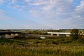
The first bridge across the river opened in 1900, the Low Level Bridge (Edmonton). The Canadian Northern Railway Bridge (Prince Albert) (1907-9), which also at first carried foot and wheeled traffic, and the Battleford bridge (ca. 1908) followed.[ citation needed ]

Recreation

The North Saskatchewan River flowing past the West River's Edge park in Fort Saskatchewan, Alberta North Saskatchewan River 2020.jpg
The North Saskatchewan River flowing past the West River's Edge park in Fort Saskatchewan, Alberta

Edmonton's North Saskatchewan River valley parks system is the largest system of urban parks in Canada, and covers both sides of the river valley's course through Edmonton. [13] The River Valley Alliance, a non-profit organization composed of seven municipalities which border the North Saskatchewan River, is currently working to create a continuous trail network from the town of Devon to the city of Fort Saskatchewan – a total of 100 kilometres (62 mi). [14]

Fish species

Fish species include: walleye, sauger, yellow perch, northern pike, goldeye, mooneye, lake sturgeon, mountain whitefish, burbot, longnose sucker, white sucker and shorthead redhorse. [15] The upper North Saskatchewan River contains cutthroat trout (although not native), [16] and bull trout [17]

Flooding

Like all rivers, the North Saskatchewan is subject to periodic flooding, beginning with rapid snowmelt in the mountains or prolonged periods of rain in the river basin. With the establishment of permanent communities along the river's course, and the rise of an administrative/government structure, records exist recording floods in the North Saskatchewan for the past century. The Bighorn Dam, constructed in the early 1970s near Nordegg, Alberta, and the Brazeau Dam, constructed in the mid-1960s, have not reduced flooding potential on the North Saskatchewan River (Alberta Environment 1981) [18]

29 June 1915 cover of the Edmonton Daily Bulletin Edmonton daily bulletin 1915 flood cover.jpg
29 June 1915 cover of the Edmonton Daily Bulletin

List of notable flood years

[19] [20]

Year Edmonton Prince Albert
Peak datemean daily flow
(m3/s)
Peak datePeak flow
(m3/s)
189918 August4570August3960
191210 July210014 July1980
19 August199025 August1550
19149 June175014 June1790
191529 June46402 July5300
16 July255021 July2320
191718 May186023 May1540
192325 June238030 June1640
192518 August215023 August1620
19324 June187010 June2160
194416 June345020 June2940
194825 May185031 May2090
195225 June354029 June2970
19548 June303012 June2790
27 August28201 Sept2570
196529 June25904 July2460
19697 July174013 July1570
197227 June29702 July2340
197423 April3880
19807 June174013 June1680
19826 July192013 July1580
198619 July399024 July3230
19904 July234010 July1890
200521 June227027 June1800
201119 June180026 June2100
201323 June271029 June2200

Flood of 1899

The river peaked at a stage of 12.61 metres (41.4 ft) with an estimated peak instantaneous discharge of 5,100 cubic metres per second (180,000 cu ft/s).[ citation needed ]

Flood of 1915

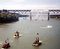
The 1915 flood of the North Saskatchewan River was one of the most dramatic in the history of Edmonton. On 28 June, the Edmonton Bulletin reported the river had risen "10 feet in as many hours" and ultimately hitting a height of 42 feet over the low water level. [21] A frantic phone call from Rocky Mountain House alerted local authorities to the flood's arrival. [22] The Canadian Northern Railway had parked a number of train cars on the city's Low Level Bridge to protect against the "tons upon tons of debris" that had been pushed up against its piers, including a house swept away by the current. [23] Thousands of Edmonton residents watched the flood destroy lumber mills, other industries and dozens of houses along the city's river valley. [23] [21]

The river peaked at a stage of 13.73 metres (45.0 ft), a rise of 11.5 metres (38 ft) above low flow, with an estimated peak instantaneous discharge of 5,800 cubic metres per second (200,000 cu ft/s). However, based on high water marks and 1D modelling, the actual value may have been closer to 6,300 cubic metres per second (220,000 cu ft/s).[ citation needed ]

Flood of 1986

The river peaked at a stage of 11.5 metres (38 ft) with a peak instantaneous discharge of 4,520 cubic metres per second (160,000 cu ft/s).[ citation needed ]

2013 Alberta Flooding

Along with many other rivers in central and southern Alberta during late June, the North Saskatchewan saw significantly higher water levels and flow rates. The river peaked at a stage of 9.03 m (29.6 ft) with a peak instantaneous discharge of 2,710 cubic metres per second (96,000 cu ft/s) on June 23 in Edmonton. [24] This is significantly higher than the Bow River's peak height at 4.1 metres (13 ft) and peak discharge of 1,750 cubic metres per second (62,000 cu ft/s) on June 21, that caused widespread flooding in Calgary. [25] However, due to the expansive North Saskatchewan River Valley and natural sanctuary/parkland that surrounds it, the City of Edmonton had only minor, isolated flooding, with virtually no major property damage as a result.[ citation needed ]

Commercial navigation

The North Saskatchewan River has always been a major trade route from Hudson Bay and central Canada across the Canadian Prairies to the Canadian Rockies. During the fur trade era, birch bark canoes and York boats travelled up and down the Saskatchewan delivering trade goods and amassing furs for transportation to Europe.[ citation needed ]

The North Saskatchewan also witnessed a lively, although short-lived, era of steamboat shipping during the 1870s, 1880s, and 1890s. The Hudson's Bay Company (HBC) purchased a number of steamboats from companies operating on the Red River and trading at Winnipeg/Fort Garry. The HBC desired to avoid paying the labour costs of fur trade brigades, and hoped steamboat shipping would provide a suitable alternative. Several HBC steamboats navigated the river intermittently for many years, although fluctuating water levels and natural barriers (rapids and sandbars) hampered efficient operation. [26]

With the arrival of the railroad in Western Canada, steamboat shipping on the North Saskatchewan tapered off, but steamboats operated in the Edmonton area until the economic crash of 1912-14. [27]

Dams and hydroelectric development

A number of dams have been planned and constructed on the North Saskatchewan River and its tributaries. No singular purpose has dominated dam planning in the basin, indeed, hydroelectric development, flood control, and water diversion schemes have all underpinned proposals to construct dams on the river.[ citation needed ]

Planned dams

The first hydroelectric development on the North Saskatchewan was planned in 1910 near the Town of Drayton Valley. Funding for the plan came from a British syndicate; design and construction were to be carried out by the Edmonton Hydro-Electric Power Scheme. The development was shelved after the outbreak of World War I. [28]

The La Colle Falls hydroelectric project east of Prince Albert was a half-built failure. Construction began in the 1910s and was later abandoned. [29] The city remained in debt from financing the project until 1960, and the site still attracts tourists today. [30]

During the 1960s and 1970s, a major dam was planned on the North Saskatchewan near the Hamlet of Hairy Hill, Alberta, about 160 kilometres (100 mi) downstream from Edmonton. This dam was part of a larger interbasin water diversion conceived by the Alberta Government to transfer water from the Peace, Smoky, and Athabasca rivers to the Saskatchewan River Basin. [31]

The planned dam had a maximum height of 65 metres (212 ft), with a crest length of 1.76 kilometres (5,760 ft), which would have created a reservoir capable of holding over 4.9 cubic kilometres (4,000,000 acre⋅ft) of water. The reservoir would have affected municipal water works in the City of Fort Saskatchewan, was likely to inundate part of the Saddle Lake Indian reserve, and would have flooded a number of oil and natural gas fields in the area. [32] The plan was later shelved in light of economic and environmental concerns.[ citation needed ]

Constructed dams

The Bighorn Dam was constructed near Nordegg and created Abraham Lake, one of the largest reservoirs in Alberta. The dam was constructed in 1972 by Calgary Power. [33] The Bighorn Plant has a generating capacity of 120 megawatts (MW), and has an available water supply that allows it to be the largest producer of hydroelectric electricity in Alberta, with an average of 408,000 megawatt hours (MW⋅h) each year. [33]

One of the North Saskatchewan's major tributaries, the Brazeau River, houses the Brazeau Hydroelectric Plant. At 355 MW, the Brazeau Dam is Alberta's largest hydroelectric facility, and was built in 1965 by Calgary Power. [34] Though having a higher peak generating capacity than the Bighorn Dam, the hydrology of the Brazeau means that its average annual electricity production is a slightly smaller 397,000 MW⋅h. [34]

Tributaries

[35]

See also

Further reading

Related Research Articles

<span class="mw-page-title-main">Upper Rhine</span> Section of the Rhine in Germany and Switzerland

The Upper Rhine is the section of the Rhine between Basel in Switzerland and Bingen in Germany, surrounded by the Upper Rhine Plain. The river is marked by Rhine-kilometres 170 to 529.

<span class="mw-page-title-main">Fraser River</span> River in British Columbia, Canada

The Fraser River is the longest river within British Columbia, Canada, rising at Fraser Pass near Blackrock Mountain in the Rocky Mountains and flowing for 1,375 kilometres (854 mi), into the Strait of Georgia just south of the City of Vancouver. The river's annual discharge at its mouth is 112 cubic kilometres (27 cu mi) or 3,550 cubic metres per second (125,000 cu ft/s), and each year it discharges about 20 million tons of sediment into the ocean.

<span class="mw-page-title-main">Saskatchewan River</span> River in western Canada

The Saskatchewan River is a major river in Canada. It stretches about 550 kilometres (340 mi) from where it is formed by the joining together of the North Saskatchewan River and South Saskatchewan River just east of Prince Albert, Saskatchewan, to Lake Winnipeg. It flows roughly eastward across Saskatchewan and Manitoba to empty into Lake Winnipeg. Through its tributaries the North Saskatchewan and South Saskatchewan, its watershed encompasses much of the prairie regions of Canada, stretching westward to the Rocky Mountains in Alberta and north-western Montana in the United States.

<span class="mw-page-title-main">Mackenzie River</span> Largest river system in Canada

The Mackenzie River is a river in the Canadian boreal forest. It forms, along with the Slave, Peace, and Finlay, the longest river system in Canada, and includes the second largest drainage basin of any North American river after the Mississippi.

<span class="mw-page-title-main">South Saskatchewan River</span> River in Western Canada

The South Saskatchewan River is a major river in the Canadian provinces of Alberta and Saskatchewan. The river begins at the confluence of the Bow and Oldman Rivers in southern Alberta and ends at the Saskatchewan River Forks in central Saskatchewan. The Saskatchewan River Forks is the confluence of the South and North Saskatchewan Rivers and is the beginning of the Saskatchewan River.

<span class="mw-page-title-main">Assiniboine River</span> River in Western Canada

The Assiniboine River is a 1,070-kilometre (660 mi) river that runs through the prairies of Western Canada in Saskatchewan and Manitoba. It is a tributary of the Red River. The Assiniboine is a typical meandering river with a single main channel embanked within a flat, shallow valley in some places and a steep valley in others. Its main tributaries are the Qu'Appelle, Souris, and Whitesand Rivers. For early history and exploration see Assiniboine River fur trade.

<span class="mw-page-title-main">Clutha River</span> River in the South Island of New Zealand

The Clutha River is the second longest river in New Zealand and the longest in the South Island. It flows south-southeast 338 kilometres (210 mi) through Central and South Otago from Lake Wānaka in the Southern Alps to the Pacific Ocean, 75 kilometres (47 mi) south west of Dunedin. It is the highest volume river in New Zealand, and the swiftest, with a catchment of 21,000 square kilometres (8,100 sq mi), discharging a mean flow of 614 cubic metres per second (21,700 cu ft/s). The river is known for its scenery, gold-rush history, and swift turquoise waters. A river conservation group, the Clutha Mata-Au River Parkway Group, is working to establish a regional river parkway, with a trail, along the entire river corridor.

<span class="mw-page-title-main">Souris River</span> River in Canada and the United States

The Souris River or Mouse River is a river in central North America. Approximately 435 miles (700 km) in length, it drains about 23,600 square miles (61,100 km2) in Canada and the United States.

<span class="mw-page-title-main">Kootenay River</span> River in Western Canada and the United States

The Kootenay River or Kootenai River is a major river of the Northwest Plateau in southeastern British Columbia, Canada, and northern Montana and Idaho in the United States. It is one of the uppermost major tributaries of the Columbia River, the largest North American river that empties into the Pacific Ocean. The Kootenay River runs 781 kilometres (485 mi) from its headwaters in the Kootenay Ranges of the Canadian Rockies, flowing from British Columbia's East Kootenay region into northwestern Montana, then west into the northernmost Idaho Panhandle and returning to British Columbia in the West Kootenay region, where it joins the Columbia at Castlegar.

<span class="mw-page-title-main">Durance</span> River in France

The Durance is a major river in Southeastern France. A left tributary of the Rhône, it is 323.2 km (200.8 mi) long. Its drainage basin is 14,472 km2 (5,588 sq mi).

<span class="mw-page-title-main">Freshet</span> High water levels caused by melting snow and ice

The term freshet is most commonly used to describe a snowmelt, an annual high water event on rivers resulting from snow and river ice melting. A spring freshet can sometimes last several weeks on large river systems, resulting in significant inundation of flood plains as the snowpack melts in the river's watershed. Freshets can occur with differing strength and duration depending upon the depth of the snowpack and the local average rates of warming temperatures. Deeper snowpacks which melt quickly can result in more severe flooding. Late spring melts allow for faster flooding; this is because the relatively longer days and higher solar angle allow for average melting temperatures to be reached quickly, causing snow to melt rapidly. Snowpacks at higher altitudes and in mountainous areas remain cold and tend to melt over a longer period of time and thus do not contribute to major flooding. Serious flooding from freshets in southern US states are more often related to rain storms of large tropical weather systems rolling in from the South Atlantic or Gulf of Mexico, to add their powerful heating capacity to lesser snow packs. Tropically induced rainfall influenced quick melts can also affect snow cover to latitudes as far north as southern Canada, so long as the generally colder air mass is not blocking northward movement of low pressure systems.

<span class="mw-page-title-main">Eucumbene Dam</span> Dam in Snowy Mountains, New South Wales

Eucumbene Dam is a major gated earthfill embankment dam with an overflow ski-jump and bucket spillway with two vertical lift gates across the Eucumbene River in the Snowy Mountains of New South Wales, Australia. The dam's main purpose is for the generation of hydro-power and is one of the sixteen major dams that comprise the Snowy Mountains Scheme, a vast hydroelectricity and irrigation complex constructed in south-east Australia between 1949 and 1974 and now run by Snowy Hydro.

<span class="mw-page-title-main">Brazeau River</span> River in Alberta, Canada

The Brazeau River is a river in western Alberta, Canada. It is a major tributary of the North Saskatchewan River.

<span class="mw-page-title-main">Bighorn Dam</span> Dam in Alberta, Canada

Bighorn Dam is an embankment dam located in Clearwater County in west-central Alberta, Canada. It was built by Calgary Power in 1972, and led to the creation of Lake Abraham, Alberta's largest reservoir. The dam and associated hydroelectric plant are managed by TransAlta.

<span class="mw-page-title-main">Lhasa River</span> River in Tibet

The Lhasa River, also called Kyi Chu, is a northern tributary of the Yarlung Tsangpo River in the south of the Tibet Autonomous Region of China. The Yarlung Tsangpo is the upper section of the Brahmaputra River. The Lhasa River is subject to flooding with the summer monsoon rains, and structures have been built to control the floods. In its lower reaches the river valley is an important agricultural area. The city of Lhasa, named after the river, lies on the river. There are two large hydroelectric power stations on the river, the Zhikong Hydro Power Station (100 MW) and the Pangduo Hydro Power Station (160 MW)

<span class="mw-page-title-main">Brazeau Reservoir</span> Lake in Alberta, Canada

Brazeau Reservoir is a large man made reservoir in Alberta, Canada.

<span class="mw-page-title-main">Saskatchewan River Delta</span> Inland river delta in Western Canada

The Saskatchewan River Delta (SRD), also known as Cumberland Marshes, is a large alluvial delta that straddles the border of the provinces of Saskatchewan and Manitoba in Western Canada. Currently terminating at Cedar Lake, Manitoba, the delta is composed mainly of various types of wetlands, shallow lakes, and active and abandoned river channels bordered by forested natural levees. Sixty-five percent of the delta is occupied by vegetated wetlands, over one third of which comprise peat-forming fens and bogs. Geographically, the SRD consists of two parts – western and eastern – separated by a prominent moraine that was deposited by the Laurentide Ice Sheet during late stages of the Wisconsinan glacial epoch. These two components, commonly termed the "upper delta" and "lower delta", together occupy an area of approximately 10,000 km2 (3,900 sq mi) making the SRD one of the largest active inland deltas in North America. The broad wetland tracts of the upper delta in Saskatchewan are sometimes referred to as the Cumberland Marshes. Approximately 5% of the delta surface has been drained for agricultural use following feasibility studies by the Prairie Farm Rehabilitation Administration in the 1950s.

<span class="mw-page-title-main">Jounama Dam</span> Dam in Snowy Mountains, New South Wales

Jounama Dam is a major ungated rockfill embankment dam across the Tumut River in the Snowy Mountains of New South Wales, Australia. The dam's main purpose is for the generation of hydro-power and is one of the sixteen major dams that comprise the Snowy Mountains Scheme, a vast hydroelectricity and irrigation complex constructed in south-east Australia between 1949 and 1974 and now run by Snowy Hydro.

<span class="mw-page-title-main">Guthega Dam</span> Dam in Snowy Mountains, New South Wales

Guthega Dam is concrete gravity dam with an uncontrolled spillway across the Snowy River in the Snowy Mountains of New South Wales, Australia. The dam's main purpose is for the storage of water used in the generation of hydro-power. It is the first to be completed of the sixteen major dams of the Snowy Mountains Scheme, a vast hydroelectricity and irrigation complex constructed in south-east Australia between 1949 and 1974 and now run by Snowy Hydro.

<span class="mw-page-title-main">North Saskatchewan River flood of 1915</span> 1915 natural disaster in Edmonton, Alberta, Canada

The North Saskatchewan River flood of 1915 was one of the largest floods in the history of Edmonton. On 28 June, the Edmonton Bulletin reported the river had risen "10 feet [3.0 m] in as many hours." A frantic telegram from Rocky Mountain House alerted local authorities to the flood's arrival.

References

  1. "Saskatchewan River". Encyclopædia Britannica. 2006. Retrieved September 22, 2006.
  2. Atlas of Canada. "Major Rivers in Canada". Archived from the original on April 4, 2007. Retrieved May 1, 2007.
  3. Alberta Environment - Alberta river basins [ dead link ]
  4. "River Valley Parks". City of Edmonton. Retrieved March 31, 2016.
  5. "Ribbon of Green Concept Plan: Basic Principles". City of Edmonton. Archived from the original on March 26, 2016. Retrieved March 31, 2016.
  6. Surveys of the North Saskatchewan River: 1910-1915. Edmonton: Government of the Province of Alberta, Department of Water Resources, 1917. Pages 50-53.
  7. MacDonald, 3[ citation needed ]
  8. 1 2 Chalifoux, Jenna (June 7, 2016). "Kisiskāciwani-sīpiy – Swift Flowing River". Edmonton City as Museum Projec. Edmonton Heritage Council. Retrieved March 26, 2024.
  9. Geographic Board of Canada. Place Names of Alberta (1928)
  10. "North Saskatchewan River". Canadian Heritage River System. 2011. Retrieved July 9, 2015.
  11. "Governments of Canada and Alberta officially accept nomination of the Alberta section of the North Saskatchewan River as a Canadian Heritage River". August 3, 2022. Retrieved August 25, 2023.
  12. Chowdhury, Nishat (March 24, 2024). "Alberta's North Saskatchewan earns heritage river status". CBC News. Retrieved March 26, 2024.
  13. Edmonton, City of (July 18, 2020). "River Valley Parks". www.edmonton.ca. Retrieved July 18, 2020.
  14. "River Valley Alliance". River Valley Alliance. Retrieved July 18, 2020.
  15. "Fish Species of Saskatchewan". Government of Saskatchewan. Archived from the original on November 3, 2015.
  16. "Cutthroat trout". www.alberta.ca. Retrieved August 30, 2019.
  17. "Upper North Saskatchewan River and Abraham Lake Bull Trout Study" (PDF). Alberta Conservation. Archived from the original (PDF) on July 28, 2019.
  18. Mustapha, A. M. (1981). History of Floods in the North Saskatchewan River Basin (Report). Alberta Environment, Environmental Engineering Support Services, Technical Services Division.
  19. Research Council of Alberta, Highways Division. Hydrologic Data on Floods in the North Saskatchewan River. (Edmonton: Research Council of Alberta, 1965).
  20. "Archived copy". Archived from the original on December 31, 2007. Retrieved January 2, 2008.{{cite web}}: CS1 maint: archived copy as title (link) Environment Canada, Water Survey of Canada, retrieved 11 January 2009.
  21. 1 2 Scott, Sally (June 29, 2015). "June 29, 1915 — Edmonton's River Valley Floods". Edmonton City as Museum Project. Edmonton Heritage Council. Retrieved March 26, 2024.
  22. The Edmonton Bulletin, 28 June 1915.
  23. 1 2 The Edmonton Bulletin, 29 June 1915.
  24. "Disclaimer for Hydrometric Information - Water Level and Flow - Environment Canada". wateroffice.ec.gc.ca.
  25. "Disclaimer for Hydrometric Information - Water Level and Flow - Environment Canada". wateroffice.ec.gc.ca.
  26. Bruce Peel, Steamboats on the Saskatchewan, (Saskatoon: Prairie Books, 1972)
  27. Tom Monto, Old Strathcona - Edmonton's Southside Roots (Alhambra Books/Crang Publishing (2011).
  28. Loosmore, W. S. B. To Trail's End: Early Settlement in Drayton Valley. Drayton Valley: Drayton Valley and District Historical Society, 1994. Pages 10-14.
  29. Saskatchewan Settlement Experience Archived 2011-07-16 at the Wayback Machine . Sasksettlement.com. Retrieved on 2013-07-12.
  30. Saskatchewan Settlement Experience Archived 2011-07-16 at the Wayback Machine . Sasksettlement.com. Retrieved on 2013-07-12.
  31. Athabasca River Historical Report. albertawater.com. Retrieved on 2018-03-01.
  32. Prairie Farm Rehabilitation Administration, Engineering Services, Alberta Regional Division. Hariy Hill Dam—North Saskatchewan River, Engineering Report. Calgary: Saskatchewan-Nelson Basin Board, 1970.
  33. 1 2 "Bighorn". www.transalta.com . Retrieved December 26, 2017.
  34. 1 2 "Brazeau". www.transalta.com . Retrieved December 26, 2017.
  35. Milholland, Billie. North Saskatchewan River Guide: Mountain to Prairie a Living Landscape. Edmonton: North Saskatchewan Watershed Alliance, 2002.