Crowsnest Lake (Alberta)

Last updated
Crowsnest Lake
Crowsnest pass.jpg
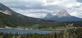
Crowsnest Lake, looking east toward Crowsnest Mountain
Canada Alberta relief location map - transverse mercator proj.svg
Red pog.svg
Crowsnest Lake
Location Municipality of Crowsnest Pass, Alberta
Coordinates 49°37′58″N114°38′16″W / 49.63278°N 114.63778°W / 49.63278; -114.63778
Basin  countriesCanada
Max. length0.9 km (0.56 mi)
Max. width3 km (1.9 mi)
Surface area1.19 km2 (0.46 sq mi)
Average depth13.5 m (44 ft)
Max. depth27.4 m (90 ft)
Surface elevation1,357 m (4,452 ft)
References Crowsnest Lake

Crowsnest Lake is a lake in southwestern Alberta, Canada. It lies near the summit of the Crowsnest Pass in the southern Canadian Rockies and gives rise to the Crowsnest River. [1]

Related Research Articles

<span class="mw-page-title-main">Crowsnest Highway</span> Canadian cross-provincial highway (est. 1932)

The Crowsnest Highway is an east-west highway in British Columbia and Alberta, Canada. It stretches 1,161 km (721 mi) across the southern portions of both provinces, from Hope, British Columbia to Medicine Hat, Alberta, providing the shortest highway connection between the Lower Mainland and southeast Alberta through the Canadian Rockies. Mostly two-lane, the highway was officially designated in 1932, mainly following a mid-19th-century gold rush trail originally traced out by an engineer named Edgar Dewdney. It takes its name from the Crowsnest Pass, the location at which the highway crosses the Continental Divide between British Columbia and Alberta.

<span class="mw-page-title-main">Crowsnest Pass</span> Mountain pass in Alberta and British Columbia, Canada

Crowsnest Pass is a low mountain pass across the Continental Divide of the Canadian Rockies on the Alberta–British Columbia border.

HMCS <i>Toronto</i> (K538) Royal Canadian naval vessel

HMCS Toronto was a River-class frigate that served in the Royal Canadian Navy during the Second World War and as a Prestonian-class frigate from 1953-1956. She was named for Toronto, Ontario. She was later acquired by the Royal Norwegian Navy and renamed Garm and then again in 1965 as HNoMS Valkyrien.

Highway 3B is an alternate loop to the Crowsnest Highway between Nancy Greene Lake and an area called Meadows, just west of Erie on the Crowsnest. Originally, Highway 3B went between Nancy Greene Lake to Trail, where the Crowsnest picked up the route to the Meadows area. One of its original component sections, the Rossland and Nancy Greene Lake was opened on the 1st of October 1965 at a cost of $3.5 million

Highway 95 is a north-south highway in the southeastern corner of British Columbia, opened in 1957. The highway connects with U.S. Route 95, from which the highway takes its number, at the Canada–U.S. border at Kingsgate, just north of Eastport, Idaho. The section between the Canada-U.S. border and the Crowsnest Highway is known as the Yahk–Kingsgate Highway while the section between the Crowsnest Highway and Golden is known as the Kootenay–Columbia Highway.

Highway 93 is a north–south route through the southeastern part of British Columbia, in the Regional District of East Kootenay and takes its number from U.S. Highway 93 that it connects with at the Canada–United States border. It follows the Crowsnest Highway (Highway 3) and Highway 95 through Radium Hot Springs and to where it crosses the Continental Divide into Alberta at Vermilion Pass, where it continues as Alberta Highway 93. The section between the Canada-U.S. border and the Crowsnest Highway is known as the Elko–Roosville Highway, the section between the Crowsnest Highway and Radium Hot Springs is known as the Kootenay–Columbia Highway, while the section east of Radium Hot Springs is known as the Banff–Windermere Parkway.

<span class="mw-page-title-main">Oldman River</span> River in Alberta, Canada

The Oldman River is a river in southern Alberta, Canada. It flows roughly west to east from the Rocky Mountains, through the communities of Fort Macleod, Lethbridge, and on to Grassy Lake, where it joins the Bow River to form the South Saskatchewan River, which eventually drains into the Hudson Bay.

<span class="mw-page-title-main">Crowsnest Pass, Alberta</span> Specialized municipality in Alberta, Canada

The Municipality of Crowsnest Pass is a specialized municipality in southwest Alberta, Canada. Within the Rocky Mountains adjacent to the eponymous Crowsnest Pass, the municipality formed as a result of the 1979 amalgamation of five municipalities – the Village of Bellevue, the Town of Blairmore, the Town of Coleman, the Village of Frank, and Improvement District No. 5, which included the Hamlet of Hillcrest and numerous other unincorporated communities.

<span class="mw-page-title-main">Crowsnest River</span> River in Alberta, Canada

The Crowsnest River is a tributary to the Oldman River in southwestern Alberta, Canada.

<span class="mw-page-title-main">Alberta Highway 6</span> Highway in Alberta, Canada

Alberta Provincial Highway No. 6, commonly referred to as Highway 6, is a north-south highway in southern Alberta, Canada. It spans approximately 74 kilometres (46 mi) from Alberta's border with Montana to Highway 3.

Crowsnest Provincial Park is a provincial park in British Columbia, Canada, located within the District Municipality of Sparwood, 51 km (32 mi) east of Fernie on BC Highway 3, just inside the BC side of the Crowsnest Pass.

<span class="mw-page-title-main">Crowsnest Range</span> Mountain range in Alberta/British Columbia

Crowsnest Range is a mountain range of the Rocky Mountains in southwestern Alberta and southeastern British Columbia, Canada.

<span class="mw-page-title-main">Crow Rate</span>

The Crow Rate, or Crowsnest Freight Rate, was a rail transportation subsidy benefiting farmers on the Canadian Prairies and manufacturers in Central Canada by rate requirements imposed on the Canadian Pacific Railway (CPR) by the Government of Canada in exchange for financing and other benefits.

<i>Moyie</i> (sternwheeler)

The Moyie is a paddle steamer sternwheeler that worked on Kootenay Lake in British Columbia, Canada from 1898 until 1957.

British Columbia Highway 3, officially named the Crowsnest Highway, is an 841-kilometre (523 mi) highway that traverses southern British Columbia, Canada. It runs from the Trans-Canada Highway (Highway 1) at Hope to Crowsnest Pass at the Alberta border and forms the western portion of the interprovincial Crowsnest Highway that runs from Hope to Medicine Hat, Alberta. The highway is considered a Core Route of the National Highway System.

Bay-class minesweeper

The Bay-class minesweepers, also known as the Gaspé-class minesweepers, were a class of minesweepers operated by the Royal Canadian Navy (RCN) and Canadian Forces (CF) during the Cold War. Their design was similar to the British Ton-class minesweepers.

HMCS<i> Star</i> Military unit

HMCS Star is a Canadian Forces Naval Reserve Division (NRD) located in Hamilton, Ontario. Dubbed a stone frigate, HMCS Star is a land-based naval establishment for training part-time sailors as well as functioning as a local recruitment centre for the Royal Canadian Navy (RCN). The second oldest of 24 naval reserve divisions located in major cities across Canada, Star was stood up on 15 March 1923 as the Royal Canadian Naval Volunteer Reserve (RCNVR) Hamilton Half Company and then on 1 November 1941 as HMCS Star.

HMCS Lauzon was a River-class frigate that served with the Royal Canadian Navy during the Second World War and again as a Prestonian-class frigate from 1953-1963. During the war she served primarily as an ocean escort for convoys. She was named for Lauzon, Quebec.

HMCS <i>Outremont</i>

HMCS Outremont was a River-class frigate that served with the Royal Canadian Navy during the Second World War and again from 1955–1965 as a Prestonian-class frigate. During the war she served primarily as a convoy escort. She was named for Outremont, Quebec.

HMCS<i> Hunter</i> Military unit

HMCS Hunter is a Canadian Forces Naval Reserve Division (NRD) located in Windsor, Ontario. Dubbed a stone frigate, HMCS Hunter is a land-based naval training establishment crewed by part-time sailors and also serves as a local recruitment centre for the Canadian Forces Naval Reserve. It is one of 24 naval reserve divisions located in major cities across Canada.

References

  1. Canada NTS Map 82G/10 Crowsnest, 1:50,000.