The Ogoki River is a river in the Thunder Bay and Cochrane Districts of Ontario. It springs from the wilderness just east of Savant Lake, flowing north of Lake Nipigon to Ogoki, where it joins the Albany River which empties into James Bay. The river is 480 kilometres (300 mi) long.
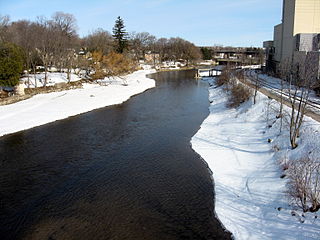
The Speed River is a river that flows through Wellington County and the Region of Waterloo in southwestern Ontario, Canada. It flows south from its source near Orton, through Guelph, where it is joined by the Eramosa River, then through the towns of Hespeler and Preston, finally uniting with the Grand River in north-west Cambridge.

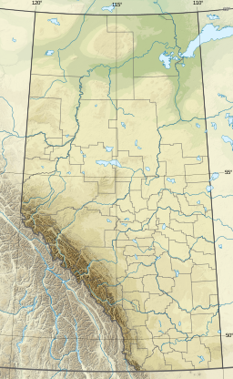
Parkland County is a municipal district in central Alberta, Canada. Located west of Edmonton in Census Division No. 11, its municipal office, Parkland County Centre, is located 0.25 km (0.16 mi) north of the Town of Stony Plain on Highway 779.

Wabamun is a hamlet in central Alberta, Canada within Parkland County. It is approximately 67 kilometres (42 mi) west of Edmonton on Highway 16. It held village status prior to 2021.

The Hillsboro Canal is located in the southeastern portion of Florida within the South Florida Water Management District, and for much of its length forms the border between Broward and Palm Beach counties; however, its western end was entirely in Palm Beach County, until being recently annexed to Broward County-Parkland, FL. It begins at Lake Okeechobee at the S-2 water control structure in South Bay west of Belle Glade, Florida. It passes within the southern border of the Loxahatchee National Wildlife Refuge and flows southeast from there along Loxahatchee Road in a rural, lightly populated area. When it reaches the more heavily built-up region further east, it bends to head due eastward, forming the county line. Near its eastern end at the Intracoastal Waterway, with Boca Raton to the north and Deerfield Beach to the south, it departs from its straight course to go around several curves, but the county boundary continues to follow it at this point. 10 miles of the canal is navigable, and it is popular for recreational boating and fishing.
Crimson Lake Provincial Park is a provincial park located in Alberta, Canada, 14 kilometres (8.7 mi) west of Rocky Mountain House, off the David Thompson Highway along secondary highway 756.
Long Lake Provincial Park is a provincial park located in Alberta, Canada. Long Lake is located one and one half hours from Edmonton along Highway 831, south of the village of Boyle and northeast of the hamlet of Newbrook, within Thorhild County.

Pymatuning State Park is a Pennsylvania state park covering 21,122 acres (8,548 ha) in Conneaut, North Shenango, Pine, Sadsbury, South Shenango, West Fallowfield and West Shenango Townships, Crawford County, Pennsylvania, in the United States. Pymatuning State Park is the largest state park in Pennsylvania and contains the 17,088 acres (6,915 ha) of Pymatuning Lake, three-quarters of which is in Pennsylvania and one-quarter of which is in Ohio. A three-mile (5 km) causeway extends between Pennsylvania and Ohio near the center of the lake. The lake provides fishing and boating year round. There are two natural areas, Clark Island and Blackjack in the park. The park is also home to the University of Pittsburgh's Pymatuning Laboratory of Ecology. Like all Pennsylvania state parks, admission to the Pymatuning State Park is free. The northern access for Pymatuning State Park can be reached from U.S. Route 6 and the southern access is reached from U.S. Route 322.

Carlyle Lake is a 25,000-acre (101.2 km2) reservoir largely located in Clinton County, Illinois, with smaller portions of the lake within Bond and Fayette counties. It is the largest man-made lake in Illinois, and the largest lake wholly contained within the state.

Locust Lake State Park is a Pennsylvania state park on 1,089 acres (441 ha) in Ryan Township, Schuylkill County, Pennsylvania in the United States. Locust Lake State Park is located approximately 7 miles (11 km) north of Pottsville, 3 miles (5 km) south of Mahanoy City, 8 miles (13 km) west of Tamaqua and 6 miles (10 km) west of Tuscarora State Park. The lake is 52 acres (21 ha). The park offers hiking, camping, boating, fishing, swimming, biking, and a wide array of other seasonal activities.

Promised Land State Park is a Pennsylvania state park in Blooming Grove, Greene and Palmyra Townships, Pike County, Pennsylvania, in the United States. The approximately 3,000-acre (1,214 ha) park is mostly surrounded by Delaware State Forest. It is in the Poconos and sits at an elevation of 1,800 feet (549 m). The second growth forests in Promised Land State Park are made up of beech, maple, oak and hemlock trees. There are two lakes within the boundaries of the park. Promised Land State Park is 10 miles (16 km) north of Canadensis on Pennsylvania Route 390.
Prompton State Park is a Pennsylvania state park on 2,000 acres (809 ha) in Clinton and Dyberry Townships, Wayne County, Pennsylvania in the United States. This park, which was established in 1962, is officially listed by the Pennsylvania Department of Conservation and Natural Resources as being undeveloped. This means that it is officially a state park but the PA-DCNR is not currently managing the park. However, the lands of the park are open to visitors. Friends of Prompton State Park, a grassroots organization is working to take over management of the park in much the same way that Salt Springs State Park in Susquehanna County is managed by The Friends of Salt Springs Park. Northeast Sports Ltd. of Honesdale sponsors several outdoor sports events that are held at the park. Prompton State Park is 4.2 miles (6.8 km) west of Honesdale on Pennsylvania Route 170.
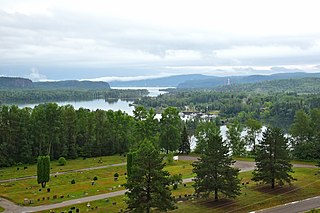
The Nipigon River is located in Thunder Bay District in Northwestern Ontario, Canada. The river is about 48 km (30 mi) long and 50 to 200 m wide, and flows from Lake Nipigon to Nipigon Bay on Lake Superior at the community of Red Rock, dropping from an elevation of 260 to 183 m. It is the largest tributary of Lake Superior.

Des Plaines Fish and Wildlife Area is an Illinois state park on 5,000 acres (2,023 ha) in Will County, Illinois, United States. It is located on floodplain adjacent to the confluence of the Des Plaines River and the Kankakee River to form the Illinois River.

Gull Lake is a large lake in central Alberta, Canada. It is a popular recreational lake with its southern shores boasting large sandy beaches. Gull Lake is centrally located between Edmonton and Calgary and lies in two counties, Ponoka County and Lacombe County. The lake is accessed west of Ponoka on Highway 53 to get to the north side, or west of Lacombe on Highway 12 to reach the southern shores.
McGregor Lake is an elongated reservoir in Southern Alberta. McGregor Lake was created in 1920 by the completion of two dams bracketing water flowing through in Snake Valley. It is situated 100 km (62 mi) southeast of Calgary in the Vulcan County.

Burches Run Wildlife Management Area, formerly Burches Run Lake WMA, is located on 55 acres (22 ha) near Wheeling in Marshall County, West Virginia. Until 2005 the wildlife management area contained a lake impounded by a dam at risk of failure. The name change occurred after the dam was removed. The terrain climbs gently above Burches Run and is covered by a mature oak-hickory second-growth forest.

The Grand Portage State Forest is a state forest located near the community of Hovland in Cook County, in extreme northeastern Minnesota. The forest encloses Judge C. R. Magney State Park, Swamp River Wildlife Management Area, Hovland Woods Scientific and Natural Area, and Spring Beauty Hardwoods Scientific and Natural Area. It borders the Grand Portage Indian Reservation to the east, the Superior National Forest to the west, and Ontario to the north. The forest is named after the Grand Portage, a historic trade route between the Great Lakes and the Northwest.
Quinebaug Lake State Park is a public recreation area covering 181 acres (73 ha) in the town of Killingly, Connecticut. The state park offers opportunities for fishing and non-motorized boating on Wauregan Reservoir. The park is managed by the Connecticut Department of Energy and Environmental Protection.
The Battlefords Provincial Park is a recreational provincial park in the Canadian Province of Saskatchewan. It is located 39 km (24 mi) north of the city of North Battleford in the RM of Meota No. 468 on Jackfish Lake. Highway 4 runs north from North Battleford to the park and Highway 204 runs through the park providing access to the park's amenities.