The Wisconsin Glacial Episode, also called the Wisconsin glaciation, was the most recent glacial period of the North American ice sheet complex, peaking more than 20,000 years ago. This advance included the Cordilleran Ice Sheet, which nucleated in the northern North American Cordillera; the Innuitian ice sheet, which extended across the Canadian Arctic Archipelago; the Greenland ice sheet; and the massive Laurentide Ice Sheet, which covered the high latitudes of central and eastern North America. This advance was synchronous with global glaciation during the last glacial period, including the North American alpine glacier advance, known as the Pinedale glaciation. The Wisconsin glaciation extended from approximately 75,000 to 11,000 years ago, between the Sangamonian Stage and the current interglacial, the Holocene. The maximum ice extent occurred approximately 25,000–21,000 years ago during the last glacial maximum, also known as the Late Wisconsin in North America.

The Last Glacial Period (LGP), also known colloquially as the Last Ice Age or simply Ice Age, occurred from the end of the Last Interglacial to the end of the Younger Dryas, encompassing the period c. 115,000 – c. 11,700 years ago.

The Winston Churchill Range is a mountain range in the central section of the Park Ranges of the Canadian Rockies located in Jasper National Park. The range was named after Sir Winston Churchill, former British prime minister.

The Fairholme Range is a mountain range east of the Bow River valley in the Canadian Rockies. The range is bounded on the west side by the Trans-Canada Highway as it passes through the towns of Exshaw and Canmore, while the northern section of the range extends into Banff National Park to the southern shores of Lake Minnewanka. John Palliser named the range in 1859 after his sister Grace Fairholme, who had married William Fairholme.

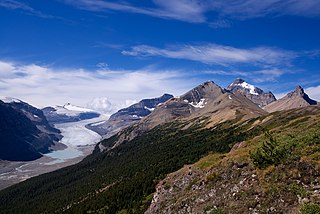
The Columbia Icefield is the largest ice field in North America's Rocky Mountains. Located within the Canadian Rocky Mountains astride the Continental Divide along the border of British Columbia and Alberta, Canada, the ice field lies partly in the northwestern tip of Banff National Park and partly in the southern end of Jasper National Park. It is about 325 square kilometres (125 sq mi) in area, 100 to 365 metres in depth and receives up to 7 metres (280 in) of snowfall per year.

Okotoks Erratic is a 16,500-tonne (18,200-ton) boulder that lies on the otherwise flat, relatively featureless, surface of the Canadian Prairies in Alberta. It is part of the 930-kilometre-long (580 mi) Foothills Erratics Train of typically angular boulders of distinctive quartzite and pebbly quartzite.

Mount Hector is a 3,394-metre (11,135-foot) mountain summit located in the Bow River valley of Banff National Park, in the Canadian Rockies of Alberta, Canada. The mountain was named in 1884 by George M. Dawson after James Hector, a geologist on the Palliser expedition. The mountain is located beside the Icefields Parkway, 17 km (11 mi) north of Lake Louise.

The retreat of glaciers since 1850 is well documented and is one of the effects of climate change. The retreat of mountain glaciers, notably in western North America, Asia, the Alps and tropical and subtropical regions of South America, Africa and Indonesia, provide evidence for the rise in global temperatures since the late 19th century. The acceleration of the rate of retreat since 1995 of key outlet glaciers of the Greenland and West Antarctic ice sheets may foreshadow a rise in sea level, which would affect coastal regions. Excluding peripheral glaciers of ice sheets, the total cumulated global glacial losses over the 26-year period from 1993 to 2018 were likely 5500 gigatons, or 210 gigatons per yr.

The Peyto Glacier is situated in the Canadian Rockies in Banff National Park, Alberta, Canada, approximately 90 km (56 mi) northwest of the town of Banff, and can be accessed from the Icefields Parkway.
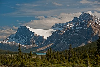
Bow Glacier is located in Banff National Park, Alberta, Canada, approximately 37 km (23 mi) northwest of Lake Louise. It can be viewed from the Icefields Parkway. Bow Glacier is an outflow glacier from the Wapta Icefield, which rests along the Continental Divide. Runoff from the glacier supplies water to Bow Lake and the Bow River. The glacier is credited for creating the Bow Valley before retreating at the end of the last glacial maximum.
Vulture Glacier is located in Banff National Park, Alberta, Canada, northwest of Lake Louise, and can be viewed from the Icefields Parkway. Vulture Glacier is an outflow glacier from the Wapta Icefield, which rests along the Continental Divide. The glacier had an area of 4.9 square kilometres (1.9 sq mi) in the 1980s, however, all of the glaciers in the Canadian Rockies have been retreating steadily since the middle of the 19th century.
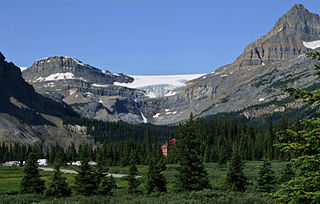
Crowfoot Glacier is located in Banff National Park, Alberta, Canada, 32 km (20 mi) northwest of Lake Louise, and can be viewed from the Icefields Parkway. The glacier is situated on the northeastern flank of Crowfoot Mountain.
The Saskatchewan Glacier is located in Banff National Park, Alberta, Canada, approximately 120 km (75 mi) northwest of the town of Banff, and can be accessed from the Icefields Parkway. Saskatchewan Glacier is the largest outflow glacier from the Columbia Icefield, which rests along the Continental Divide. The glacier is a primary water source for the North Saskatchewan River. The glacier is approximately 13 kilometres (8.1 mi) long and covers an area of 30 km2 (11.5 mi2) and was measured in 1960 to be over 400 metres (1,310 ft) thick at a distance of 8 kilometres (5.0 mi) from the terminal snout. Between the years 1893 and 1953, Saskatchewan Glacier had receded a distance of 1,364 metres (4,475 ft), with the rate of retreat between the years 1948 and 1953 averaging 55 metres (180 ft) per year. The glacier, which flows northeast, exhibits a prominent medial morraine.

The Hart Ranges are a major subrange of the Canadian Rockies located in northeastern British Columbia and western Alberta. The mountains constitute the southernmost portion of the Northern Rocky Mountains.

The David Glacier is a glacier over 60 nautical miles long, flowing east from the polar plateau through the Prince Albert Mountains to the coast of Victoria Land, Antarctica. It enters Ross Sea between Cape Philippi and Cape Reynolds to form the floating Drygalski Ice Tongue. It is the most imposing outlet glacier in Victoria Land. It is fed by two main flows which drain an area larger than 200,000 square kilometres, with an estimated ice discharge rate of 7.8 +/- 0.7 km³/year. The David Glacier was discovered by Ernest Shackleton's "Northern Party," in November 1908, under the leadership of Prof. T.W. Edgeworth David, of Sydney University, for whom the feature was named.
The Foothills Erratics Train is a 580 miles (930 km) long, narrow, linear scatter of thousands of typically angular boulders of distinctive quartzite and pebbly quartzite that lie on the surface of a generally north-south strip of the Canadian Prairies. These boulders, which are between 1 foot (0.30 m) and 135 feet (41 m) in length, are glacial erratics that lie upon a surficial blanket of Late Wisconsin glacial till. The largest glacial erratic within the Foothills Erratics Train is Big Rock.
The Mulock Glacier is a large, heavily crevassed glacier which flows into the Ross Ice Shelf 40 kilometers south of the Skelton Glacier in the Ross Dependency, Antarctica.

The Illecillewaet Glacier is a glacier in British Columbia, Canada. It is located inside Glacier National Park in the Selkirk Mountains, a sub-range of the Columbia Mountains. After the construction of the Canadian Pacific Railway (CPR) near the glacier's terminus, and the building of a hotel nearby, the glacier became a prominent tourist destination in the Canadian west. Easily accessible by road and railway, it is one of the most-studied glaciers in North America. Its retreat over the last one hundred years has been extensively documented.

Mount Murchison is a 3,353-metre (11,001 ft) mountain summit located at the convergence of the North Saskatchewan River valley and Mistaya River valley of Banff National Park, in the Canadian Rockies of Alberta, Canada. The main summit has two high points: the Southeast Peak is 3,353 m, whereas the Northwest Peak is 3,333 m and separated by 700 m distance. Its nearest higher peak is Mount Cline, 15.71 km (9.76 mi) to the north. Mount Murchison is situated immediately southeast of the confluence of the North Saskatchewan River, Mistaya River, and Howse River near Saskatchewan Crossing, where the Icefields Parkway intersects with the David Thompson Highway.