Fernie lies on the Elk River, along Canada's southernmost east-west transportation corridor through the Rockies that crosses the range via the Crowsnest Pass, 40 kilometres (25 miles) to the east. As the largest and longest-established community between Cranbrook and Lethbridge, Fernie serves as a minor regional centre, particularly for its fellow Elk Valley communities.
Geography
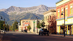
The city of Fernie, BC seen from Three Sisters mountain
Fernie is the only city-class municipality in Canada that is fully encircled by the Rocky Mountains.[3] The townsite was laid out in the crook of a doglegged glacial valley that today is drained by the Elk River. Three tributaries of the Elk—Coal, Lizard, and Fairy Creeks—rise in its side valleys and join the Elk either within or in close proximity to the townsite.
While the slopes of the mountains are the present focus of economic activity, until comparatively recently residents of the area were more interested in the mountains' innards. The vast Crowsnest Coal Field lies just to the east of the city, and Fernie owes its origins to nineteenth-century prospector William Fernie, who established the coal industry that continues to exist to this day. Acting on pioneer Michael Phillips' twin discoveries of coal and the Crowsnest Pass a few years earlier, Fernie founded the Crows Nest Pass Coal Company in 1897 and established a temporary encampment near Coal Creek. The Canadian Pacific Railway arrived in the valley the following year, and a townsite emerged parallel to the railway line slightly north of the initial encampment, or "Old Town."[4]:80
On May 23, 1902, a coal mine explosion killed 109 miners at the Crow's Nest Coal Mining Company.[5] The disaster, one of the worst mining accidents in Canadian history, is largely forgotten in Fernie and overlooked by local historians after more than a century. During World War One, an internment camp for prisoners of war was set up at rented premises in Fernie from June 1915 to October 1918.[6]
Underground coal mines were dug 10 kilometres (6.2 miles) away from the townsite in the narrow Coal Creek valley and until 1960 a small satellite community was known as Coal Creek stood adjacent to them. A variety of other mines were sunk into the coal fields in a fifty-kilometre (31mi) radius in the following two decades. No mining was ever carried out in Fernie proper; coking of Coal Creek coal was carried out at the townsite, but otherwise, the town developed into an administrative and commercial centre for the burgeoning industry. Forestry played a smaller role in the local economy and a local brewery produced Fernie Beer from Brewery Creek (mountain spring water).
Like most single-industry towns, Fernie endured several boom-and-bust cycles throughout the twentieth century, generally tied to the global price of coal. The mines at Coal Creek closed permanently by 1960 and the focus of mining activity shifted to Michel and Natal about twenty-five kilometres (16 miles) upriver, which sat on a more productive portion of the Crowsnest Coal Field. Kaiser Resources opened immense open-pit mines there in the 1970s to meet new metallurgical coal contracts for the Asian industrial market, predominantly for use in blast furnaces. Fernie would remain an important residential base for mine labour, along with the new communities of Sparwood and Elkford that sprang up much closer to these new mines. Today, Teck Resources operates four open-pit mines, shipping out in 152 car unit trains along the Canadian Pacific Railway through Fernie to the Pacific Coast, where the coal is loaded onto freighters at Roberts Bank Superport in Delta.
Flathead Valley avalanches
The Flathead Valley avalanches were two avalanches that buried 11 snowmobilers near Fernie on December 28, 2008. The avalanches ultimately claimed the lives of eight of the riders.[7]
Architectural heritage
After a disastrous fire levelled much of the downtown core in 1904, the fledgling municipal government passed an ordinance requiring all buildings in the area to be built of 'fireproof' materials like brick and stone. Consequently, a new city centre rose from the ashes sporting brick buildings along broad avenues that would have looked more at home in a sedate and refined Victorian city than a rough-and-tumble frontier coal town. They were short-lived, however, as a second, larger inferno swept through the city on August 1, 1908. Whipped up by sudden winds, a nearby forest fire burnt its way into a lumber yard on the edge of the community and sparked a Dresden-style firestorm that melted brick and mortar and essentially erased the entire city in an afternoon. There were few casualties however and for a second time, a stately brick downtown core rose from the ashes. Today, these historic buildings, most of which still stand, are a treasured and distinctive feature of the community.
Sports
Summer in Fernie is generally far quieter than the winter months, though mountain biking, fly fishing and golf are increasingly important tourist draws.
On October 17, 2017, there was an ammonia leak at the Fernie Memorial Arena which killed three workers (two City of Fernie employees and one CIMCO refrigeration employee from Calgary) during the Ghostriders' regular season. Because of this tragedy, the City of Fernie declared a state of emergency and people had to evacuate the area for days. The 'Riders were relocated because of this to the Elk Valley Leisure Centre in Sparwood, British Columbia during the 2017–18 KIJHL season until the City of Fernie decided what to do.[8][9] The City of Fernie decided to replace ammonia for a synthetic refrigerant prior to the 2018–19 KIJHL season and moved the team back to the Fernie Memorial Arena.[10]
Notable people
The following people were born, raised in or reside in Fernie:
Rogers Communications operates a cable system serving Fernie. The cable system offers most major channels from Vancouver and Calgary, as well as local programming on Rogers TV channel 10.
In the 2021 Census of Population conducted by Statistics Canada, Fernie had a population of 6,320 living in 2,597 of its 3,256 total private dwellings, a change of 17.1% from its 2016 population of 5,396. With a land area of 15.11km2 (5.83sqmi), it had a population density of 418.3/km2 (1,083.3/sqmi) in 2021.[13]
Ethnicity
Panethnic groups in the City of Fernie (1986−2021)
Fernie has a cool and wet humid continental climate (KöppenDfb) with warm summer days, cool summer nights along with cold and snowy winters. Influenced by chinook winds and being to the west of the continent, Fernie's winters are mild for its latitude in North America, although the climate is notably more continental than coastal British Columbia.
This page is based on this Wikipedia article Text is available under the CC BY-SA 4.0 license; additional terms may apply. Images, videos and audio are available under their respective licenses.