Castleguard Mountain

Last updated
Castleguard Mountain
Mount Castleguard
Columbia icefield view.jpg
Mount Castleguard (on the left)
Highest point
Elevation 3,083 m (10,115 ft) [1]
Prominence 443 m (1,453 ft) [1]
Parent peak Mount Andromeda (3450 m) [1] [2]
Listing Mountains of Alberta
Coordinates 52°06′35″N117°15′14″W / 52.10972°N 117.25389°W / 52.10972; -117.25389 [3]
Geography
Canada Alberta relief location map - transverse mercator proj.svg
Red triangle with thick white border.svg
Castleguard Mountain
Canada relief map 2.svg
Red triangle with thick white border.svg
Castleguard Mountain
Castleguard Mountain (Canada)
Parent range Canadian Rockies
Topo map NTS 83C3 Columbia Icefield [3]
Climbing
First ascent 1919 by the Interprovincial Boundary Commission [4]
Castleguard and Saskatchewan Glacier seen from Parker Ridge Castleguard Mountain with Saskatchewan Glacier.jpg
Castleguard and Saskatchewan Glacier seen from Parker Ridge

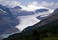
Castleguard Mountain, also known as Mount Castleguard, [4] is an isolated mountain located near the southern edge of the Columbia Icefield at the northern edge of Banff National Park in Alberta, Canada. [5] In 1918, Irish land surveyor Arthur Oliver Wheeler named the mountain because of its castle-like appearance, which seemed to stand guard over the southern portion of the Columbia Icefield. [5] [6] Castleguard was first ascended in 1919 by the Interprovincial Boundary Commission, which determined the exact location of the boundary between British Columbia and Alberta along the continental divide. [5] [4]

Contents

Author Lewis Freeman, in his 1925 book Roof of the Rockies, described the view from the summit:

Possibly lacking the sheer breath-taking wonder of the first sight of Kinchinjunga's snows from Darjeeling, the view from the summit of Castleguard is still one of the great mountain panoramas of the world. Set on the southern rim of the Columbia Icefields, with no other peak encroaching on its domain for many miles, there are no masking barriers close at hand to cut off the view in any direction. Not only are almost all the great peaks of the Canadian Rockies system notched into the splendid panorama, but also many of those of the Selkirk and Gold Ranges, far beyond the purple-shadowed depths that mark the great gorge of the Columbia River. [5]

Geology

Castleguard is composed of sedimentary rock laid down during the Precambrian to Jurassic periods. [7] Formed in shallow seas, this sedimentary rock was pushed east and over the top of younger rock during the Laramide orogeny. [8]

Climate

Based on the Köppen climate classification, Castleguard is located in a subarctic climate with cold, snowy winters, and mild summers. [9] Temperatures can drop below −20 °C (−4 °F) with wind chill factors below −30 °C (−22 °F).

See also

Related Research Articles

<span class="mw-page-title-main">Mount Louis</span> Mountain in Banff NP, Canada

Mount Louis is a 2,682-metre (8,799-foot) mountain summit located in southeast Banff National Park in Alberta, Canada. It is part of the Sawback Range which is a subset of the Canadian Rockies.

<span class="mw-page-title-main">Mount Saskatchewan (Alberta)</span> Mountain in Banff National Park, Alberta, Canada

Mount Saskatchewan is a mountain located in the North Saskatchewan River valley of Banff National Park, in the Canadian Rockies of Alberta, Canada.

<span class="mw-page-title-main">Mount Hector (Alberta)</span> Mountain in Banff National Park, Alberta, Canada

Mount Hector is a 3,394-metre (11,135-foot) mountain summit located in the Bow River valley of Banff National Park, in the Canadian Rockies of Alberta, Canada. The mountain was named in 1884 by George M. Dawson after James Hector, a geologist on the Palliser expedition. The mountain is located beside the Icefields Parkway, 17 km (11 mi) north of Lake Louise.

<span class="mw-page-title-main">Saint Nicholas Peak (Canada)</span> Mountain in Canada

Saint Nicholas Peak is a 2,938-metre (9,639-foot) mountain summit in the Rocky Mountains of Canada. It is located on the Continental Divide, on the Alberta-British Columbia border, in both Banff National Park and Yoho National Park. It lies at the eastern edge of the Wapta Icefield, and is part of the Waputik Mountains which are a sub-range of the Canadian Rockies.

<span class="mw-page-title-main">Mount Allen (Canada)</span> Mountain in Canada

Mount Allen is a mountain in the Canadian Rockies, on the Continental Divide, which forms the provincial boundary between British Columbia and Alberta in this region. J. Monroe Thorington named this mountain for Samuel Evans Stokes Allen in 1924. Allen was an American cartographer who mapped this area of the Rockies in 1894-95. Allen had named this mountain "Shappee", the Stoney language word for "six", as part of his naming of the ten mountains in the Valley of the Ten Peaks. The peak forms part of the backdrop to Moraine Lake in Banff National Park.

<span class="mw-page-title-main">Mount Balfour</span> Mountain in Canadian Rockies

Mount Balfour is a mountain located on the Continental Divide, part of the border between British Columbia and Alberta, in the Waputik Range in the Park Ranges of the Canadian Rockies. It is the 71st highest peak in Alberta and the 113th highest in British Columbia; it is also the 52nd most prominent in Alberta.

<span class="mw-page-title-main">Division Mountain</span> Mountain in the country of Canada

Division Mountain is located on the Continental Divide along the Alberta - British Columbia border of Canada. It also straddles the shared boundary of Banff National Park with Kootenay National Park in the Canadian Rockies. It was named in 1919 by Charles D. Walcott since the mountain divides the Lyell Icefield from the Mons Icefield.

<span class="mw-page-title-main">Mount Olive (Canadian Rockies)</span> Mountain in Canada

Mount Olive is located N of the head of the Yoho River on the Continental Divide, on the Alberta-British Columbia border, in both Banff National Park and Yoho National Park. It lies on the eastern edge of the Wapta Icefield, and is part of the Waputik Mountains. It was named in 1898 by H.B. Dixon after his wife Dixon, Olive.

<span class="mw-page-title-main">Observation Peak (Alberta)</span> Mountain summit in Canada

Observation Peak is a 3,174-metre (10,413-foot) mountain summit located in Banff National Park, Alberta, Canada. The mountain can be seen from the Icefields Parkway near the Bow Summit.

<span class="mw-page-title-main">Mount Aberdeen (Alberta)</span> Mountain in Alberta, Canada

Mount Aberdeen is a 3,152-metre (10,341-foot) mountain summit located in the Lake Louise area of Banff National Park, in the Canadian Rockies of Alberta, Canada. Its nearest higher peak is Mount Lefroy, 2.9 km (1.8 mi) to the southwest. Haddo Peak is on the same massif with Mount Aberdeen, and the Aberdeen Glacier is between the two peaks.

<span class="mw-page-title-main">The Castelets</span> Mountain in Banff NP, Albera, Canada

The Castelets is a 2,884-metre (9,462-foot) mountain summit located in the Alexandra River valley of Banff National Park, in the Canadian Rockies of Alberta, Canada. Its nearest higher peak is Terrace Mountain, 4.6 km (2.9 mi) to the northwest. The Castelets can be seen from the Icefields Parkway with optimum photography conditions in morning light.

<span class="mw-page-title-main">Nigel Peak</span> Mountain in the country of Canada

Nigel Peak is a 3,211-metre (10,535-foot) mountain summit located on the shared border of Banff National Park and Jasper National Park, in the Canadian Rockies of Alberta, Canada. Nigel has two peaks, the north summit is the highest point. The nearest higher peak is Mount Athabasca, 6.4 km (4.0 mi) to the south-southwest. Nigel Peak is situated immediately north of Sunwapta Pass and can be seen from the Icefields Parkway and from Athabasca Glacier. Topographic relief is significant as the summit rises 1,100 meters (3,610 feet) above the parkway in two kilometers (1.2 mile).

<span class="mw-page-title-main">Mount Jimmy Simpson</span> Mountain in Canada

Mount Jimmy Simpson is a 2,966-metre (9,731-foot) summit located 3 kilometres northwest of Bow Lake in Banff National Park, in the Canadian Rockies of Alberta, Canada. Its nearest higher peak is Mount Thompson, 3.0 km (1.9 mi) to the southwest. Mount Jimmy Simpson is a member of the Waputik Mountains, and is situated east of the Wapta Icefield and west of the Bow River valley. Mount Jimmy Simpson can be seen from the Icefields Parkway at Bow Lake. Jimmy Simpson Junior is a 2,721 meter sub-summit east of the mountain.

<span class="mw-page-title-main">Dolomite Peak</span> Mountain in Banff NP, Alberta, Canada

Dolomite Peak is a 2,998-metre (9,836-foot) mountain summit located in the Bow River valley of Banff National Park, in the Canadian Rockies of Alberta, Canada. Its nearest higher peak is Cirque Peak, 3.98 km (2.47 mi) to the northwest. Dolomite Peak can be seen from the Icefields Parkway with its distinctive crags and colorful towers that are a mixture of dolomite and limestone. Dolomite is rare in the Rockies and is stronger than limestone.

<span class="mw-page-title-main">Bow Peak</span> Mountain peak in Banff National Park, Alberta, Canada

Bow Peak is a 2,840-metre (9,320-foot) mountain summit located in the Bow River valley of Banff National Park, in the Canadian Rockies of Alberta, Canada. Its nearest higher peak is Crowfoot Mountain, 2.11 km (1.31 mi) to the east. Bow Peak is situated north of Hector Lake, southeast of Bow Lake, and can be seen from the Icefields Parkway. Although not of remarkable elevation, the mountain is a conspicuous landmark and visible from as far away as the Lake Louise area. Its position in the Waputik Mountains provides magnificent views from the summit.

<span class="mw-page-title-main">Hilda Peak</span> Mountain peak in Banff NP, Alberta, Canada

Hilda Peak is a 3,058-metre (10,033-foot) mountain summit located at the northern extreme of Banff National Park in the Canadian Rockies of Alberta, Canada. The nearest higher peak is Mount Athabasca, 2.0 km (1.2 mi) to the southwest. Hilda Peak is situated south of Sunwapta Pass and can be prominently seen from the Icefields Parkway. The Hilda Glacier lies to the south side of the peak, and the Boundary Glacier lies to the west.

<span class="mw-page-title-main">Portal Peak</span> Mountain in Banff NP, Alberta, Canada

Portal Peak is a 2,926-metre (9,600-foot) mountain summit located four kilometers west of Bow Lake in Banff National Park, in the Canadian Rockies of Alberta, Canada. Its nearest higher peak is Mount Thompson, 1.0 km (0.62 mi) to the northwest. Portal Peak is situated east of the Wapta Icefield, and is a member of the Waputik Mountains. Portal Peak can be seen from the Icefields Parkway at Bow Lake.

<span class="mw-page-title-main">Pulpit Peak</span> Mountain peak in Banff NP, Alberta, Canada

Pulpit Peak is a 2,720-metre (8,920-foot) mountain summit located one km south of Hector Lake in Banff National Park, in the Canadian Rockies of Alberta, Canada. Its nearest higher peak is Lilliput Mountain, 3.6 km (2.2 mi) to the southwest. Pulpit Peak is situated east of the Waputik Icefield, and is a member of the Waputik Mountains. Pulpit Peak can be seen from the Icefields Parkway towering 900 metres (2,950 ft) above Hector Lake.

<span class="mw-page-title-main">Big Bend Peak</span> Mountain peak in Banff NP, Alberta, Canada

Big Bend Peak is a 2,804-metre (9,199-foot) mountain summit located in the upper North Saskatchewan River valley in Banff National Park, in the Canadian Rockies of Alberta, Canada. Its nearest higher peak is Mount Saskatchewan, 5.5 km (3.4 mi) to the south. Big Bend Peak is situated on the west side of the Icefields Parkway four kilometres southwest of the "big bend" in the road, hence the peak's name origin.

<span class="mw-page-title-main">Barbette Mountain</span> Mountain in the country of Canada

Barbette Mountain is 3,072-metre (10,079-foot) summit located on the shared border of Alberta and British Columbia, Canada.

References

  1. 1 2 3 "Castleguard Mountain". Bivouac.com. Retrieved 2019-09-06.
  2. "Castleguard Mountain". Peakbagger.com. Retrieved 2019-09-06.
  3. 1 2 "Castleguard Mountain". Geographical Names Data Base . Natural Resources Canada . Retrieved 2019-04-06.
  4. 1 2 3 Thorington, J. Monroe (1966) [1921]. "Thompson Pass to Head of Athabaska River [sic]". A Climber's Guide to the Rocky Mountains of Canada. With the collaboration of Putnam, William Lowell (6th ed.). American Alpine Club. pp. 225–226. ISBN   978-1376169003.
  5. 1 2 3 4 "Mount Castleguard". SummitPost.org. Retrieved 2016-01-25.
  6. "Castleguard Mountain". cdnrockiesdatabases.ca. Retrieved 2019-09-06.
  7. Belyea, Helen R. (1960). The Story of the Mountains in Banff National Park (PDF). parkscanadahistory.com (Report). Ottawa: Geological Survey of Canada. Archived (PDF) from the original on 2015-10-02. Retrieved 2019-09-13.
  8. Gadd, Ben (2008). Geology of the Rocky Mountains and Columbias.
  9. Peel, M. C.; Finlayson, B. L.; McMahon, T. A. (2007). "Updated world map of the Köppen−Geiger climate classification". Hydrol. Earth Syst. Sci. 11: 1633–1644. ISSN   1027-5606.

Further reading