
The Rocky Mountains, also known as the Rockies, are a major mountain range and the largest mountain system in North America. The Rocky Mountains stretch 3,000 miles in straight-line distance from the northernmost part of western Canada, to New Mexico in the southwestern United States. Depending on differing definitions between Canada and the U.S., its northern terminus is located either in northern British Columbia's Terminal Range south of the Liard River and east of the Trench, or in the northeastern foothills of the Brooks Range/British Mountains that face the Beaufort Sea coasts between the Canning River and the Firth River across the Alaska-Yukon border. Its southernmost point is near the Albuquerque area adjacent to the Rio Grande rift and north of the Sandia–Manzano Mountain Range. Being the easternmost portion of the North American Cordillera, the Rockies are distinct from the tectonically younger Cascade Range and Sierra Nevada, which both lie farther to its west.
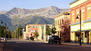
Fernie is a city in the Elk Valley area of the East Kootenay region of southeastern British Columbia, Canada, located on BC Highway 3 on the western approaches to the Crowsnest Pass through the Rocky Mountains. Founded in 1898 and incorporated as the City of Fernie in July 1904, the municipality has a population of over 5,000 with an additional 2,000 outside city limits in communities under the jurisdiction of the Regional District of East Kootenay. A substantial seasonal population swells the city during the winter months.

Fernie Alpine Resort is a ski resort, located on Lizard Range, near the town of Fernie, British Columbia in Canada. The resort also operates a mountain bike park, hiking, guided hikes, and sightseeing in the summer months.

Crowsnest Pass is a low mountain pass across the Continental Divide of the Canadian Rockies on the Alberta–British Columbia border.

The Kootenays or Kootenay is a region of southeastern British Columbia. It takes its name from the Kootenay River, which in turn was named for the Kutenai First Nations people.

The Regional District of East Kootenay (RDEK) is a regional district in the Canadian province of British Columbia, Canada. In the 2016 census, the population was 60,439. Its area is 27,542.69 km2 (10,634.29 sq mi). The regional district offices are in Cranbrook, the largest community in the region. Other important population centres include the cities of Kimberley and Fernie, and the district municipality of Invermere and Sparwood. Despite its name, the regional district does not include all of the region known as the East Kootenay, which includes the Creston Valley and the east shore of Kootenay Lake.
Mount Fernie Provincial Park is a provincial park located just west of the town of Fernie in British Columbia, Canada. It was established on May 4, 1959 to protect the ecology of the lower Lizard River while providing recreational opportunities for local residents and visitors alike. The park is named after Mount Fernie, a prominent peak located north of the park.

The Three Sisters is a mountain immediately north of Fernie, British Columbia, northwest of the confluence of Fairy Creek with the Elk River. It should not be confused with the Alberta Rockies' peaks of the same name, located further north outside Canmore.

The Muskwa Ranges are a group of mountain ranges in northern British Columbia, Canada. They are part of the Northern Rockies section of the Rocky Mountains and are bounded on their west by the Rocky Mountain Trench and on their east by the Rocky Mountain Foothills. They are delimited on the north by the Liard River and on the south by the Peace Reach of the Lake Williston reservoir, south of which the next major grouping of the Rockies is the Hart Ranges.
The Elk Valley is a valley in the southeastern Kootenay region of British Columbia, Canada. Located in the heart of the Canadian Rockies, the Elk Valley is approximately 60 kilometres from the Alberta and Montana borders.

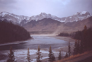
The Canadian Rockies are a segment of the North American Rocky Mountains found in the Canadian provinces of Alberta and British Columbia.

Crowsnest Range is a mountain range of the Rocky Mountains in southwestern Alberta and southeastern British Columbia, Canada.
Resorts of the Canadian Rockies Inc. (RCR) is the largest private ski resort owner/operator in Canada, owning six ski resorts across Canada.
The Nikanassin Formation is a stratigraphic unit of Late Jurassic (Portlandian) to Early Cretaceous (Barremian) age. It is present along the western edge of the Western Canada Sedimentary Basin in western Alberta and northeastern British Columbia. Its name was first proposed by D.B. Dowling in 1909 (Coal Fields South of Grand Trunk Pacific Railway, in the foothills of the Rocky Mountain, Alberta Page 140 paragraph 4 " to this it is proposed to give the name Nikanassin, from the Cree word meaning outer range" Also it is noted on the map by D.B. Dowling.(Geological Survey of Canada. Incorrect info follows: It was named by B.R. MacKay in 1929 for the Nikanassin Range of the front-central ranges of the Canadian Rockies. Mackay did not designate a type locality for the formation, although he described outcrops near the hamlet of Brûlé, north of the Yellowhead Highway outside of Jasper National Park.

The Cadomin Formation is a stratigraphic unit of Early Cretaceous age in the western part of the Western Canada Sedimentary Basin. It is extends from southeastern British Columbia through western Alberta to northeastern British Columbia, and it contains significant reservoirs of natural gas in some areas. It was named after the mining town of Cadomin, which is an acronym of "Canadian Dominion Mining".

The Fernie Formation is a stratigraphic unit of Jurassic age. It is present in the western part of the Western Canada Sedimentary Basin in western Alberta and northeastern British Columbia. It takes its name from the town of Fernie, British Columbia, and was first defined by W.W. Leach in 1914.

Morrissey Ridge is a mountain range of the Border Ranges located south-east of Fernie.

The Flathead Range is a mountain range of the Canadian Rockies in Alberta and British Columbia, Canada. It is located on the Continental Divide, east of Fernie, in the Kootenay Land District. It stretches 27 km (17 mi) lengthwise north–south from Crowsnest Pass to North Kootenay Pass. The range's toponym was officially adopted on 30 June 1912 by the Geographic Board of Canada, and was named in association with the Flathead River.

Packhorse Peak is a summit in British Columbia, Canada.
