
The Stone Mountain Provincial Park is an area of 256.91 square kilometres (99.19 sq mi) of mountain wilderness in the Canadian province of British Columbia. The park is part of the larger Muskwa-Kechika Management Area which includes the Northern Rocky Mountains Provincial Park, immediately south, and Kwadacha Wilderness Provincial Park. It and nearby Muncho Lake Provincial Park are accessed from the Alaska Highway, where it penetrates the Northern Rocky Mountains.
Artlish Caves Provincial Park is a provincial park on Vancouver Island in British Columbia, Canada.
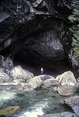
Cody Caves Provincial Park is a provincial park in British Columbia, Canada. It was formed in July 1966 to protect the Cody Caves and was the first subterranean park in British Columbia. The park is 13 km (8.1 mi) by road, northwest from the hot springs community of Ainsworth Hot Springs on Kootenay Lake.
Choquette Hot Springs Provincial Park is a provincial park located in the Stikine Country region of British Columbia, Canada. It was established on January 25, 2001, to protect Stikine River Hot Springs, the largest hot springs on the Canadian side of the lower Stikine River.

Englishman River Falls Provincial Park is a provincial park in British Columbia, Canada. It is located west of Parksville and borders the small community of Errington on Vancouver Island.
Gordon Bay Provincial Park is a provincial park in British Columbia, Canada.
Great Glacier Provincial Park is a provincial park in the Stikine Country region of British Columbia, Canada. It was established on January 25, 2001 to protect Great Glacier and the surrounding mountainous terrain. The park lies in the traditional territory of the Tahltan First Nation about 120 kilometres (75 mi) south of the Tahltan community of Telegraph Creek.
Lava Forks Provincial Park is a provincial park in northern British Columbia, Canada. It is the site of Canada's most recent volcanic eruption, which occurred around 1904 at Lava Fork.

Maquinna Marine Provincial Park and Protected Area is a provincial park in British Columbia, Canada, located northwest of Tofino in the Clayoquot Sound region of the West Coast of Vancouver Island, protecting Ramsay Hot Springs, which is the name-source of the cove, settlement and former post office of Hot Springs Cove.
Memory Island Provincial Park is a provincial park located on Vancouver Island in British Columbia, Canada. It was established by BC Parks on 23 August 1945 to protect a small island located at the southern end of Shawnigan Lake.
Mount Fernie Provincial Park is a provincial park located just west of the town of Fernie in British Columbia, Canada. It was established on May 4, 1959 to protect the ecology of the lower Lizard River while providing recreational opportunities for local residents and visitors alike. The park is named after Mount Fernie, a prominent peak located north of the park.

Myra-Bellevue Provincial Park is a provincial park in British Columbia, Canada, located in the Okanagan Highland east of Kelowna. It was established to protect the full elevational range of the North Okanagan Basin and North Okanagan Highlands ecosections.
Nitinat River Provincial Park is a provincial park in the Canadian province of British Columbia on Vancouver Island.

Shannon Falls Provincial Park is a provincial park in British Columbia, Canada. It is located 58 kilometers (36 mi) from Vancouver and 2 kilometers (1.2 mi) south of Squamish along the Sea to Sky Highway.
Sydney Inlet Provincial Park is a provincial park in the Clayoquot Sound region of the west coast of Vancouver Island, British Columbia, Canada, located north of the settlement of Hot Springs Cove and northwest of the resort town of Tofino. Sydney Inlet was the name of the post office in the area from its creation in 1947 to 1948, when it was renamed Hot Springs Cove, though that post office was subsequently closed in 1974.

Skookumchuck Narrows Provincial Park is a provincial park in the Sunshine Coast of British Columbia, Canada. It was established on August 25, 1957, to protect the Sechelt Rapids located in the Skookumchuck Narrows between Sechelt Inlet and Jervis Inlet.
Sukunka Falls Provincial Park is a provincial park in British Columbia, Canada.

Tribune Bay Provincial Park is a provincial park located on Hornby Island in British Columbia, Canada. It features a broad, crescent-shaped beach of white sand, Tribune Bay, and spring wildflowers. There are opportunities for canoeing, fishing, hiking, tennis, picnicking and open water swimming. Six pit toilets are provided.

BC Parks is an agency of the British Columbia Ministry of Environment and Climate Change Strategy that manages all of the, as of 2020, 1,035 provincial parks and other conservation and historical properties of various title designations within the province's Parks oversaw of the British Columbia Parks and Protected Areas System. The Lieutenant Governor-in-Council created the agency on March 1, 1911, through the Strathcona Park Act. The agency is charged with a dual role of preserving the ecological and historical integrity of the places entrusted to its management, while also making them available and accessible for public use and enjoyment.
Craig Headwaters Protected Area is a protected area located in the Stikine Region of British Columbia, Canada. It was established on January 25, 2001 to protect the Craig River Valley from the Alaskan border to its confluence with the Iskut River.

