The Cayoosh Range is the northernmost section of the Lillooet Ranges, which are a subrange of the Pacific Ranges of the Coast Mountains in British Columbia, Canada. The range covers an area of c. 1,000 km2 (390 sq mi) and is approximately 65 km (40 mi) SW to NE and about 20 km (12 mi) SE to NW.

Browne Lake Provincial Park is a provincial park in British Columbia, Canada, located 22 km east-southeast of Kelowna in the Okanagan Highland, near Big White Ski Resort and between the heads of Hydraulic and Grouse Creeks.

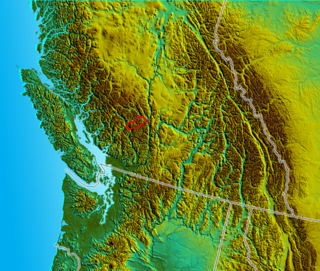
Big Bar Lake Provincial Park is a provincial park in British Columbia, Canada. It includes vehicle accessible camping, a boat launch, swimming, angling, and hiking opportunities. There are 46 campsites within the park in two very close campgrounds.
Cody Caves Provincial Park is a provincial park in British Columbia, Canada. It was formed in July 1966 to protect the Cody Caves and was the first subterranean park in British Columbia. The park is 13 km (8.1 mi) by road, northwest from the hot springs community of Ainsworth Hot Springs on Kootenay Lake.

Davis Lake Provincial Park is a 185 acres (0.75 km2) park in British Columbia, Canada, established as a protected provincial park in October 1963. It is located east of the southern end of Stave Lake, northeast of Mission, British Columbia, approximately 18 km north on Sylvester Rd from BC Highway 7. There are campgrounds and beaches at the south end of the lake, access is walk-in only via a 1 km unmaintained gravel road.

Kakwa Provincial Park and Protected Area is a 170,890 ha provincial park in northeastern British Columbia, Canada. The park preserves the southernmost portion of the Hart Ranges and the northernmost portion of the Continental Ranges. The park also preserves significant marine fossil deposits located in the region.

Kennedy Lake Provincial Park is a provincial park in British Columbia, Canada located on the SW side of Kennedy Lake, SE of Tofino, British Columbia adjacent to the Pacific Rim National Park Reserve. The park has day use facilities only.
Memory Island Provincial Park is a provincial park located on Vancouver Island in British Columbia, Canada. It was established by BC Parks on 23 August 1945 to protect a small island located at the southern end of Shawnigan Lake.

Muncho Lake Provincial Park is a provincial park in British Columbia, Canada, located on the Alaska Highway as it transits the northernmost Canadian Rockies west of Fort Nelson. The park is part of the larger Muskwa-Kechika Management Area. It is named after Muncho Lake, which is in the park and is both the name of the lake and of the community located there.
Nitinat River Provincial Park is a provincial park in the Canadian province of British Columbia on Vancouver Island.
Purden Lake Provincial Park is a provincial park in British Columbia, Canada. It is located east of Prince George. It encompasses the north and east sides of Purden Lake. It was established in August 1971 and covers 2,521 hectares. In 2018, Purden became the first accessible park in British Columbia, adding wheelchair ramps and specialist playground equipment.

Silver Lake Provincial Park is a provincial park in British Columbia, Canada, located in the Skagit River Valley just south of Hope and comprising 77 hectares.
Spectacle Lake Provincial Park is a provincial park in British Columbia, Canada, comprising 67 ha and located southeast of Shawnigan Lake on southern Vancouver Island.

Spider Lake Provincial Park is a provincial park located on Vancouver Island in British Columbia, Canada. It was established on June 18, 1981, to protect the ecological integrity of the lake and to provide day use visitors with recreational facilities.

Summit Lake Provincial Park is a Class C provincial park located southeast of the community of Summit Lake in the Central Kootenay region of British Columbia, Canada.
Cayoosh Pass is a mountain pass in the Lillooet Ranges of the Pacific Ranges of the southern Coast Mountains in British Columbia, Canada. It lies just west of Duffey Lake on BC Highway 99 between the towns of Lillooet and Pemberton, formed by the headwaters of Cayoosh Creek to the east, flowing to the Fraser River at Lillooet, and Joffre Creek to the west, flowing steeply downhill to Lillooet Lake just southeast of the Mount Currie Indian Reserve.
Haylmore Creek is the largest tributary of the Gates River, flowing northwest from its origin in the central Cayoosh Range to join that river at the community of Devine, British Columbia, Canada, in the Lillooet Country of the Southern Interior of British Columbia.

Cayoosh Creek is a northeast-flowing tributary of the Seton River in the Canadian province of British Columbia. The name Cayoosh Creek remains on the bridge-sign crossing the stream on BC Highway 99 and continues in use locally to refer to the final reaches of the Seton River, formerly Seton Creek, which prior to the renaming ending at the confluence with Cayoosh Creek. The creek is the namesake of Cayoosh Creek Indian Reserve No. 1, one of the main Indian reserves of the Cayoose Creek Indian Band, which lies adjacent to what was renamed the Seton River without local consultation.

Mount Rohr is a 2,423-metre (7,949-foot) mountain summit located in the Cayoosh Range of the Lillooet Ranges, in southwestern British Columbia, Canada. It is situated 29 km (18 mi) east of Pemberton, 8.2 km (5 mi) east of Cayoosh Mountain, and 6.8 km (4 mi) northeast of Joffre Peak, its nearest higher peak. Highway 99 traverses the southern base of the mountain between Cayoosh Pass and the west end of Duffy Lake, while Mount Chief Pascall rises on the opposite (south) side of this highway. Mount Rohr forms the westernmost boundary of Duffey Lake Provincial Park as it also represents the park's highest point. The mountain's name was submitted by Rev. Damasus Payne, a mountaineer, to honor Rev. Victor Sebastian Rohr (1873-1965), who spent 40 years in British Columbia and was a missionary to the First Nations in the region between Skookumchuck and Williams Lake. The name was officially adopted on April 21, 1966, by the Geographical Names Board of Canada. Two established climbing routes are the West Ridge and via Rohr Lake, both of which can be skied in winter. Precipitation runoff from the peak drains north into headwaters of Haylmore Creek, or south into Cayoosh Creek.

The Nlháxten/Cerise Creek Conservancy is a 2,272-hectare conservancy north of Pemberton, British Columbia, established in 2008. Located within the mountainous Joffre Group between the Pacific Cayoosh ranges, it encompasses diverse tarrain, including mountain tarns in the Anniversary Glacier area, subalpine meadows, Engelmann spruce forest ecosystems, and portions of the Cerise Creek watershed. Mount Chief Pascal stands at the center of the conservancy, with other striking peaks like Joffre Peak and Mount Matier forming its boundary. It abuts the popular Joffre Lakes Provincial Park. The area is popular for backcountry skiing and other outdoor recreation, and is the site of a mountain hut that predates the conservancy's establishment.


