
The Peace River is a 1,923-kilometre-long (1,195 mi) river in Canada that originates in the Rocky Mountains of northern British Columbia and flows to the northeast through northern Alberta. The Peace River joins the Athabasca River in the Peace-Athabasca Delta to form the Slave River, a tributary of the Mackenzie River. The Finlay River, the main headwater of the Peace River, is regarded as the ultimate source of the Mackenzie River. The combined Finlay–Peace–Slave–Mackenzie river system is the 13th longest river system in the world.

Williston Lake is a reservoir created by the W. A. C. Bennett Dam which is located in the Northern Interior of British Columbia, Canada.
Samuel Black was a Scottish fur trader and explorer, a clerk in the New North Nest Company (XYC) and Wintering Partner in the North West Company (NWC), and later clerk, chief trader, and chief factor in the Hudson's Bay Company (HBC) for the Columbia District. In 1824, he explored the Finlay River and its tributaries in present-day north-central British Columbia, Canada, including the Muskwa, Omineca and Stikine for the HBC. His journals were published by the Hudson's Bay Record Society in 1955.
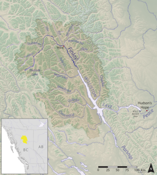
The Finlay River is a 402 km long river in north-central British Columbia flowing north and thence south from Thutade Lake in the Omineca Mountains to Williston Lake, the impounded waters of the Peace River formed by the completion of the W.A.C. Bennett Dam in 1968. Prior to this, the Finlay joined with the Parsnip River to form the Peace. The headwaters of the Finlay at Thutade Lake are considered the ultimate source of the Mackenzie River. Deserters Canyon is located just north of Williston Lake.
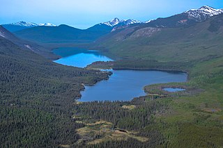
Thutade Lake is located in the Omineca Mountains of the Northern Interior of British Columbia, Canada. About 40 km (25 mi) in length, and no more than about 2 km (1.2 mi) wide, the lake is primarily significant as the ultimate source of the Mackenzie River. The lake is at the head of the Finlay River, which joins the Peace River via Williston Lake. The area is very remote, being located about 260 km (160 mi) north of Smithers, although several mining operations for ores containing copper, lead, zinc and silver have occurred around the lake. The largest of these is the Kemess Mine, an iron and copper property originally owned by Royal Oak Mines and now by Northgate Minerals, located in the valley of Kemess Creek, which is off the northeast end of Thutade Lake. The mine is accessed by the Omineca Resource Road and other resource routes, and is 400 km (250 mi) by road from Prince George. Just downstream from the outlet of Thutade Lake, the Finlay plunges over the 180-foot (55 m) Cascadero Falls, and then through a series of cataracts in a twisting course until it begins its main northeastward trend. Cascadero Falls is slated for hydroelectric development in connection with the power needs of the area's mines.
Akamina-Kishinena Provincial Park is a provincial park located in the southeastern corner of British Columbia, Canada. The park was established by order-in-council on July 13, 1995 to protect the ecological integrity of a relatively narrow stretch of the Rocky Mountains in the southeastern corner of the province.
Cummins Lakes Provincial Park and Protected Area is a provincial park and protected area located in the eastern interior of British Columbia, Canada. It was established on August 4, 2000 to protect mountainous wilderness along the Cummins River.
Dune Za Keyih Provincial Park and Protected Area, also known as the Frog-Gataga Provincial Park, is a provincial park in British Columbia, Canada. It is part of the larger Muskwa-Kechika Management Area and is located in the area of the Gataga River, between Denetiah Provincial Park, which lies west across the Kechika River, and Kwadacha Wilderness Provincial Park to its east. Established in 2001 as Frog-Gataga, the park is 346,833 hectares in area; its newer name is a Kaska Dena translation of Frog-Gataga.
Denetiah Provincial Park and Protected Area is a provincial park and protected area located in the northern interior of British Columbia, Canada. It was established on June 29, 1999 to protect a large area of pristine wilderness at the headwaters of the Denetiah and Dahl Rivers.
Finlay-Russel Provincial Park and Protected Area is a provincial park in British Columbia, Canada. It is part of the larger Muskwa-Kechika Management Area.

Kiskatinaw Provincial Park is a provincial park located in Peace River Regional District in British Columbia, Canada. It was established on May 1, 1962 to protect a prominent horseshoe-shaped incised meander in the Kiskatinaw River where a historic curved bridge crosses the river along the original alignment of the Alaska Highway.

The Purcell Wilderness Conservancy is a provincial park in British Columbia, Canada. It was established in 1974, and encompasses six large drainages in the Purcell Mountains in the southeast of the province. It contains high peaks, alpine meadows and ridges, deep creek and river valleys, and hot springs at Dewar Creek.
Spatsizi Plateau Wilderness Provincial Park is located in the northern portion of British Columbia, Canada, approximately 698, 659 hectares and encompasses the Spatsizi River and Gladys Lake Ecological Reserve. The park is a designated protected area that is intended for the conservation and research on caribou, grizzly bears, fish, and other wildlife species populations. Before the provincial park's establishment in 1975, the area was a historical hunting ground for local Indigenous communities like the Tahltan First Nations. It is the second largest provincial park in British Columbia.
The Omineca Mountains, also known as "the Ominecas", are a group of remote mountain ranges in the Boreal Cordillera of north-central British Columbia, Canada. They are bounded by the Finlay River on the north, the Rocky Mountain Trench on the east, the Nation Lakes on the south, and the upper reaches of the Omineca River on the west. They form a section of the Continental Divide, that, in this region, separates water drainage between the Arctic and Pacific Oceans. The lower course of the Omineca River flows through the heart of the range. To the south of the Ominecas is the Nechako Plateau, to the west the Skeena Mountains and Hazelton Mountains, to the north the Spatsizi Plateau and the Stikine Ranges, while east across the Rocky Mountain Trench are the Muskwa Ranges.

The Interior Mountains or Northern Interior Mountains are the semi-official names for an expansive collection of mountain ranges that comprises much of the northern half of the Canadian province of British Columbia and a large area of southern Yukon.
The Tatlatui Range is a large and very alpine mountain range on the east flank of the upper Skeena River in northern British Columbia, Canada. It has an area of 2307 km2 and is a subrange of the Omineca Mountains which in turn form part of the Interior Mountains. The range features several lakes, the largest of which, Thutade Lake, is at the head of the Finlay River, and is considered the ultimate source of the Mackenzie River. Tatlatui Lake, the next largest lake in the range, to the northwest of Thutade Lake, is at the head of the Firesteel River, a tributary of the Finlay. Various summits of the range, which as described separates the Pacific and Arctic drainages, form part of the Continental Divide. Most of the range and its lakes are in Tatlatui Provincial Park.
The Firesteel River is the uppermost left tributary of the Finlay River in the Northern Interior of British Columbia, Canada. The river originates at Tatlatui Lake, while the Finlay originates at the outlet of Thutade Lake, to the southeast, which is considered the ultimate source of the Mackenzie River.
Tatlatui Lake is a lake in the Tatlatui Range of the Omineca Mountains of the Northern Interior of British Columbia, Canada. It is the source of the Firesteel River, the uppermost left tributary of the Finlay River, which begins just southeast at Thutade Lake, which is considered the ultimate source of the Mackenzie River. The lake and adjoining summits are part of Tatlatui Provincial Park.
The Muskwa-Kechika Management Area is a provincially-run tract of land in the far north of British Columbia. It has an advisory board that counsels the government on land-use decisions. Established by provincial government legislation in 1998, the area is meant to be preserved as a wild area, but development is not outright forbidden; the land is divided into different zones, with varying levels of protection, although the whole area is to be used according to an overall plan. The original concept called for 25% of the land to be turned into provincial parks, 60% to become "special management zones", and 15% to become "special wild land zones", where logging would be prohibited. The original size of the M-KMA was 4,450,000 hectares. However, in 2000, with the approval of the Mackenzie Land and Resource Management Plan (LRMP), over 1,900,000 hectares were added to the M-KMA for a total area of 6,400,000 hectares —an area slightly smaller than the US state of Maine, or the entire island of Ireland, or seven times the size of Yellowstone National Park, in Wyoming.
Omineca Provincial Park and Protected Area is a provincial park and protected area located in the north-central interior of British Columbia, Canada. It was established on 11 April 2001 by BC Parks to protect provincially significant riparian and wetland habitats along the Omineca River.

