
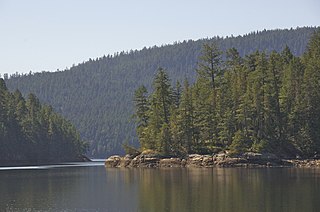
Gulf Islands National Park Reserve is a national park located on and around the Gulf Islands in British Columbia, Canada. In the National Parks System Plan, this park provides representation of the Strait of Georgia Lowlands natural region, the only place in Canada with a Mediterranean climate of dry, sunny summers and mild, wet winters, the result of a rain shadow effect from surrounding mountains between the region and the ocean. It has similar dominant vegetation as the Pacific Northwest, such as coastal Douglas-fir, western red cedar, shore pine, Pacific dogwood, bigleaf maple, and red alder, but also contains the northern extent of some of the more drought tolerant trees such as Garry oak and Arbutus. The park was created in 2003 as the fortieth national park. It covers 36 square kilometres (14 sq mi) of area on 16 islands and more than 30 islets, reefs and surrounding waters, making it the sixth smallest national park in Canada.

Porteau Cove Provincial Park is a provincial park located along the eastern shore of Howe Sound in British Columbia, Canada.

Adams Lake Provincial Park is a provincial park in British Columbia, Canada. It encompasses three distinct parks: Adams Lake Provincial Park, Adams Lake Marine Provincial Park, and Adams Lake Marine Provincial Park.
Babine Lake Marine Park is on Babine Lake, which borders the Skeena and Omineca regions of central British Columbia. This provincial park comprises six separate sites around the lake. Vehicle access to the lake, via BC Highway 16 and Nilkitkwa forestry service road, is by road about 105 kilometres (65 mi) northeast of Smithers; via BC Highway 16 and Central Babine Lake Highway, is about 132 kilometres (82 mi) east of Smithers; or via Babine Lake Road, is about 20 kilometres (12 mi) northeast of Burns Lake.
Desolation Sound Marine Provincial Park is a provincial park in British Columbia, Canada located along Desolation Sound. The park is distinguished by its many picturesque sheltered coves and anchorages, frequented by yachts and pleasure craft. The scenery consists of waterfalls, rugged glaciated peaks, and steep forested slopes that fall into the ocean.

Gibson Marine Provincial Park is a provincial park in British Columbia, Canada, located on the southeast end of Flores Island in the central Clayoquot Sound region of Vancouver Island. The park was created on 13 November 1967. It contains approximately 143 hectares and is adjacent to Flores Island Provincial Park.

Wakes Cove Provincial Park is a provincial park in the northeast corner of Valdes Island, located in the Gulf Islands in British Columbia, Canada. The park is only accessible by boat, and can be found on Marine Chart #3475 for further navigation details.

Maquinna Marine Provincial Park and Protected Area is a provincial park in British Columbia, Canada, located northwest of Tofino in the Clayoquot Sound region of the West Coast of Vancouver Island, protecting Ramsay Hot Springs, which is the name-source of the cove, settlement and former post office of Hot Springs Cove.
Mount Geoffrey Escarpment Provincial Park is a Class-A provincial park in British Columbia, Canada, located on the southwest coast of Hornby Island. It covers an area of 187 hectares, stretching from the Shingle Spit ferry landing in the west to Ford Cove in the east.
Wallace Island Marine Provincial Park is a provincial park in the Gulf Islands of British Columbia, Canada. The park includes almost all 72 hectares of Wallace Island. Land on the northern side of Princess Cove extending north towards Chivers is private. This long, thin island lies in Trincomali Channel south-west of Galiano Island, and about 2 km (1.2 mi) northeast of Saltspring Island. There are a few hiking trails, and camping is permitted in designated areas.

Penrose Island Marine Provincial Park is a provincial park in the Central Coast region of British Columbia, Canada, located on the north side of the entrance to Rivers Inlet, 86 km north of Port Hardy at the south end of Fitz Hugh Sound. Comprising 1,079 hectares of marine area and 934 hectares of land area, the park is accessible by boat only and entrance to its anchorages are on its eastern side, the western being exposed to the open ocean. Exploration by dinghy and kayak are popular with visitors, as are nature viewing, scuba diving and exploring the islands many beaches and adjoining islets. The nearest supply centre for fuel and food is at the community of Rivers Inlet.

Pirates Cove Marine Provincial Park is a provincial park on De Courcy Island in British Columbia, Canada.

Plumper Cove Marine Provincial Park is a provincial park in British Columbia, Canada. The park is located on the northwest shore of Keats Island in Howe Sound, northwest of Vancouver, British Columbia.

Raft Cove Provincial Park is a provincial park in British Columbia, Canada, located south of San Josef Bay on northwestern Vancouver Island.
Sydney Inlet Provincial Park is a provincial park in the Clayoquot Sound region of the west coast of Vancouver Island, British Columbia, Canada, located north of the settlement of Hot Springs Cove and northwest of the resort town of Tofino. Sydney Inlet was the name of the post office in the area from its creation in 1947 to 1948, when it was renamed Hot Springs Cove, though that post office was subsequently closed in 1974.

Smuggler Cove Marine Provincial Park is a provincial park in British Columbia, Canada located approximately 16 kilometres (9.9 mi) west of Sechelt, a city on the Sunshine Coast.

BC Parks is an agency of the British Columbia Ministry of Environment and Climate Change Strategy that manages all of the, as of 2020, 1,035 provincial parks and other conservation and historical properties of various title designations within the province's Parks oversaw of the British Columbia Parks and Protected Areas System. The Lieutenant Governor-in-Council created the agency on March 1, 1911, through the Strathcona Park Act. The agency is charged with a dual role of preserving the ecological and historical integrity of the places entrusted to its management, while also making them available and accessible for public use and enjoyment.

Keats Island is an inhabited island located in Howe Sound near Vancouver, British Columbia. Most people who spend time on the island are visitors to one of the camps or the Marine Park, or owners of seasonal cottages.

The Blue Mountain-Birch Cove Lakes Wilderness Area is located in Halifax, Nova Scotia, Canada. Considered to be of high ecological value, it is one of 40 designated wilderness areas in the province.

Checleset Bay is a bay on the northwest coast of Vancouver Island, British Columbia, Canada. It is located southeast of Brooks Peninsula and northwest of Kyuquot Sound. Much of the land around the bay is part of Brooks Peninsula Provincial Park. Checleset Bay has three large inlets, Nasparti Inlet, Ououkinsh Inlet, and Malksope Inlet.

