
The Blind River is a river in Algoma District in Northeastern Ontario, Canada. The river is in the Great Lakes Basin and is a tributary of Lake Huron.
The Black Sturgeon River is a river in Thunder Bay District, Northwestern Ontario, Canada, located west of the Nipigon River, that flows to Lake Superior.
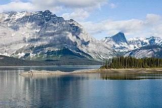
Peter Lougheed Provincial Park is in Kananaskis Country about 90 kilometres (56 mi) west of Calgary, along the Kananaskis Trail in Alberta, Canada.

The Chilcotin Ranges are a subdivision of the Pacific Ranges of the Coast Mountains. They lie on the inland lea of the Pacific Ranges, abutting the Interior Plateau of British Columbia. Their northwestern end is near the head of the Klinaklini River and their southeast end is the Fraser River just north of Lillooet; their northern flank is the edge of the Plateau while their southern is the north bank of the Bridge River. In some reckonings they do not go all the way to the Fraser but end at the Yalakom River, which is the North Fork of the Bridge.

The North Shore Mountains are a mountain range overlooking Vancouver in British Columbia, Canada. Their southernmost peaks are visible from most areas in Vancouver and form a distinctive backdrop for the city.
Cummins Lakes Provincial Park and Protected Area is a provincial park and protected area located in the eastern interior of British Columbia, Canada. It was established on August 4, 2000 to protect mountainous wilderness along the Cummins River.
Jewel Lake Provincial Park is a provincial park bordering the northwestern end of Jewel Lake in the Boundary region of south central British Columbia. The park, via BC Highway 3 and Jewel Lake Rd, is about 14 kilometres (8.7 mi) northeast of Greenwood and 48 kilometres (30 mi) northwest of Grand Forks
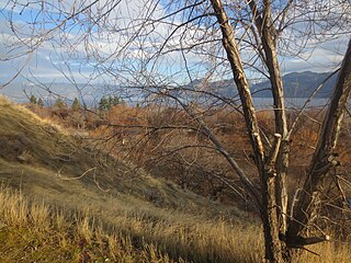
Okanagan Lake Provincial Park is a provincial park in British Columbia, Canada. Established in 1955, the park covers a total area of 98 hectares.
Woss Lake Provincial Park is a provincial park in British Columbia, Canada, located 75 kilometres southeast of Port McNeill, near the community of Woss, which is also known as Woss Lake.

Tantalus Provincial Park is a provincial park located in the Tantalus Range overlooking Squamish Valley in British Columbia, Canada. It was established on December 19, 1998 to protect a large area of pristine alpine wilderness.

The Interior Mountains or Northern Interior Mountains are the semi-official names for an expansive collection of mountain ranges that comprises much of the northern half of the Canadian province of British Columbia and a large area of southern Yukon.
Eagle Mountain, also known as Eagle Ridge, is the mountainous ridge with many indistinct summits between Buntzen Lake and Coquitlam Lake near Coquitlam, British Columbia. Its proximity to Coquitlam, and the houses being built on its southern slopes, make it a very popular weekend destination for hiking, mountain biking, horseback riding, and ATV riding. There is a network of logging roads leading up the south side of the summit to a plateau area with lakes, hiking trails and mountain biking trails.
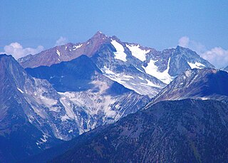
Skihist Mountain, also sometimes referred to as Skihist Peak, is the highest mountain in the Cantilever Range and in southwestern British Columbia, Canada. It is located on the southern boundary of Stein Valley Nlaka'pamux Heritage Park, about 20 km (12 mi) west of Lytton. It is the highest summit in the Lillooet Ranges, which lie between the Lillooet and Fraser Rivers, south of the Gates Valley and Seton and Anderson Lakes.

Sugarloaf Provincial Park is an 11.5-square-kilometre (4.4 sq mi) all-season provincial park located in the Campbellton community of Atholville. It opened in 1972.

The Iskut River, located in the northwest part of the province of British Columbia is the largest tributary of the Stikine River, entering it about 11 km (6.8 mi) above its entry into Alaska.
The Klappan Range is a small subrange of the Skeena Mountains of the Interior Mountains, located between Klappan River and Iskut River in northern British Columbia, Canada.
South Chilcotin Mountains Provincial Park is a provincial park in British Columbia, Canada, located on Highway 40 northwest of Lillooet, British Columbia. The park, which is 56,796 ha. in size, was established on April 18, 2001, and It was created out of a portion of the Spruce Lake Protected Area. The park is located on three Indigenous Nations: The Tsilhqot’in, St’at’imc, and Secwepemc.
Todagin Wildlife Management Area is a wildlife management area located southeast of Iskut in northwestern British Columbia. It was established by the British Columbia Ministry of Forests, Lands, Natural Resource Operations and Rural Development (FLNRORD) on 19 March 2001 to conserve and manage critical habitat for stone sheep. It is the largest wildlife management area in British Columbia at 122,787 ha.
Gladys Lake Ecological Reserve is an ecological reserve located in the Eaglenest Range of the Spatsizi Plateau in north-central British Columbia, Canada. It was established in 1975 under the Ecological Reserves Act to facilitate scientific research of the region's alpine-subalpine ecosystems while discouraging outdoor recreation use. The reserve protects 44,098 hectares of pristine wilderness and is the largest ecological reserve in British Columbia.

