
The Bridge River is an approximately 120 kilometres (75 mi) long river in southern British Columbia. It flows south-east from the Coast Mountains. Until 1961, it was a major tributary of the Fraser River, entering that stream about six miles upstream from the town of Lillooet; its flow, however, was near-completely diverted into Seton Lake with the completion of the Bridge River Power Project, with the water now entering the Fraser just south of Lillooet as a result.

The Shulaps Range is a subrange of the Chilcotin Ranges subset of the Pacific Ranges of the Coast Mountains in southwest-central British Columbia. The range is 55 km NW–SE and 15 km SW–NE and 2,970 km2 (1,150 sq mi) in area.

The Camelsfoot Range is a sub-range of the Chilcotin Ranges subdivision of the Pacific Ranges of the Coast Mountains in British Columbia. The Fraser River forms its eastern boundary. The range is approximately 90 km at its maximum length and less than 30 km wide at its widest.
The Yalakom River is a tributary of the Bridge River, which is one of the principal tributaries of the Fraser River, entering it near the town of Lillooet, British Columbia. In frontier times it was also known as the North Fork of the Bridge River, and joins the Bridge River proper at Moha, a rural community with a history in ranching, farming and mining. The river is approximately 50km in length. The valley's climate is semi-arid in character and lodgepole pine predominates below treeline.
Edge Hills Provincial Park is a provincial park in British Columbia, Canada, located west of the town of Clinton. The Edge Hills flank the wall of the Fraser Canyon north of Moran Canyon and form a small fore-range between the river and the higher Marble Range just east. Access to the Edge Hills is via the Jesmond Road, which cuts north off the Pavilion Mountain Road at Kelly Lake. A spur road from the Jesmond Road west goes to an overlook atop the Edge Hills, known as Cougar Point.

Flores Island Marine Provincial Park, also known as Flores Island Provincial Park, is a provincial park in British Columbia, Canada, located on the island of the same name in the central Clayoquot Sound region of the West Coast of Vancouver Island, British Columbia, Canada. The park contains 7113 ha. and was created on July 13, 1995, as part of the Clayoqout Land-Use Decision. Gibson Marine Provincial Park, which was created in 1967, adjoins it to the southeast. Sulphur Passage Provincial Park is off the northeast coast of Flores Island, surrounding Obstruction Island.

Gibson Marine Provincial Park is a provincial park in British Columbia, Canada, located on the southeast end of Flores Island in the central Clayoquot Sound region of Vancouver Island. The park was created on 13 November 1967. It contains approximately 143 hectares and is adjacent to Flores Island Provincial Park.

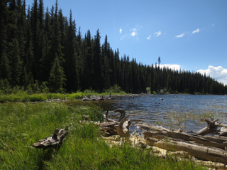
Hamber Provincial Park is a provincial park in British Columbia, Canada, located 130 kilometres (80.7 mi) north of Golden. Straddling the Great Divide on the provincial boundary with Alberta, the park is surrounded on three sides by Jasper National Park and protects the headwaters of the Wood River at Fortress Lake.
Height of the Rockies Provincial Park is a provincial park in the Canadian Rockies of south eastern British Columbia, Canada. It is located west of the Continental Divide, adjacent to Elk Lakes Provincial Park.

Herald Provincial Park is a provincial park in British Columbia, Canada. It is on the north shore of the Salmon Arm of Shuswap Lake, in the Southern Interior of British Columbia, Canada. The park is some 30 minutes northeast of the city of Salmon Arm. Herald Park contains a popular camping area, as well as a day use/picnic area. Large pebble beaches stretch along the southern boundary of the park. Walking and hiking trails exist throughout the park, including an easy 10-minute hike to the spectacular Margaret Falls.

Mara Provincial Park is a day-use provincial park in British Columbia, Canada, located on Mara Lake south of Sicamous. The park is open with services from May 1 to September 27. The gate is locked open during the off season.
Nickel Plate Provincial Park is a provincial park in British Columbia, Canada. Formerly known as Clearwater Park, it is located in the Similkameen District at the northeast corner of Nickel Plate Lake. The park is also 29km northeast of Hedley near the Apex Ski Resort.
Wapiti Lake Provincial Park is a 16,837-hectare (41,610-acre) provincial park in British Columbia, Canada. It is 60 kilometres (37 mi) south of Tumbler Ridge, at the headwaters of Wapiti River, including its watershed from the Wapiti Pass to Wapiti Lake in the Canadian Rockies. The area contains significant amounts of fossils (ichthyosaurs) and fossil beds. There is habitat for grizzly bears, mountain goats, and bull trout. It was established as a Provincial Park on June 26, 2000. It is recognized by the provincial government as being an area traditionally used by First Nations people. Hunting and fishing are permitted in the park.
Prophet River Hot Springs Provincial Park is a provincial park in British Columbia, Canada. Established high in the Muskwa Ranges, on the course of the Prophet River, it is part of the larger Muskwa-Kechika Management Area.
Tyaughton Creek, formerly gazetted as the Tyaughton River, also historically known as Tyoax Creek, is a 50 kilometre tributary of British Columbia's Bridge River, flowing generally southeast to enter the main flow of that river about mid-way along the length of Carpenter Lake, a reservoir formed by Terzaghi Dam of the Bridge River Power Project.

Churn Creek is a tributary of the Fraser River in the Canadian province of British Columbia.
Moha is a rural locality located at the confluence of the Bridge and Yalakom Rivers, 30 km northwest of Lillooet, British Columbia, Canada. The name derives from that of a rock formation on the north (right) bank of the Yalakom River overlooking the confluence, meaning "land of plenty" and which was adopted as the name of the Moha Ranch, one of several small ranches and farms in the area, which is located on the benchland above the rock formation.

