
Mount Robson Provincial Park is a provincial park in the Canadian Rockies with an area of 2,249 km2. The park is located entirely within British Columbia, bordering Jasper National Park in Alberta. The B.C. legislature created the park in 1913, the same year as the first ascent of Mount Robson by a party led by Conrad Kain. It is the second oldest park in the provincial system. The park is named for Mount Robson, which has the highest point in the Canadian Rockies and is located entirely within the park.

Duke Point is a geographical location in the extreme southeastern part of the city of Nanaimo in British Columbia. It is located on a thin peninsula to the east of the Nanaimo River estuary, just across the Northumberland Channel from Gabriola Island.
Babine Lake Marine Park is on Babine Lake, which borders the Skeena and Omineca regions of central British Columbia. This provincial park comprises six separate sites around the lake. Vehicle access to the lake, via BC Highway 16 and Nilkitkwa forestry service road, is by road about 105 kilometres (65 mi) northeast of Smithers; via BC Highway 16 and Central Babine Lake Highway, is about 132 kilometres (82 mi) east of Smithers; or via Babine Lake Road, is about 20 kilometres (12 mi) northeast of Burns Lake.
Beatton Provincial Park is a provincial park in the Peace River Country of northeastern British Columbia, Canada. It is located on the Eastern shores of Charlie Lake approximately sixteen kilometers from Fort St John, BC. The 320 hectare provincial park offers facilities that include vehicle accessible camping, boat launch, drinking water, picnic area, pit toilets, playground and a large trail system. The provincial campground only operates between May and September, but the park trail system is open year-round. The park's large trail network is maintained by the Whiskey Jack Nordic Ski Club and is used for cross-country skiing and snowshoeing in the winter and hiking in the summer. There are over 20 km of groomed cross-country ski trails designed for beginner, intermediate and advancing skiers and a toboggan hill located near the parking at the main gate.

Brandywine Falls Provincial Park is a provincial park in British Columbia, Canada, located adjacent to BC Highway 99 between Garibaldi and Whistler, British Columbia. It is managed by Sea to Sky Parks for BC Parks.
Blue Earth Lake Provincial Park is a provincial park in the Upper Hat Creek area at the south end of the Cornwall Hills, just northwest of Ashcroft, British Columbia, Canada.
Cornwall Hills Provincial Park is a provincial park in British Columbia, Canada, immediately west of Cache Creek, protecting part of the Cornwall Hills including their highest summit which features an old fire lookout.
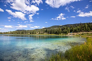
Epsom Provincial Park is a provincial park in British Columbia, Canada, located west of Ashcroft around Oregon Jack Hill.

Englishman River Falls Provincial Park is a provincial park in British Columbia, Canada. It is located west of Parksville and borders the small community of Errington on Vancouver Island.

sw̓iw̓s Provincial Park is a provincial park in British Columbia, Canada, located on the west side of Osoyoos Lake in the town of Osoyoos, which is on the Canada-United States border at the southern end of the Okanagan region of British Columbia. Approximately 38 hectares in size, the park was originally created in 1939. The name was changed from Haynes Point to sw̓iw̓s, the original Okanagan (Syilx'tsn) name for the region, meaning "narrowing of the waters".

Say Nuth Khaw Yum Provincial Park, also known as Indian Arm Provincial Park, is a provincial park located in the Lower Mainland of British Columbia, Canada. The park was established on July 13, 1995 by BC Parks to protect the forested mountain terrain of Indian Arm.
Kentucky Alleyne Provincial Park is a provincial park in British Columbia. The park is located 38 kilometres south of the city of Merritt, and east of the community of Aspen Grove. The park is named for two of its largest lakes, Kentucky Lake and Alleyne Lake. All lakes in the park have a distinctive turquoise colouration.

Lakelse Lake Provincial Park is a provincial park in British Columbia, Canada, located just west of Highway 37 between Terrace and Kitimat. The name is derived from the Coast Tsimshian language word "LaxGyels" - "fresh water mussel", for the mollusk that is found on the bottom of both Lakelse Lake and Lakelse River. Before Lakelse Lake became a provincial park, Hatchery Creek, which runs throughout the park, was the site of a sockeye salmon hatchery operated by the Canadian Government between 1919 and 1936. Lakelse Lake Provincial Park was established on March 16, 1956.

Marble Canyon Provincial Park is a provincial park in British Columbia, Canada, established in 1956 to protect Marble Canyon, a limestone formation at the south end of the Marble Range. In 2001 the park was expanded to 355 hectares to include all of Pavilion Lake due to the presence of microbialites, a type of stromatolite important to research into astrobiology and other fields, and in 2010, it was further expanded to 2,544 hectares.

Miracle Beach Provincial Park is a provincial park on the eastern shore of Vancouver Island in British Columbia, Canada. Located between Comox and Campbell River, the park includes a foreshore area in the Strait of Georgia, much of the Black Creek estuary, and a forested area. According to its Master Plan, it fulfills primarily a recreational role with a focus on beach play, picnicking, nature appreciation, and camping, and a secondary conservation role with a focus on the natural shoreline and estuary. In support of its recreational focus the park is developed with a day-use parking area with accessible trails leading to the shoreline and a camping area with 200 drive-in sites. The park is also hosts a nature centre building and a sheltered group picnic shelter. Vegetation in the park is typical for the region's second-growth forests with Douglas-fir most prominent. Common associates include Western hemlock, Sitka spruce, red alder and bigleaf maple. Salal and sword fern are the most abundant shrub. Black Creek, which flows through the park, is a spawning area for coho salmon.
Monte Creek Provincial Park is a provincial park in British Columbia, Canada, located in the locality of Monte Creek, British Columbia. Created in 1996, it is only 3 hectares in size, and protects a forested riparian area and also quiggly hole ("kekuli") sites of the Shuswap people, which have been formally studied as an archaeological site. The location was also part of the route of the Hudson's Bay Brigade Trail to the Cariboo via Kamloops from what is now the United States, as was Monte Lake in the upper basin of the eponymous creek.

The Spruce Lake Protected Area, formerly known variously as the Southern Chilcotin Mountains Provincial Park, Southern Chilcotins, and also as South Chilcotin Provincial Park, is a 71,347-hectare Protected Area in the British Columbia provincial parks system, approximately 200 km north of Vancouver. The area had been the subject of an ongoing preservationist controversy since the 1930s. In 2007, its status as a provincial park was downgraded to protected area.
Syringa Park is a provincial park on the east shore of Lower Arrow Lake in the West Kootenay region of southeastern British Columbia. At the foot of the Norns Range, Tulip Creek passes through the centre, and Syringa Creek is closer to the southeastern boundary. The park is about 19 kilometres (12 mi) west of Castlegar via Broadwater Rd.

Cultus Lake is a lake, associated community and provincial park in the Fraser Valley region of British Columbia, Canada. It is the source of the Sweltzer River. Cultus Lake is located 11 kilometres (6.8 mi) south of the Chilliwack River, near the city of Chilliwack and approximately 80 kilometres (50 mi) east of Vancouver. In 1950, Cultus Lake became a provincial park of British Columbia. Cultus Lake covers an area of 656 hectares, evenly on either side of the lake. At one time the lake had a sawmill and booming ground until it became a provincial park in the 1950s.

Mount Seymour Provincial Park is a park in Vancouver, British Columbia's North Shore Mountains. With an area of 35 square kilometres, it is located approximately 15 kilometres north of Downtown Vancouver. The park, named after Frederick Seymour, was established in 1936. Mount Seymour Provincial Park provides visitors with a variety of recreational activities and animals with natural habitat.

