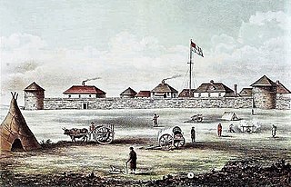
Fort Garry, also known as Upper Fort Garry, was a Hudson's Bay Company trading post located at the confluence of the Red and Assiniboine rivers in or near the area now known as The Forks in what is now central Winnipeg, Manitoba.

The Canadian Rockies or Canadian Rocky Mountains, comprising both the Alberta Rockies and the British Columbian Rockies, is the Canadian segment of the North American Rocky Mountains. It is the easternmost part of the Canadian Cordillera, which is the northern segment of the North American Cordillera, the expansive system of interconnected mountain ranges between the Interior Plains and the Pacific Coast that runs northwest–southeast from central Alaska to the Isthmus of Tehuantepec in Mexico.

Mount Robson Provincial Park is a provincial park in the Canadian Rockies with an area of 2,249 km2. The park is located entirely within British Columbia, bordering Jasper National Park in Alberta. The B.C. legislature created the park in 1913, the same year as the first ascent of Mount Robson by a party led by Conrad Kain. It is the second oldest park in the provincial system. The park is named for Mount Robson, which has the highest point in the Canadian Rockies and is located entirely within the park.

Shuswap Lake is a lake located in the southern interior of British Columbia, Canada that drains via the Little Shuswap River into Little Shuswap Lake. Little Shuswap Lake is the source of the South Thompson River, a branch of the Thompson River, a tributary of the Fraser River. It is at the heart of a region known as the Columbia Shuswap or "the Shuswap", noted for its recreational lakeshore communities including the city of Salmon Arm. The name "Shuswap" is derived from the Shuswap or Secwepemc First Nations people, the most northern of the Interior Salish peoples, whose territory includes the Shuswap. The Shuswap call themselves /ʃǝxwépmǝx/ in their own language, which is called /ʃǝxwepmǝxtʃín/.

Adams Lake Provincial Park is a provincial park in British Columbia, Canada. It encompasses three distinct parks: Adams Lake Provincial Park, Adams Lake Marine Provincial Park, and Adams Lake Marine Provincial Park.
Bishop River Provincial Park is a provincial park in the Pacific Ranges of the Coast Mountains on the Mainland of British Columbia, Canada, located southwest of and adjoining Ts'yl-os Provincial Park."Bishop River Park". BC Geographical Names. It lies along the upper course of the Bishop River, the main tributary of the Southgate River, from the Bishop's source at the western side of the Lillooet Icecap to midway along its course above its confluence with the Southgate. The park is 19,947 ha. in size. There are no roads or trails in the park although a forest service road from Waddington Harbour at the head of Bute Inlet leads up the Southgate to within a few miles of the park boundary.
Cariboo River Provincial Park is a provincial park in British Columbia, Canada, located between Barkerville and Likely in the upper Cariboo River basin.

Englishman River Falls Provincial Park is a provincial park in British Columbia, Canada. It is located west of Parksville and borders the small community of Errington on Vancouver Island.

Hamber Provincial Park is a provincial park in British Columbia, Canada, located 130 kilometres (80.7 mi) north of Golden. Straddling the Great Divide on the provincial boundary with Alberta, the park is surrounded on three sides by Jasper National Park and protects the headwaters of the Wood River at Fortress Lake.
Harbour Dudgeon Lakes Provincial Park is a provincial park in British Columbia, Canada, located west of the Adams River, northwest of Celista Mountain. It was established on April 30, 1996. The park is located approximately 175 km northeast of Kamloops.
Momich Lakes Provincial Park is a provincial park in British Columbia, Canada, located at the north end of Adams Lake 100 kilometres (62 mi) northeast of Kamloops.
Upper Lillooet Provincial Park is a provincial park in British Columbia, Canada. The 19,996-hectare park was established on July 28, 1997, under the National Parks Act.
Upper Seymour River Provincial Park is a provincial park in British Columbia, Canada. Located in an isolated area in the interior of the province, 40 kilometres north of the community of Seymour Arm. It protects at the headwaters of the Seymour River, which is the major drainage system into the Seymour Arm of Shuswap Lake.

Tsútswecw Provincial Park is a provincial park in British Columbia, Canada, located northeast of Kamloops and northwest of Salmon Arm. It stretches along the banks of the Adams River, between the south end of Adams Lake and the western portion of Shuswap Lake.
Schoen Lake Provincial Park is a provincial park in northeastern Vancouver Island, British Columbia, Canada, located east of the community of Woss Lake and southwest of Sayward. The park lies inside the Nimpkish Valley watershed. On October 28, 1977, the "Class A" park was officially created to protect, exhibit and interpret an example of the natural features and processes of the Insular Mountains Natural Region. The park covers a total area of 8,775 hectares. Within those hectares of park land is a number of lakes, creeks and mountain ranges.

Stamp River Provincial Park is a provincial park in British Columbia, Canada. The 327-hectare park is located 14 km north of Port Alberni on Vancouver Island. There are 23 camping spaces and 2 km of trails within the park along the Stamp River, named for Edward Stamp, a sawmill pioneer in the Alberni Valley.
Stuart River Provincial Park is a provincial park in British Columbia, Canada. It is located in two sections north and northwest of Vanderhoof along the Stuart River southeast of Stuart Lake and the city of Fort St. James. The upper section is located at 54°13′20″N124°00′00″W and comprises c.7391 ha. while the lower, eastern section is centred at 54°03′00″N123°37′00″W and comprises c.3390 ha. and is within the Greater Prince George area. The upper site, which is located around the confluence of the Stuart and Nechako Rivers, includes the site of Chinlac, a Dakelh village whose inhabitants were massacred and enslaved by the Tsilhqot'in of Anahim Lake c. 1745.

Adams River is a tributary to the Thompson and Fraser Rivers in British Columbia, Canada. Beginning in the Monashee Mountains to the north, the Upper Adams River flows mainly southward and eventually reaches Adams Lake. The Lower Adams River begins at the southern end of the lake and flows into the extreme western end of Shuswap Lake. The river is one of the most important sockeye salmon breeding areas in North America. The run occurs in mid-October and can bring millions of fish to a concentrated area near the river mouth. Excavations of Secwepemc villages on the river have shown a long tradition of habitation and salmon fishing in the area. The river also served as an important transportation route for early logging operations in the watershed.
Tumtum Lake is a small lake located in the Upper Adams River valley in the Interior of British Columbia, Canada. It is a popular fishing lake, containing rainbow trout, bull trout, and whitefish. "Tumtum" is a Chinook Jargon word for "heart", or the "pulsing of the heart", and may refer to the sound of the waterfalls on the Upper Adams River downstream from the lake.
Oregana Creek Provincial Park is a provincial park in British Columbia, Canada, located 150 kilometres northwest of Salmon Arm, British Columbia, near Adams River. The park, which is 286 ha. in size, was established in 2010.

