Related Research Articles

Gulf Islands National Park Reserve is a national park located on and around the Gulf Islands in British Columbia, Canada. In the National Parks System Plan, this park provides representation of the Strait of Georgia Lowlands natural region, the only place in Canada with a Mediterranean climate of dry, sunny summers and mild, wet winters, the result of a rain shadow effect from surrounding mountains between the region and the ocean. It has similar dominant vegetation as the Pacific Northwest, such as coastal Douglas-fir, western red cedar, shore pine, Pacific dogwood, bigleaf maple, and red alder, but also contains the northern extent of some of the more drought tolerant trees such as Garry oak and Arbutus. The park was created in 2003 as the fortieth national park. It covers 36 square kilometres (14 sq mi) of area on 16 islands and more than 30 islets, reefs and surrounding waters, making it the sixth smallest national park in Canada.

Sidney is a town located at the northern end of the Saanich Peninsula, on Vancouver Island in the Canadian province of British Columbia. It's 1 of the 13 Greater Victoria municipalities. It has a population of approximately 11,583. Sidney is located just east of Victoria International Airport, and about 6 km (4 mi) south of BC Ferries' Swartz Bay Terminal. The town is also the only Canadian port-of-call in the Washington State Ferries system, with ferries running from Sidney to the San Juan Islands and Anacortes. Sidney is located along Highway 17, which bisects the town from north to south. It is generally considered part of the Victoria metropolitan area.

Mayne Island is a 21-square-kilometre (8.1 sq mi) island in the southern Gulf Islands chain of British Columbia. It is midway between the Lower Mainland of BC and Vancouver Island, and has a population of 995. Mount Parke in the south-central heart of the island is its highest peak at 255 metres.
The Farallon Islands, or Farallones, are a group of islands and sea stacks in the Gulf of the Farallones, off the coast of San Francisco, California, United States. The islands are also sometimes referred to by mariners as the Devil's Teeth Islands, in reference to the many treacherous underwater shoals in their vicinity. The islands lie 30 miles (48 km) outside the Golden Gate and 20 miles (32 km) south of Point Reyes, and are visible from the mainland on clear days. The islands are part of the City and County of San Francisco. The only inhabited portion of the islands is on Southeast Farallon Island (SEFI), where researchers from Point Blue Conservation Science and the U.S. Fish and Wildlife Service stay. The islands are closed to the public.

Cassin's auklet is a small, chunky seabird that ranges widely in the North Pacific. It is the only species placed in the genus Ptychoramphus. It nests in small burrows and because of its presence on well studied islands in British Columbia and off California it is one of the better known auks. It is named for the American ornithologist John Cassin.

Ucluelet is a district municipality on the Ucluelet Peninsula on the west coast of Vancouver Island in British Columbia, Canada. Ucluelet means "people of the safe harbour" in the indigenous Nuu-chah-nulth (Nootka) language. As of 2021, its population was 2,066, a 20.3% increase from 1,717 in 2016.

Gwaii Haanas National Park Reserve, National Marine Conservation Area, and Haida Heritage Site, usually referred to simply as Gwaii Haanas, is located in southernmost Haida Gwaii, 130 kilometres off the mainland of British Columbia, Canada. Gwaii Haanas protects an archipelago of 138 islands, the largest being Moresby Island and the southernmost being Kunghit Island. "Gwaii Haanas" means "Islands of Beauty" in X̱aayda kíl, the language of the Haida people.

Protected areas of Canada consist of approximately 12.1 percent of the nation's landmass and freshwater are considered conservation areas, including 11.4 percent designated as protected areas. Approximately 13.8 percent of Canada's territorial waters are conserved, including 8.9 percent designated as protected areas. Terrestrial areas conserved have increased by 65 percent in the 21st century, while marine areas conserved have increased by more than 3,800 percent.
Lanz and Cox Islands Provincial Park is a provincial park in British Columbia, Canada. It is located off Cape Scott on northern Vancouver Island.
BC Parks is an agency of the British Columbia Ministry of Environment and Climate Change Strategy that manages all of the, as of 2020, 1,035 provincial parks and other conservation and historical properties of various title designations within the province's Parks oversaw of the British Columbia Parks and Protected Areas System. The Lieutenant Governor-in-Council created the agency on March 1, 1911, through the Strathcona Park Act. The agency is charged with a dual role of preserving the ecological and historical integrity of the places entrusted to its management, while also making them available and accessible for public use and enjoyment.
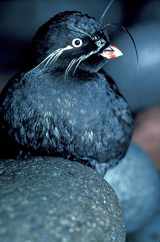
Aethia is a genus of four small (85–300g) auklets endemic to the North Pacific Ocean, Bering Sea and Sea of Okhotsk and among some of North America's most abundant seabirds. The relationships between the four true auklets remains unclear. Auklets are threatened by invasive species such as Arctic foxes and Norway rats because of their high degree of coloniality and crevice-nesting.

Anne Vallée was one of the first biologists to observe the impact of climate change on animal populations.
A National Wildlife Area is a conservation designation for a geographical region in Canada that restricts most human activities on that region. However, land use permits may be issued "for activities that are compatible with conservation". Such areas are established and managed by the Canadian Wildlife Service, a division of Environment and Climate Change Canada. They may consist of land and water features, as well as coastal areas extending up to 12 nautical miles (22 km) from shore.

Nirjutiqavvik National Wildlife Area is a National Wildlife Area on Coburg Island within the Qikiqtaaluk Region, Nunavut, Canada. It is located in Baffin Bay's Lady Ann Strait between Ellesmere Island, to the north, and Devon Island to the south. The NWA includes Coburg Island and its surrounding marine area.

Castle Rock National Wildlife Refuge is 0.5 miles (0.80 km) offshore from Crescent City in northern California. This coastal rock covers approximately 14 acres (57,000 m2), and rises steeply 335 feet (102 m) above sea level. The refuge provides an important sanctuary for the Aleutian cackling goose and nesting seabirds.

The Pacific North Coast Integrated Management Area is one of five Large Ocean Management Areas (LOMAs), areas of high ecological, social and economic importance, that have been identified by Fisheries and Oceans Canada (DFO) as priority regions for marine planning as part of Canada’s Oceans Action Plan.
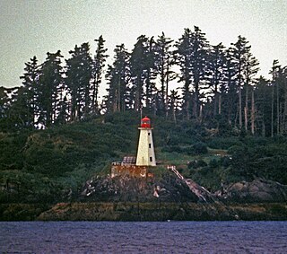
The Lucy Islands are a small archipelago off the North Coast of the province of British Columbia in Canada. The low-lying and heavily forested group, named after its largest island, Lucy Island, constitutes a provincially protected conservancy area that contains some of the North Coast’s oldest archeological sites, a nationally significant seabird population, and a prominent 20th-century lighthouse.
Widgeon Valley National Wildlife Area is a National Wildlife Area located near the south end of Pitt Lake in British Columbia, Canada. The property was purchased by the Nature Trust of British Columbia in 1973 and declared a National Wildlife Area by the Canadian Wildlife Service in October of that year. The Widgeon Valley National Wildlife Area is a biologically diverse marsh wetland. It is the traditional territory of various First Nations groups. The Widgeon Valley Wildlife Area is a protected wildlife area that is home to a number of sensitive waterfowl and fish species. The public uses the channels through the Widgeon Valley National Wildlife Area for recreational canoeing, anywhere else within the protected area is strictly off-limits to the public. There are future plans to develop interpretive trails through the park and open it to the public.
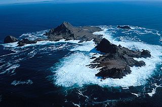
The Scott Islands are a group of islands located off the northwestern point of Vancouver Island, British Columbia.
Scott Islands Marine National Wildlife Area is a National Wildlife Area off the northwestern tip of Vancouver Island in the Canadian province of British Columbia. Covering an area of 11,570.65 km2 (4,467.45 sq mi), it is the second largest protected area in British Columbia after Offshore Pacific Seamounts and Vents Closure and is the largest national wildlife area in Canada.
References
- 1 2 3 4 Anne Vallee Triangle Island Ecological Reserve Purpose Statement Ministry of Environment
- 1 2 Triangle Island Seabird Research Station General Information
- ↑ British Columbia Geographical Names
- ↑ "Triangle Island Lighthouse".
- ↑ Triangle Island, BC, Lighthouse Friends
- ↑ Corday, Chris (2017). "Forbidden Island". CBC News. Toronto. Retrieved March 30, 2021.
- ↑ "The Scott Islands: a proposed marine national wildlife area". Environment and Climate Change Canada.