
Mount Assiniboine, also known as Assiniboine Mountain, is a pyramidal peak mountain on the Great Divide, on the British Columbia/Alberta border in Canada.
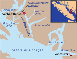
Skookumchuck Narrows is a strait forming the entrance of Sechelt Inlet on British Columbia's Sunshine Coast in Canada. Before broadening into Sechelt Inlet, all of its tidal flow together with that of Salmon Inlet and Narrows Inlet must pass through Sechelt Rapids. At peak flows, standing waves, whitecaps, and whirlpools form at the rapids even in calm weather. The narrows are also the site of Skookumchuck Narrows Provincial Park.

The Rainbow Range is a small subrange of the Park Ranges subdivisions of the Northern Continental Ranges of the Rocky Mountains on the border between Alberta and British Columbia in Mount Robson Provincial Park.
Burgoyne Bay Provincial Park is a provincial park in British Columbia, Canada located on southwestern Saltspring Island near Fulford Harbour. The parks faces northwest to Sansum Narrows, which is the channel between Saltspring Island and Vancouver Island. Mount Maxwell Provincial Park lies adjacent to the north.
Duffey Lake Provincial Park is a provincial park in British Columbia, Canada, located at the lake of the same name, which lies along BC Highway 99 just east of the summit of Cayoosh Pass. The lake's inflow and outflow are Cayoosh Creek. The park's highest point is Mount Rohr at the westernmost boundary.

Englishman River Falls Provincial Park is a provincial park in British Columbia, Canada. It is located west of Parksville and borders the small community of Errington on Vancouver Island.
Hai Lake–Mount Herman Provincial Park is a provincial park in British Columbia, Canada. Established in 2004, it is 323 ha. and protects regionally significant bog ecosystems and old-growth forests. The park caters to outdoor pursuits such as day hiking, camping, fishing, and hunting.
Kinaskan Lake Provincial Park is a provincial park in British Columbia, Canada, located at the south end of Kinaskan Lake along the Stewart-Cassiar Highway near Mowdade Lake and southeast of Mount Edziza. At the south end of the park, the Iskut River, of which the lake is an expansion, spills over 12.2-metre Cascade Falls. The park is approximately 800 ha. in size.

Little Qualicum Falls Provincial Park is a provincial park in British Columbia, Canada, on central Vancouver Island, that encompasses the entire southern shore of Cameron Lake. The Island Rail Corridor line to Port Alberni passes through the park.

Mount Elphinstone Provincial Park is a provincial park located near BC Highway 101, in British Columbia, Canada. Located near Mount Elphinstone, the park is on the west side of Howe Sound and north of the town of Gibsons and near the community of Roberts Creek. Created in 2000, the park is approximately 141 hectares in size.
Mount Fernie Provincial Park is a provincial park located just west of the town of Fernie in British Columbia, Canada. It was established on May 4, 1959 to protect the ecology of the lower Lizard River while providing recreational opportunities for local residents and visitors alike. The park is named after Mount Fernie, a prominent peak located north of the park.
Mount Geoffrey Escarpment Provincial Park is a Class-A provincial park in British Columbia, Canada, located on the southwest coast of Hornby Island. It covers an area of 187 hectares, stretching from the Shingle Spit ferry landing in the west to Ford Cove in the east.
Mount Griffin Provincial Park is a provincial park in British Columbia, Canada, located southwest of Three Valley Gap.

Mount Maxwell Provincial Park is a provincial park in the Gulf Islands of British Columbia, Canada. It is located on Burgoyne Bay and the Sansum Narrows on the western shores of Saltspring Island.
Mount Pope Provincial Park is a provincial park in British Columbia, Canada, located 7km northwest of Fort St. James in the Omineca Country region of that province's Central Interior. Mount Pope is about 1420 meters high and composed of limestone. The trail to the summit from Stones Bay Road gains about 700m and may be followed year-round. There are a few dozen developed rock climbs up to seven pitches long on the lower flanks of the mountain.
Mount Richardson Provincial Park is a provincial park in British Columbia, Canada, located on the lower Sunshine Coast to the north of Sechelt.
Mount Savona Provincial Park is a provincial park in British Columbia, Canada. The park is located west of the city of Kamloops and contains cultural sites of the Skeetchestn First Nation.
Mount Terry Fox Provincial Park is a provincial park in British Columbia, Canada. It is located in the Rocky Mountains near Mount Robson and the city of Valemount, British Columbia. The park and Mount Terry Fox, which is within the park, are named in honor of amputee long-distance runner and cancer research activist Terry Fox, a native of Winnipeg, Manitoba who grew up in British Columbia.

Paul Lake Provincial Park is a provincial park in British Columbia, Canada, located southwest of Heffley Lake and to the northeast of the city of Kamloops.
A mountain formerly known as Mount Pétain, but with no current official name, is located on the border of the Canadian provinces of Alberta and British Columbia (BC) on the Continental Divide.

