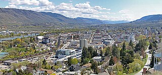
Kamloops is a city in south-central British Columbia, Canada, at the confluence of the South flowing North Thompson River and the West flowing Thompson River, east of Kamloops Lake. It is located in the Thompson-Nicola Regional District, whose district offices are based here. The surrounding region is sometimes referred to as the Thompson Country.

The Thompson River is the largest tributary of the Fraser River, flowing through the south-central portion of British Columbia, Canada. The Thompson River has two main branches, the South Thompson River and the North Thompson River. The river is home to several varieties of Pacific salmon and trout. The area's geological history was heavily influenced by glaciation, and the several large glacial lakes have filled the river valley over the last 12,000 years. Archaeological evidence shows human habitation in the watershed dating back at least 8,300 years. The Thompson was named by Fraser River explorer, Simon Fraser, in honour of his friend, Columbia Basin explorer David Thompson. Recreational use of the river includes whitewater rafting and angling.
Savona is a small community located at the west end of Kamloops Lake, where the Thompson River exits it. It is approximately halfway between Kamloops and Cache Creek along the Trans-Canada Highway. The countryside surrounding the community is semi-arid grasslands and hills, which support cattle ranching and agriculture. It has about 2000 hours of sunshine and less than 12 inches of precipitation a year. It has a population of approximately 650.

Adams Lake Provincial Park is a provincial park in British Columbia, Canada. It encompasses three distinct parks: Adams Lake Provincial Park, Adams Lake Marine Provincial Park, and Adams Lake Marine Provincial Park.
Harbour Dudgeon Lakes Provincial Park is a provincial park in British Columbia, Canada, located west of the Adams River, northwest of Celista Mountain. It was established on April 30, 1996. The park is located approximately 175 km northeast of Kamloops.

Juniper Beach Provincial Park is a provincial park in British Columbia, Canada. It is located on the north side of the Thompson River west of the town of Savona, downstream of the outflow of Kamloops Lake. The park was established in 1989, and protects dry sagebrush and desert ecology. The park is 260 hectares in size.
Momich Lakes Provincial Park is a provincial park in British Columbia, Canada, located at the north end of Adams Lake 100 km northeast of Kamloops.
Mud Lake Delta Provincial Park is a provincial park in British Columbia, Canada, located in the North Thompson Country due east of Blue River, 230 km from Kamloops on BC Highway 5.
Walloper Lake Provincial Park is a provincial park in British Columbia, Canada. Walloper Lake is a small lake located on the Trans-Canada Highway, 38 kilometres (24 mi) from the city of Kamloops.
Porcupine Meadows Provincial Park is a 2,704 hectare provincial park in British Columbia, Canada, located north of Tranquille Lake to the northwest of Kamloops. Its name is a direct translation of the Shuswap word for this area, "pisitsoolsia", named so for the numerous porcupine in the area.

Tsútswecw Provincial Park is a provincial park in British Columbia, Canada, located northeast of Kamloops and northwest of Salmon Arm. It stretches along the banks of the Adams River, between the south end of Adams Lake and the western portion of Shuswap Lake.
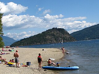
Shuswap Lake Provincial Park is a provincial park in British Columbia, Canada.
Tsintsunko Lakes Provincial Park is a 333-hectare provincial park in British Columbia, Canada, located south of the Deadman River between Kamloops (SE) and Bonaparte Lake (NW). It is located on the Bonaparte Plateau. It was established April 30, 1996.

Mount Ray, also known as Ray Mountain, is a subglacial mound in Wells Gray Provincial Park, British Columbia, Canada. Mount Ray last erupted during the Pleistocene. It is part of the Wells Gray-Clearwater volcanic field.

The Iskut River, located in the northwest part of the province of British Columbia is the largest tributary of the Stikine River, entering it about 11 km (6.8 mi) above its entry into Alaska.
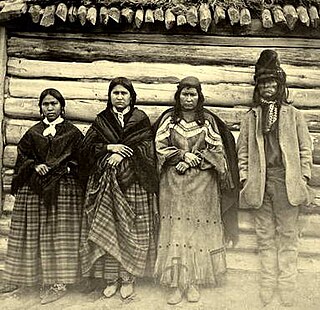
Jean Baptiste Lolo also known as St. Paul or Chief St. Paul, or Chief Lolo, was an employee and interpreter with the Hudson's Bay Company in pre-Confederation British Columbia, Canada. Son of Chief Michael Okanese 'Little Bone' Cardinal. First serving in the region at Fort Fraser in the New Caledonia fur district, he acquired the nickname there of St. Paul because of his affection for that saint. He was the right-hand man of John Tod and followed him to Fort Kamloops, where Tod was Chief Trader from 1841 to 1843, and remained in that region for the rest of his life. He acquired such great respect among the local Secwepemc (Shuswap) people as to become regarded as a chief.
"His face was a very fine one, although sickness and pain had worn it away terribly. His eyes were black, piercing and restless; his cheekbones high, and the lips, naturally thin and close, had that white, compressed look which tells so surely of constant suffering."
When Mayne remarked that Lolo, in his decayed health, must find it hard to rule over his people,
"... he heard me with a grim smile, and for answer turned back his pillow, where a loaded gun and a naked sword lay ready to his hand."
The invalid Lolo showed, in fact, unexpected reserves of strength. Rising from his bed, he mounted his horse, and accompanied Mayne on a ride to see the view from the top of a neighbouring mountain, which was forthwith named Mt. St. Paul in honour of the old chief. Moreover, Lolo insisted on accompanying Mayne on the next lap of his journey, that from Kamloops to Pavilion."
Mount Lolo, 1748m (5735'), prominence 818m, is a summit 20 km northeast of Kamloops, British Columbia, Canada, between Paul and Heffley Lakes. The summit is part of a small portion of the Interior Plateau which lies within the angle of the confluence of the South and North Thompson Rivers, to the east of which is an upland area known as the Shuswap Highland.
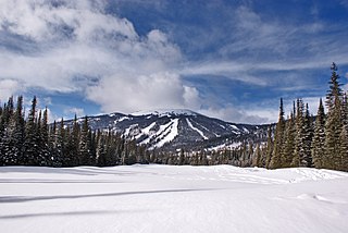
Mount Tod commonly known as Tod Mountain, is a summit 50 km northeast of Kamloops, British Columbia, Canada. Located northeast of the junction of Louis and McGillivray Creeks, it is part of the upland area between the Interior Plateau (W) and the Monashee Mountains (E) known as the Shuswap Highland, the mountain is the highest of three summits comprising the Sun Peaks alpine ski resort.

Terry Lake is a former Canadian politician, at the municipal and provincial levels, and veterinarian.
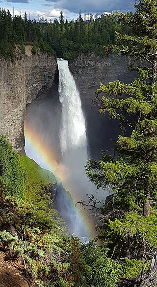
Wells Gray Provincial Park is a large wilderness park located in east-central British Columbia, Canada. The park protects most of the southern, and highest, regions of the Cariboo Mountains and covers 5,415 square kilometres. It is British Columbia's fifth largest provincial park, after Tweedsmuir, Tatshenshini, Spatsizi and Northern Rocky Mountains.


