
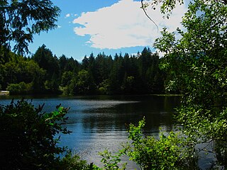
Porteau Cove Provincial Park is a provincial park located along the eastern shore of Howe Sound in British Columbia, Canada.

Northern Bay is a small community on the northern tip of Conception Bay on the Bay de Verde Peninsula, Subdivision 1G, Newfoundland and Labrador, Canada.

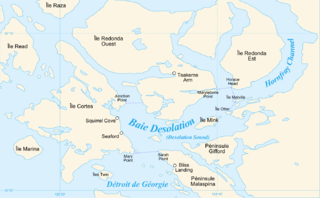
Desolation Sound is a deep water sound at the northern end of the Salish Sea and of the Sunshine Coast in British Columbia, Canada.
Dixie Cove Marine Provincial Park, originally Dixie Cove Provincial Park, is a provincial park in British Columbia, Canada, located on the east side of Hohoae Island, which is just west of Fair Harbour in Kyuquot Sound on the West Coast of Vancouver Island.
Apodaca Provincial Park is a provincial park located on the central eastern shoreline of Bowen Island, British Columbia, Canada.

Gibson Marine Provincial Park is a provincial park in British Columbia, Canada, located on the southeast end of Flores Island in the central Clayoquot Sound region of Vancouver Island. The park was created on 13 November 1967. It contains approximately 143 hectares and is adjacent to Flores Island Provincial Park.

Wakes Cove Provincial Park is a provincial park in the northeast corner of Valdes Island, located in the Gulf Islands in British Columbia, Canada. The park is only accessible by boat, and can be found on Marine Chart #3475 for further navigation details.

Maquinna Marine Provincial Park and Protected Area is a provincial park in British Columbia, Canada, located northwest of Tofino in the Clayoquot Sound region of the West Coast of Vancouver Island, protecting Ramsay Hot Springs, which is the name-source of the cove, settlement and former post office of Hot Springs Cove.
Murrin Provincial Park is a provincial park in British Columbia, Canada, located just south of Squamish beside the Sea-to-Sky Highway. The park is approximately 24 ha. in size and has a popular highway-side picnic ground and small swimming lake, but it is most notable for a collection of petroglyphs located away from the highway and accessed by trail. Several rockfaces in the area of the park are popular with the local mountain-climbing community, though the site is nowhere as busy as the nearby Stawamus Chief.
Oliver Cove Marine Provincial Park, also known as Port Blackney, is a provincial park at the southwest end of the Don Peninsula on the North Coast of British Columbia, Canada. It is accessible only by boat, but lacks docks or other facilities. The park comprises 26 hectares of marine area and 48 hectares of land area.
Wallace Island Marine Provincial Park is a provincial park in the Gulf Islands of British Columbia, Canada. The park includes almost all 72 hectares of Wallace Island. Land on the northern side of Princess Cove extending north towards Chivers is private. This long, thin island lies in Trincomali Channel south-west of Galiano Island, and about 2 km (1.2 mi) northeast of Saltspring Island. There are a few hiking trails, and camping is permitted in designated areas.

Pirates Cove Marine Provincial Park is a provincial park on De Courcy Island in British Columbia, Canada.

Plumper Cove Marine Provincial Park is a provincial park in British Columbia, Canada. The park is located on the northwest shore of Keats Island in Howe Sound, northwest of Vancouver, British Columbia.

Raft Cove Provincial Park is a provincial park in British Columbia, Canada, located south of San Josef Bay on northwestern Vancouver Island.
Santa Gertrudis-Boca del Infierno Provincial Park, legally Santa-Boca Provincial Park, is a provincial park on Nootka Island in British Columbia, Canada. It was established on 30 April 1996 to protect and Santa Gertrudis Cove and Boca del Infierno Bay, which are located on the southeastern shore of Nootka Island.

Smuggler Cove Marine Provincial Park is a provincial park in British Columbia, Canada located approximately 16 kilometres (9.9 mi) west of Sechelt, a city on the Sunshine Coast.
The Marine Drive is a designated scenic route along Nova Scotia's Eastern Shore. It closely follows the coast of the Atlantic Ocean and the Strait of Canso from the Canso Causeway to the junction of Route 322 and Highway 111 in Dartmouth.
Nova Scotia Route 253 is a collector road in the Canadian province of Nova Scotia.

Route 213 is a highway on the Burin Peninsula of the island of Newfoundland in the Canadian province of Newfoundland and Labrador. It is one of a small number of provincial routes that start and end on the same highway. It is a very short route, running for about 12 kilometres. Due to being a rough road, the maximum speed limit is 60 km/h, except through communities where the speed limit is reduced to 30 km/h. The western side of the route allows for a drive along the shore of Fortune Bay, until reaching the community of Frenchman's Cove. Midway along the route is Frenchman's Cove Provincial Park, one of only a small number of provincial parks in existence since 1997. After exiting Frenchman's Cove, motorists travel along the Frenchman's Cove Barasway and enjoy more of a view of Fortune Bay until approaching the Town of Garnish.
Waddington Channel is a strait located between East Redonda and West Redonda Island of the Discovery Islands in British Columbia, Canada.


